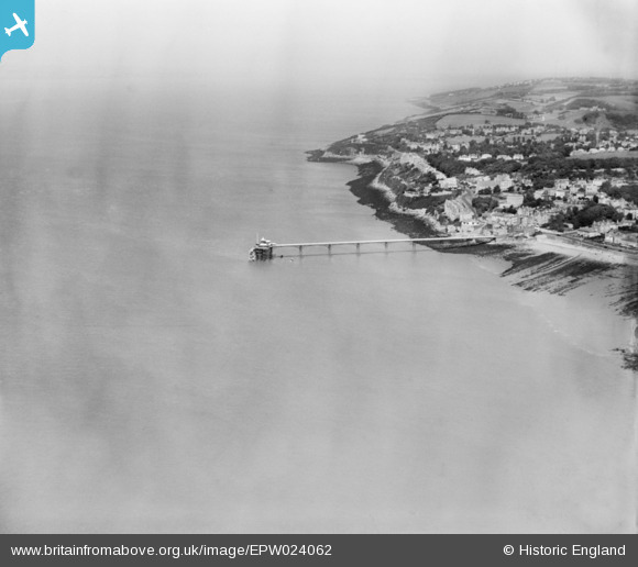
EPW024062 ENGLAND (1928). The Pier, Clevedon, from the south-west, 1928
© Copyright OpenStreetMap contributors and licensed by the OpenStreetMap Foundation. 2025. Cartography is licensed as CC BY-SA.
Nearby Images (5)
Details
| Title | [EPW024062] The Pier, Clevedon, from the south-west, 1928 |
| Reference | EPW024062 |
| Date | September-1928 |
| Link | |
| Place name | CLEVEDON |
| Parish | CLEVEDON |
| District | |
| Country | ENGLAND |
| Easting / Northing | 339911, 171875 |
| Longitude / Latitude | -2.8646736332876, 51.442186122941 |
| National Grid Reference | ST399719 |
Pins

Class31 |
Friday 1st of February 2013 09:07:30 PM | |

Class31 |
Tuesday 9th of October 2012 08:58:17 PM | |

Class31 |
Tuesday 9th of October 2012 08:56:45 PM | |

Class31 |
Tuesday 9th of October 2012 08:55:55 PM | |

Class31 |
Tuesday 9th of October 2012 08:54:37 PM | |

Class31 |
Tuesday 9th of October 2012 08:52:59 PM |
User Comment Contributions
Catholic Church of the Immaculate Conception, Clevedon, 02/01/2015 |

Class31 |
Tuesday 6th of January 2015 02:32:41 PM |
The Beach, Clevedon, 02/01/2015 |

Class31 |
Tuesday 6th of January 2015 02:32:10 PM |
The Pier and the Beach, Clevedon, 02/01/2015 |

Class31 |
Tuesday 6th of January 2015 02:30:42 PM |
Towards the pier. |

Class31 |
Monday 24th of June 2013 11:40:46 AM |
From the pier looking north. |

Class31 |
Monday 24th of June 2013 11:32:30 AM |


![[EPW024062] The Pier, Clevedon, from the south-west, 1928](http://britainfromabove.org.uk/sites/all/libraries/aerofilms-images/public/100x100/EPW/024/EPW024062.jpg)
![[EPW024068] The Pier and Dial Hill, Clevedon, from the west, 1928](http://britainfromabove.org.uk/sites/all/libraries/aerofilms-images/public/100x100/EPW/024/EPW024068.jpg)
![[EPW024065] The Pier, Clevedon, 1928](http://britainfromabove.org.uk/sites/all/libraries/aerofilms-images/public/100x100/EPW/024/EPW024065.jpg)
![[EPW033270] The Pier, Clevedon, 1930](http://britainfromabove.org.uk/sites/all/libraries/aerofilms-images/public/100x100/EPW/033/EPW033270.jpg)
![[EPW008632] The Pier, Clevedon, 1923](http://britainfromabove.org.uk/sites/all/libraries/aerofilms-images/public/100x100/EPW/008/EPW008632.jpg)