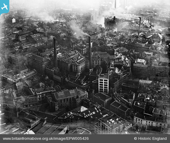
EPW005426 ENGLAND (1921). Fry's Cocoa Manufactory on Union Street and environs, Bristol, 1921
    © Copyright OpenStreetMap contributors and licensed by the OpenStreetMap Foundation. 2025. Cartography is licensed as CC BY-SA.
  
Nearby Images (19)
Details
| Title | [EPW005426] Fry's Cocoa Manufactory on Union Street and environs, Bristol, 1921 | 
| Reference | EPW005426 | 
| Date | 20-March-1921 | 
| Link | |
| Place name | BRISTOL | 
| Parish | |
| District | |
| Country | ENGLAND | 
| Easting / Northing | 358940, 173204 | 
| Longitude / Latitude | -2.5910221238419, 51.45583629378 | 
| National Grid Reference | ST589732 | 
Pins
|  Diocesan School, Nelson St. Drawn 1825. Demolished 1930s for employment exchange http://museums.bristol.gov.uk/emuweb/php5/media.php?irn=27400 |   Braikenridge | Monday 27th of April 2015 01:11:33 PM | 
|  Georgian 7 storey sugar house bulldozed post war. Seen in 1820s watercolours with loading wharf on the river frome |   Braikenridge | Sunday 12th of October 2014 12:58:53 PM | 
|  The (old) Bristol Crown Courts. |   NicTomkins | Thursday 24th of July 2014 05:53:57 PM | 
|  Bridewell Fire Station and Headquarters of Bristol Fire Brigade. (Building still there) |   NicTomkins | Thursday 24th of July 2014 05:51:23 PM | 
|  Headquarters of Bristol Constabulary.(Building still there) |   NicTomkins | Thursday 24th of July 2014 05:49:53 PM | 
|  Bridewell Street | Class31 | Monday 8th of October 2012 01:06:06 PM | 
|  Wine Street | Class31 | Monday 8th of October 2012 01:02:03 PM | 
|  Nelson Street | Class31 | Monday 8th of October 2012 01:01:22 PM | 
|  St. Peter's Church gutted by enemy action 1940. | Class31 | Monday 8th of October 2012 01:00:20 PM | 
|  J S Fry & Sons on building. | Class31 | Monday 8th of October 2012 12:58:33 PM | 
User Comment Contributions
| Natasha Scullion | Monday 24th of June 2013 03:21:56 PM | 
 
             
  ![[EPW005426] Fry's Cocoa Manufactory on Union Street and environs, Bristol, 1921](http://britainfromabove.org.uk/sites/all/libraries/aerofilms-images/public/100x100/EPW/005/EPW005426.jpg) 
  
                                          ![[EPW005423] Fry's Cocoa Manufactory on Union Street and environs, Bristol, 1921](http://britainfromabove.org.uk/sites/all/libraries/aerofilms-images/public/100x100/EPW/005/EPW005423.jpg) 
 ![[EPW005425] Fry's Cocoa Manufactory on Union Street and environs, Bristol, 1921](http://britainfromabove.org.uk/sites/all/libraries/aerofilms-images/public/100x100/EPW/005/EPW005425.jpg) 
 ![[EPW005427] Fry's Cocoa Manufactory on Union Street and environs, Bristol, 1921](http://britainfromabove.org.uk/sites/all/libraries/aerofilms-images/public/100x100/EPW/005/EPW005427.jpg) 
 ![[EPW005424] Fry's Cocoa Manufactory on Union Street and environs, Bristol, 1921](http://britainfromabove.org.uk/sites/all/libraries/aerofilms-images/public/100x100/EPW/005/EPW005424.jpg) 
 ![[EPW005421] Fry's Cocoa Manufactory on Union Street and environs, Bristol, 1921](http://britainfromabove.org.uk/sites/all/libraries/aerofilms-images/public/100x100/EPW/005/EPW005421.jpg) 
 ![[EPW005420] Fry's Cocoa Manufactory on Union Street and environs, Bristol, 1921](http://britainfromabove.org.uk/sites/all/libraries/aerofilms-images/public/100x100/EPW/005/EPW005420.jpg) 
 ![[EPW005422] Fry's Cocoa Manufactory on Union Street and environs, Bristol, 1921](http://britainfromabove.org.uk/sites/all/libraries/aerofilms-images/public/100x100/EPW/005/EPW005422.jpg) 
 ![[EPW060118] The city centre, Bristol, 1938](http://britainfromabove.org.uk/sites/all/libraries/aerofilms-images/public/100x100/EPW/060/EPW060118.jpg) 
 ![[EPW033500] St James' Park and the city, Bristol, from the south-west, 1930](http://britainfromabove.org.uk/sites/all/libraries/aerofilms-images/public/100x100/EPW/033/EPW033500.jpg) 
 ![[EPW005428] Rupert Street and environs, Bristol, 1921](http://britainfromabove.org.uk/sites/all/libraries/aerofilms-images/public/100x100/EPW/005/EPW005428.jpg) 
 ![[EPW005419] Lewins Mead and environs, Bristol, 1921](http://britainfromabove.org.uk/sites/all/libraries/aerofilms-images/public/100x100/EPW/005/EPW005419.jpg) 
 ![[EAW050553] Broadmead and environs, Bristol, 1953](http://britainfromabove.org.uk/sites/all/libraries/aerofilms-images/public/100x100/EAW/050/EAW050553.jpg) 
 ![[EPW022277] The city, Bristol, from the east, 1928](http://britainfromabove.org.uk/sites/all/libraries/aerofilms-images/public/100x100/EPW/022/EPW022277.jpg) 
 ![[EPW005431] Rupert Street and environs, Bristol, 1921](http://britainfromabove.org.uk/sites/all/libraries/aerofilms-images/public/100x100/EPW/005/EPW005431.jpg) 
 ![[EPW060117] The city centre, Bristol, 1938](http://britainfromabove.org.uk/sites/all/libraries/aerofilms-images/public/100x100/EPW/060/EPW060117.jpg) 
 ![[EPW005429] Quay Street and environs, Bristol, 1921](http://britainfromabove.org.uk/sites/all/libraries/aerofilms-images/public/100x100/EPW/005/EPW005429.jpg) 
 ![[EPW005432] Quay Street and environs, Bristol, 1921](http://britainfromabove.org.uk/sites/all/libraries/aerofilms-images/public/100x100/EPW/005/EPW005432.jpg) 
 ![[EPW047090] Colston Avenue and the city centre, Bristol, 1935](http://britainfromabove.org.uk/sites/all/libraries/aerofilms-images/public/100x100/EPW/047/EPW047090.jpg) 
 