
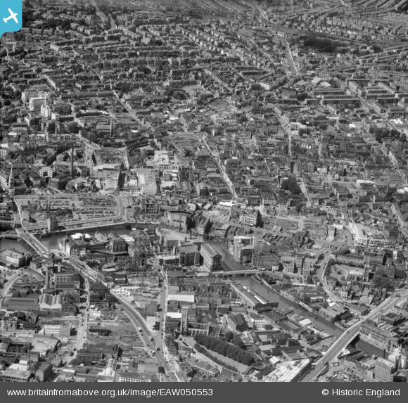
EAW050553 ENGLAND (1953). Broadmead and environs, Bristol, 1953
© Copyright OpenStreetMap contributors and licensed by the OpenStreetMap Foundation. 2026. Cartography is licensed as CC BY-SA.
Nearby Images (14)
EAW050553

EPW005420

EPW060117

EPW005421

EPW005424

EPW005422

EPW005425

EPW005426

EPW034456

EPW005423

EPW034450

EPW005427

EPW034451

EPW033500

Details
| Title | [EAW050553] Broadmead and environs, Bristol, 1953 |
| Reference | EAW050553 |
| Date | 9-July-1953 |
| Link | |
| Place name | BRISTOL |
| Parish | |
| District | |
| Country | ENGLAND |
| Easting / Northing | 359141, 173233 |
| Longitude / Latitude | -2.588132423408, 51.456111611488 |
| National Grid Reference | ST591732 |
Pins

derek2847 |
Monday 5th of February 2018 02:55:42 AM | |
|
Braikenridge |
Thursday 30th of April 2015 12:31:43 PM | |
|
Boy from Bristol |
Thursday 26th of February 2015 06:01:41 PM | |
|
Boy from Bristol |
Thursday 26th of February 2015 06:00:09 PM | |
|
MildBunch |
Wednesday 18th of February 2015 03:26:26 PM | |
this is summer 1954, building the first ground level roundabout and bond street. |
Braikenridge |
Thursday 12th of January 2017 11:21:00 AM |
|
MildBunch |
Wednesday 18th of February 2015 02:54:26 PM | |
|
MildBunch |
Wednesday 18th of February 2015 02:54:05 PM | |
|
MildBunch |
Wednesday 18th of February 2015 02:53:03 PM | |
|
MildBunch |
Wednesday 18th of February 2015 02:52:00 PM | |
|
MildBunch |
Wednesday 18th of February 2015 02:51:41 PM | |
|
MildBunch |
Wednesday 18th of February 2015 02:51:19 PM | |
|
MildBunch |
Wednesday 18th of February 2015 02:50:48 PM | |
|
MildBunch |
Wednesday 18th of February 2015 02:50:32 PM |
