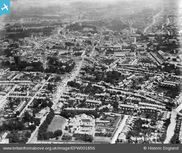
EPW001856 ENGLAND (1920). View of Colchester, the Water Tower and Crouch Street area, Colchester, 1920
© Copyright OpenStreetMap contributors and licensed by the OpenStreetMap Foundation. 2026. Cartography is licensed as CC BY-SA.
Nearby Images (16)
Details
| Title | [EPW001856] View of Colchester, the Water Tower and Crouch Street area, Colchester, 1920 |
| Reference | EPW001856 |
| Date | June-1920 |
| Link | |
| Place name | COLCHESTER |
| Parish | |
| District | |
| Country | ENGLAND |
| Easting / Northing | 599284, 224935 |
| Longitude / Latitude | 0.89615247177883, 51.886855638516 |
| National Grid Reference | TL993249 |
Pins

PrezAlan |
Monday 16th of March 2015 07:35:51 PM | |

PrezAlan |
Monday 16th of March 2015 07:29:57 PM | |

PrezAlan |
Monday 16th of March 2015 07:28:34 PM | |

PrezAlan |
Monday 16th of March 2015 07:25:59 PM | |

romons |
Saturday 4th of May 2013 09:41:52 AM | |

romons |
Saturday 4th of May 2013 09:38:29 AM | |

stimarco |
Saturday 25th of August 2012 06:31:33 PM | |

stimarco |
Saturday 25th of August 2012 06:28:44 PM |


![[EPW001856] View of Colchester, the Water Tower and Crouch Street area, Colchester, 1920](http://britainfromabove.org.uk/sites/all/libraries/aerofilms-images/public/100x100/EPW/001/EPW001856.jpg)
![[EAW014001] The town, Colchester, from the south, 1948](http://britainfromabove.org.uk/sites/all/libraries/aerofilms-images/public/100x100/EAW/014/EAW014001.jpg)
![[EAW029724] Crouch Street, St John's Street and the town, Colchester, 1950](http://britainfromabove.org.uk/sites/all/libraries/aerofilms-images/public/100x100/EAW/029/EAW029724.jpg)
![[EAW029726] Chael Street, Head Street and the town, Colchester, 1950](http://britainfromabove.org.uk/sites/all/libraries/aerofilms-images/public/100x100/EAW/029/EAW029726.jpg)
![[EAW043687] Butt Road, Headgate and the surrounding town, Colchester, 1952](http://britainfromabove.org.uk/sites/all/libraries/aerofilms-images/public/100x100/EAW/043/EAW043687.jpg)
![[EAW043686] Maldon Road and the surrounding town, Colchester, 1952](http://britainfromabove.org.uk/sites/all/libraries/aerofilms-images/public/100x100/EAW/043/EAW043686.jpg)
![[EAW029725] The town, Colchester, 1950](http://britainfromabove.org.uk/sites/all/libraries/aerofilms-images/public/100x100/EAW/029/EAW029725.jpg)
![[EAW037256] Head Street, North Hill and the town, Colchester, 1951. This image has been produced from a print.](http://britainfromabove.org.uk/sites/all/libraries/aerofilms-images/public/100x100/EAW/037/EAW037256.jpg)
![[EPW001861] The town, Colchester, from the south-west, 1920. This image has been produced from a copy-negative.](http://britainfromabove.org.uk/sites/all/libraries/aerofilms-images/public/100x100/EPW/001/EPW001861.jpg)
![[EPW001855] View of Colchester and Le Cateau Barracks, Colchester, 1920](http://britainfromabove.org.uk/sites/all/libraries/aerofilms-images/public/100x100/EPW/001/EPW001855.jpg)
![[EPW001860] Head Street and environs, Colchester, 1920. This image has been produced from a copy-negative.](http://britainfromabove.org.uk/sites/all/libraries/aerofilms-images/public/100x100/EPW/001/EPW001860.jpg)
![[EAW029733] Head Street, Shewell Road and the town, Colchester, 1950](http://britainfromabove.org.uk/sites/all/libraries/aerofilms-images/public/100x100/EAW/029/EAW029733.jpg)
![[EAW024675] The town, Colchester, 1949](http://britainfromabove.org.uk/sites/all/libraries/aerofilms-images/public/100x100/EAW/024/EAW024675.jpg)
![[EAW029732] Head Street, Culver Street and the town, Colchester, 1950](http://britainfromabove.org.uk/sites/all/libraries/aerofilms-images/public/100x100/EAW/029/EAW029732.jpg)
![[EAW043688] Le Cateau Baracks and the town, Colchester, from the south-west, 1952](http://britainfromabove.org.uk/sites/all/libraries/aerofilms-images/public/100x100/EAW/043/EAW043688.jpg)
![[EAW037494] The town centre, Colchester, 1951. This image has been produced from a print.](http://britainfromabove.org.uk/sites/all/libraries/aerofilms-images/public/100x100/EAW/037/EAW037494.jpg)