
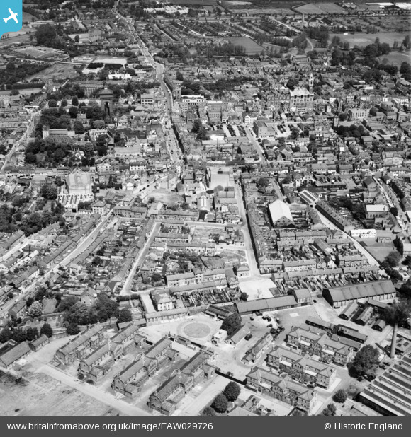
EAW029726 ENGLAND (1950). Chael Street, Head Street and the town, Colchester, 1950
© Copyright OpenStreetMap contributors and licensed by the OpenStreetMap Foundation. 2026. Cartography is licensed as CC BY-SA.
Nearby Images (17)
EAW029726

EAW043687

EPW001861

EAW014001

EAW029725

EPW001856

EAW029724

EAW043688

EAW014000

EPW001855

EPW001858

EAW029727

EAW029733

EAW029732

EAW037256

EAW037255

EAW037494

Details
| Title | [EAW029726] Chael Street, Head Street and the town, Colchester, 1950 |
| Reference | EAW029726 |
| Date | 30-May-1950 |
| Link | |
| Place name | COLCHESTER |
| Parish | |
| District | |
| Country | ENGLAND |
| Easting / Northing | 599433, 224887 |
| Longitude / Latitude | 0.89828711847094, 51.88637129791 |
| National Grid Reference | TL994249 |
Pins

Ian Partridge |
Friday 30th of August 2019 11:02:27 AM | |
|
woodsy007 |
Sunday 27th of July 2014 10:51:02 PM | |
|
woodsy007 |
Sunday 27th of July 2014 10:49:49 PM | |
|
woodsy007 |
Sunday 27th of July 2014 10:48:36 PM | |
|
woodsy007 |
Sunday 27th of July 2014 10:47:44 PM | |
|
woodsy007 |
Sunday 27th of July 2014 10:46:52 PM | |
|
woodsy007 |
Sunday 27th of July 2014 10:44:23 PM |