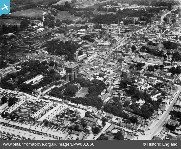
EPW001860 ENGLAND (1920). Head Street and environs, Colchester, 1920. This image has been produced from a copy-negative.
© Copyright OpenStreetMap contributors and licensed by the OpenStreetMap Foundation. 2026. Cartography is licensed as CC BY-SA.
Nearby Images (22)
Details
| Title | [EPW001860] Head Street and environs, Colchester, 1920. This image has been produced from a copy-negative. |
| Reference | EPW001860 |
| Date | June-1920 |
| Link | |
| Place name | COLCHESTER |
| Parish | |
| District | |
| Country | ENGLAND |
| Easting / Northing | 599370, 225172 |
| Longitude / Latitude | 0.89753754161327, 51.888953246467 |
| National Grid Reference | TL994252 |
Pins
Be the first to add a comment to this image!


![[EPW001860] Head Street and environs, Colchester, 1920. This image has been produced from a copy-negative.](http://britainfromabove.org.uk/sites/all/libraries/aerofilms-images/public/100x100/EPW/001/EPW001860.jpg)
![[EAW037256] Head Street, North Hill and the town, Colchester, 1951. This image has been produced from a print.](http://britainfromabove.org.uk/sites/all/libraries/aerofilms-images/public/100x100/EAW/037/EAW037256.jpg)
![[EPW018553] The Water Tower and view down the High Street, Colchester, 1927](http://britainfromabove.org.uk/sites/all/libraries/aerofilms-images/public/100x100/EPW/018/EPW018553.jpg)
![[EAW024675] The town, Colchester, 1949](http://britainfromabove.org.uk/sites/all/libraries/aerofilms-images/public/100x100/EAW/024/EAW024675.jpg)
![[EPW018555] St Peter's Church and the High Street, Colchester, 1927](http://britainfromabove.org.uk/sites/all/libraries/aerofilms-images/public/100x100/EPW/018/EPW018555.jpg)
![[EAW029724] Crouch Street, St John's Street and the town, Colchester, 1950](http://britainfromabove.org.uk/sites/all/libraries/aerofilms-images/public/100x100/EAW/029/EAW029724.jpg)
![[EAW029733] Head Street, Shewell Road and the town, Colchester, 1950](http://britainfromabove.org.uk/sites/all/libraries/aerofilms-images/public/100x100/EAW/029/EAW029733.jpg)
![[EAW029731] The Municipal Water Tower and High Street, Colchester, 1950](http://britainfromabove.org.uk/sites/all/libraries/aerofilms-images/public/100x100/EAW/029/EAW029731.jpg)
![[EAW029725] The town, Colchester, 1950](http://britainfromabove.org.uk/sites/all/libraries/aerofilms-images/public/100x100/EAW/029/EAW029725.jpg)
![[EAW029732] Head Street, Culver Street and the town, Colchester, 1950](http://britainfromabove.org.uk/sites/all/libraries/aerofilms-images/public/100x100/EAW/029/EAW029732.jpg)
![[EAW037494] The town centre, Colchester, 1951. This image has been produced from a print.](http://britainfromabove.org.uk/sites/all/libraries/aerofilms-images/public/100x100/EAW/037/EAW037494.jpg)
![[EAW037257] North Hill, the High Street and town centre, Colchester, 1951. This image has been produced from a print.](http://britainfromabove.org.uk/sites/all/libraries/aerofilms-images/public/100x100/EAW/037/EAW037257.jpg)
![[EAW037492] The town centre, Colchester, 1951. This image has been produced from a print.](http://britainfromabove.org.uk/sites/all/libraries/aerofilms-images/public/100x100/EAW/037/EAW037492.jpg)
![[EAW015359] The town, Colchester, 1948. This image has been produced from a damaged negative.](http://britainfromabove.org.uk/sites/all/libraries/aerofilms-images/public/100x100/EAW/015/EAW015359.jpg)
![[EPW018552] The town hall, Colchester, 1927](http://britainfromabove.org.uk/sites/all/libraries/aerofilms-images/public/100x100/EPW/018/EPW018552.jpg)
![[EPW058741] The Town Hall, Colchester, 1938](http://britainfromabove.org.uk/sites/all/libraries/aerofilms-images/public/100x100/EPW/058/EPW058741.jpg)
![[EAW037493] The High Street, Colchester, 1951. This image has been produced from a print.](http://britainfromabove.org.uk/sites/all/libraries/aerofilms-images/public/100x100/EAW/037/EAW037493.jpg)
![[EAW037258] Culver Street, the High Street and town centre, Colchester, 1951. This image has been produced from a print.](http://britainfromabove.org.uk/sites/all/libraries/aerofilms-images/public/100x100/EAW/037/EAW037258.jpg)
![[EPW018559] The High Street, Colchester, 1927](http://britainfromabove.org.uk/sites/all/libraries/aerofilms-images/public/100x100/EPW/018/EPW018559.jpg)
![[EAW043687] Butt Road, Headgate and the surrounding town, Colchester, 1952](http://britainfromabove.org.uk/sites/all/libraries/aerofilms-images/public/100x100/EAW/043/EAW043687.jpg)
![[EPW001856] View of Colchester, the Water Tower and Crouch Street area, Colchester, 1920](http://britainfromabove.org.uk/sites/all/libraries/aerofilms-images/public/100x100/EPW/001/EPW001856.jpg)
![[EAW037255] St John's Street and the town, Colchester, 1951. This image has been produced from a print.](http://britainfromabove.org.uk/sites/all/libraries/aerofilms-images/public/100x100/EAW/037/EAW037255.jpg)