
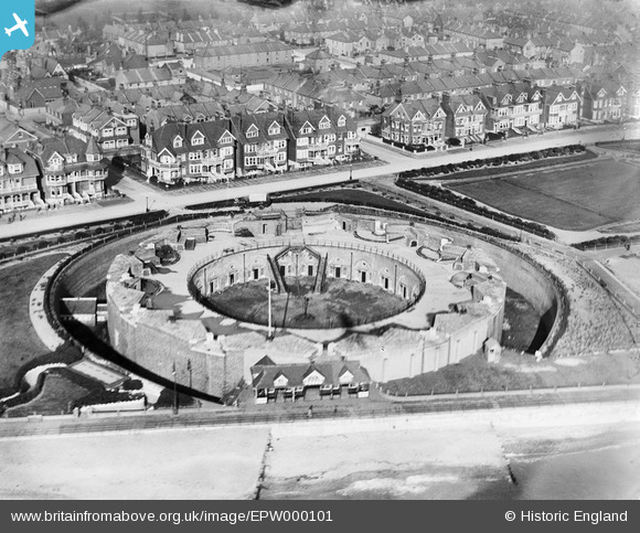
EPW000101 ENGLAND (1920). The Redoubt Fort, Eastbourne, 1920
© Copyright OpenStreetMap contributors and licensed by the OpenStreetMap Foundation. 2026. Cartography is licensed as CC BY-SA.
Nearby Images (8)
EPW000101

EPW042973

EPW039414

EPW051367

EPW000102

EPW051368

EPW039416

EPW000076

Details
| Title | [EPW000101] The Redoubt Fort, Eastbourne, 1920 |
| Reference | EPW000101 |
| Date | February-1920 |
| Link | |
| Place name | EASTBOURNE |
| Parish | |
| District | |
| Country | ENGLAND |
| Easting / Northing | 562278, 99708 |
| Longitude / Latitude | 0.30181846874272, 50.773654617105 |
| National Grid Reference | TV623997 |
Pins

Lancaster |
Wednesday 28th of September 2022 12:34:12 PM | |
|
Lancaster |
Wednesday 28th of September 2022 12:31:31 PM | |

bescotbeast |
Saturday 1st of March 2014 01:58:28 AM |
User Comment Contributions

The superb Redoubt Fortress and Royal Parade behind it looking almost exactly the same then as it does now with the sea washing up close to the footpath in front of it. The Redoubt Fortress was built to deter Napoleon's forces along with the Martello Towers in the early 1800's. The fortress now houses a great museum of the Royal Sussex Regiment. http://www.eastbournemuseums.co.uk/ |
former user |
Friday 29th of June 2012 10:01:46 AM |