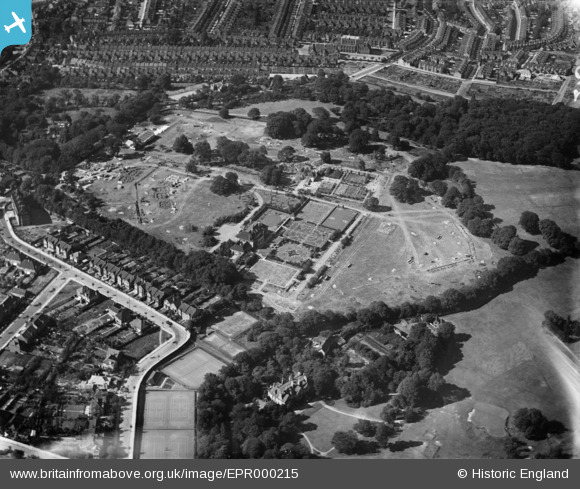
EPR000215 ENGLAND (1934). The Shrewsbury Park Estate under construction, Shooters Hill, 1934
© Copyright OpenStreetMap contributors and licensed by the OpenStreetMap Foundation. 2025. Cartography is licensed as CC BY-SA.
Nearby Images (11)
Details
| Title | [EPR000215] The Shrewsbury Park Estate under construction, Shooters Hill, 1934 |
| Reference | EPR000215 |
| Date | 17-July-1934 |
| Link | |
| Place name | SHOOTERS HILL |
| Parish | |
| District | |
| Country | ENGLAND |
| Easting / Northing | 544097, 177008 |
| Longitude / Latitude | 0.07502714325665, 51.473173319959 |
| National Grid Reference | TQ441770 |
Pins
Be the first to add a comment to this image!


![[EPR000215] The Shrewsbury Park Estate under construction, Shooters Hill, 1934](http://britainfromabove.org.uk/sites/all/libraries/aerofilms-images/public/100x100/EPR/000/EPR000215.jpg)
![[EPR000120] Shrewsbury House, Shooters Hill Golf Club and environs, Shooters Hill, 1934](http://britainfromabove.org.uk/sites/all/libraries/aerofilms-images/public/100x100/EPR/000/EPR000120.jpg)
![[EPR000214] The Shrewsbury Park Estate under construction, Shooters Hill, 1934](http://britainfromabove.org.uk/sites/all/libraries/aerofilms-images/public/100x100/EPR/000/EPR000214.jpg)
![[EPR000219] Eaglesfield Road, Cleanthus Road and the Shrewsbury Park Estate under construction, Shooters Hill, 1934](http://britainfromabove.org.uk/sites/all/libraries/aerofilms-images/public/100x100/EPR/000/EPR000219.jpg)
![[EPR000216] Eaglesfield Road and the Shrewsbury Park Estate under construction, Shooters Hill, 1934](http://britainfromabove.org.uk/sites/all/libraries/aerofilms-images/public/100x100/EPR/000/EPR000216.jpg)
![[EPR000126] Construction of housing around Moordown, Shrewsbury Park and environs, Shooters Hill, 1934](http://britainfromabove.org.uk/sites/all/libraries/aerofilms-images/public/100x100/EPR/000/EPR000126.jpg)
![[EPR000217] The Shrewsbury Park Estate under construction, Shooters Hill, 1934](http://britainfromabove.org.uk/sites/all/libraries/aerofilms-images/public/100x100/EPR/000/EPR000217.jpg)
![[EPR000123] Eaglesfield Road, Shrewsbury Park and environs, Shooters Hill, 1934](http://britainfromabove.org.uk/sites/all/libraries/aerofilms-images/public/100x100/EPR/000/EPR000123.jpg)
![[EPR000218] Eaglesfield Road and the Shrewsbury Park Estate under construction, Shooters Hill, 1934](http://britainfromabove.org.uk/sites/all/libraries/aerofilms-images/public/100x100/EPR/000/EPR000218.jpg)
![[EPR000124] Construction of housing around Moordown, Shrewsbury Park and environs, Shooters Hill, 1934](http://britainfromabove.org.uk/sites/all/libraries/aerofilms-images/public/100x100/EPR/000/EPR000124.jpg)
![[EPR000122] Shrewsbury Park and environs, Shooters Hill, 1934](http://britainfromabove.org.uk/sites/all/libraries/aerofilms-images/public/100x100/EPR/000/EPR000122.jpg)