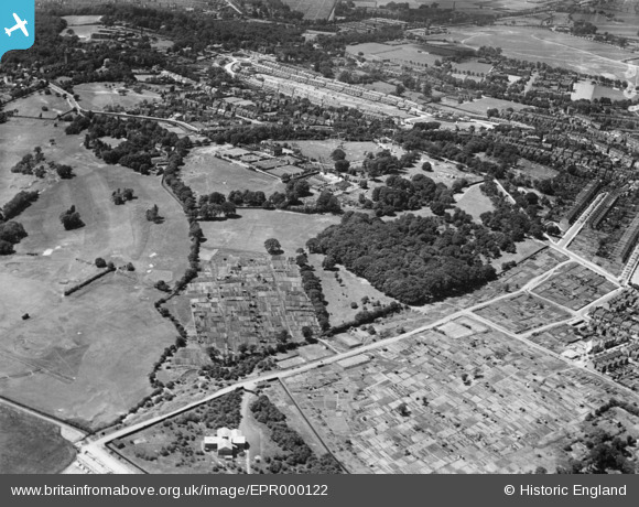
EPR000122 ENGLAND (1934). Shrewsbury Park and environs, Shooters Hill, 1934
© Copyright OpenStreetMap contributors and licensed by the OpenStreetMap Foundation. 2025. Cartography is licensed as CC BY-SA.
Details
| Title | [EPR000122] Shrewsbury Park and environs, Shooters Hill, 1934 |
| Reference | EPR000122 |
| Date | 4-July-1934 |
| Link | |
| Place name | SHOOTERS HILL |
| Parish | |
| District | |
| Country | ENGLAND |
| Easting / Northing | 544342, 177169 |
| Longitude / Latitude | 0.078618484112521, 51.474557705855 |
| National Grid Reference | TQ443772 |
Pins

John W |
Friday 14th of April 2017 05:03:39 PM | |

John W |
Friday 14th of April 2017 04:51:26 PM | |

John W |
Friday 14th of April 2017 04:50:51 PM | |

John W |
Friday 14th of April 2017 04:50:12 PM | |

John W |
Friday 14th of April 2017 04:49:38 PM | |

John W |
Saturday 18th of June 2016 10:00:12 PM | |

John W |
Saturday 18th of June 2016 09:58:59 PM | |

John W |
Saturday 18th of June 2016 09:57:54 PM | |

John W |
Saturday 18th of June 2016 09:56:20 PM | |

John W |
Saturday 18th of June 2016 09:55:34 PM | |

John W |
Saturday 18th of June 2016 09:54:19 PM |


![[EPR000122] Shrewsbury Park and environs, Shooters Hill, 1934](http://britainfromabove.org.uk/sites/all/libraries/aerofilms-images/public/100x100/EPR/000/EPR000122.jpg)
![[EPR000125] Shooters Hill Golf Course, Shrewsbury Park and environs, Shooters Hill, from the east, 1934](http://britainfromabove.org.uk/sites/all/libraries/aerofilms-images/public/100x100/EPR/000/EPR000125.jpg)
![[EPR000215] The Shrewsbury Park Estate under construction, Shooters Hill, 1934](http://britainfromabove.org.uk/sites/all/libraries/aerofilms-images/public/100x100/EPR/000/EPR000215.jpg)