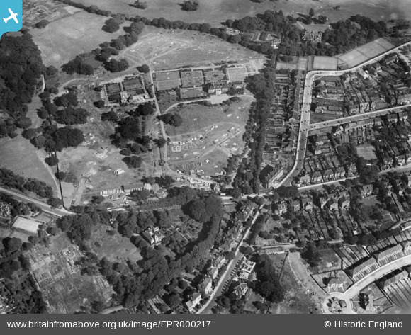
EPR000217 ENGLAND (1934). The Shrewsbury Park Estate under construction, Shooters Hill, 1934
© Copyright OpenStreetMap contributors and licensed by the OpenStreetMap Foundation. 2025. Cartography is licensed as CC BY-SA.
Nearby Images (10)
Details
| Title | [EPR000217] The Shrewsbury Park Estate under construction, Shooters Hill, 1934 |
| Reference | EPR000217 |
| Date | 17-July-1934 |
| Link | |
| Place name | SHOOTERS HILL |
| Parish | |
| District | |
| Country | ENGLAND |
| Easting / Northing | 543979, 177011 |
| Longitude / Latitude | 0.073330337817638, 51.473230325205 |
| National Grid Reference | TQ440770 |
Pins

John W |
Friday 14th of April 2017 04:43:00 PM | |

John W |
Friday 14th of April 2017 04:42:29 PM | |

John W |
Saturday 18th of June 2016 10:08:55 PM | |

John W |
Saturday 18th of June 2016 10:03:48 PM | |

John W |
Saturday 18th of June 2016 10:03:10 PM | |

RichMoly |
Sunday 11th of January 2015 01:44:22 PM | |

RichMoly |
Sunday 11th of January 2015 01:43:27 PM | |

RichMoly |
Sunday 11th of January 2015 01:36:22 PM | |
May I respectfully point out that at the time the photograph was taken, this fire station was in active service. Built 1912 for the LCC, it closed in the 1980s. |

John W |
Saturday 18th of June 2016 10:14:16 PM |


![[EPR000217] The Shrewsbury Park Estate under construction, Shooters Hill, 1934](http://britainfromabove.org.uk/sites/all/libraries/aerofilms-images/public/100x100/EPR/000/EPR000217.jpg)
![[EPR000218] Eaglesfield Road and the Shrewsbury Park Estate under construction, Shooters Hill, 1934](http://britainfromabove.org.uk/sites/all/libraries/aerofilms-images/public/100x100/EPR/000/EPR000218.jpg)
![[EPR000216] Eaglesfield Road and the Shrewsbury Park Estate under construction, Shooters Hill, 1934](http://britainfromabove.org.uk/sites/all/libraries/aerofilms-images/public/100x100/EPR/000/EPR000216.jpg)
![[EPR000123] Eaglesfield Road, Shrewsbury Park and environs, Shooters Hill, 1934](http://britainfromabove.org.uk/sites/all/libraries/aerofilms-images/public/100x100/EPR/000/EPR000123.jpg)
![[EPR000219] Eaglesfield Road, Cleanthus Road and the Shrewsbury Park Estate under construction, Shooters Hill, 1934](http://britainfromabove.org.uk/sites/all/libraries/aerofilms-images/public/100x100/EPR/000/EPR000219.jpg)
![[EPR000126] Construction of housing around Moordown, Shrewsbury Park and environs, Shooters Hill, 1934](http://britainfromabove.org.uk/sites/all/libraries/aerofilms-images/public/100x100/EPR/000/EPR000126.jpg)
![[EPR000120] Shrewsbury House, Shooters Hill Golf Club and environs, Shooters Hill, 1934](http://britainfromabove.org.uk/sites/all/libraries/aerofilms-images/public/100x100/EPR/000/EPR000120.jpg)
![[EPR000124] Construction of housing around Moordown, Shrewsbury Park and environs, Shooters Hill, 1934](http://britainfromabove.org.uk/sites/all/libraries/aerofilms-images/public/100x100/EPR/000/EPR000124.jpg)
![[EPR000215] The Shrewsbury Park Estate under construction, Shooters Hill, 1934](http://britainfromabove.org.uk/sites/all/libraries/aerofilms-images/public/100x100/EPR/000/EPR000215.jpg)
![[EPR000214] The Shrewsbury Park Estate under construction, Shooters Hill, 1934](http://britainfromabove.org.uk/sites/all/libraries/aerofilms-images/public/100x100/EPR/000/EPR000214.jpg)