
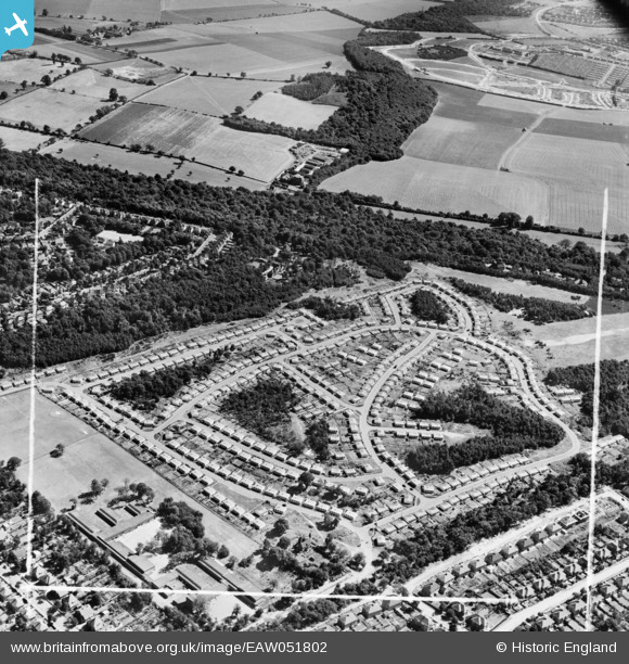
EAW051802 ENGLAND (1953). The Shrublands estate of prefabricated houses on land previously forming part of Addington Golf Course, Shirley, 1953. This image was marked by Aerofilms Ltd for photo editing.
© Copyright OpenStreetMap contributors and licensed by the OpenStreetMap Foundation. 2026. Cartography is licensed as CC BY-SA.
Nearby Images (23)
EAW051802

EAW002098

EAW051806

EAW004324

EAW002091

EAW051808

EAW004322

EAW002099

EAW002093

EAW002094

EAW002090

EAW002096

EAW004323

EAW051805

EAW004320

EAW004318

EAW002089

EAW002095

EAW002097

EAW051809

EAW051804

EAW004319

EAW051810

Details
| Title | [EAW051802] The Shrublands estate of prefabricated houses on land previously forming part of Addington Golf Course, Shirley, 1953. This image was marked by Aerofilms Ltd for photo editing. |
| Reference | EAW051802 |
| Date | 1-September-1953 |
| Link | |
| Place name | SHIRLEY |
| Parish | |
| District | |
| Country | ENGLAND |
| Easting / Northing | 537540, 164946 |
| Longitude / Latitude | -0.024014831946668, 51.366401236799 |
| National Grid Reference | TQ375649 |
Pins

Peter Byford |
Sunday 10th of May 2020 09:23:35 PM | |
|
Peter Byford |
Sunday 10th of May 2020 08:52:32 PM |