
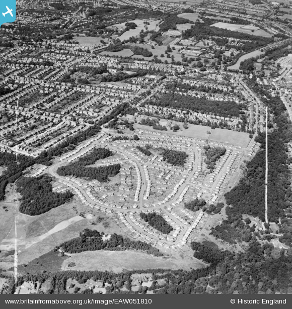
EAW051810 ENGLAND (1953). The Shrublands estate of prefabricated houses on land previously forming part of Addington Golf Course, Shirley, 1953. This image was marked by Aerofilms Ltd for photo editing.
© Copyright OpenStreetMap contributors and licensed by the OpenStreetMap Foundation. 2026. Cartography is licensed as CC BY-SA.
Nearby Images (18)
EAW051810

EAW004316

EAW051803

EAW004318

EAW002097

EAW051805

EAW002090

EAW002094

EAW002093

EAW002089

EAW004322

EAW002091

EAW051807

EAW004317

EAW002099

EAW004323

EAW002098

EAW051802

Details
| Title | [EAW051810] The Shrublands estate of prefabricated houses on land previously forming part of Addington Golf Course, Shirley, 1953. This image was marked by Aerofilms Ltd for photo editing. |
| Reference | EAW051810 |
| Date | 1-September-1953 |
| Link | |
| Place name | SHIRLEY |
| Parish | |
| District | |
| Country | ENGLAND |
| Easting / Northing | 537316, 165170 |
| Longitude / Latitude | -0.027144365133151, 51.368468621108 |
| National Grid Reference | TQ373652 |
Pins

Terry the Carpet Estimator |
Thursday 30th of June 2016 03:04:00 PM | |
|
Terry the Carpet Estimator |
Thursday 30th of June 2016 03:02:59 PM |
User Comment Contributions
The prefab estate was not known as Shrublands until it was demolished by Croydon Council in 1959-61 destroying a wonderful close knit community and rebuilt with council houses and flats which I later lived on from 1962-1976. I lived on the prefab estate from 1948-1960 and visited every prefab with my father as he was the estate's Tally Man.We knew every occupier. |
Terry the Carpet Estimator |
Thursday 30th of June 2016 03:15:14 PM |