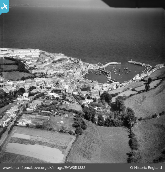
EAW051332 ENGLAND (1953). The village and harbour, Mevagissey, 1953
© Copyright OpenStreetMap contributors and licensed by the OpenStreetMap Foundation. 2026. Cartography is licensed as CC BY-SA.
Nearby Images (12)
Details
| Title | [EAW051332] The village and harbour, Mevagissey, 1953 |
| Reference | EAW051332 |
| Date | 11-August-1953 |
| Link | |
| Place name | MEVAGISSEY |
| Parish | MEVAGISSEY |
| District | |
| Country | ENGLAND |
| Easting / Northing | 201462, 44825 |
| Longitude / Latitude | -4.7863441205371, 50.269349008577 |
| National Grid Reference | SX015448 |
Pins
Be the first to add a comment to this image!


![[EAW051332] The village and harbour, Mevagissey, 1953](http://britainfromabove.org.uk/sites/all/libraries/aerofilms-images/public/100x100/EAW/051/EAW051332.jpg)
![[EAW040863] The Harbour and the village, Mevagissey, 1951](http://britainfromabove.org.uk/sites/all/libraries/aerofilms-images/public/100x100/EAW/040/EAW040863.jpg)
![[EAW021377] The Pool and the village, Mevagissey, 1949. This image has been produced from a print.](http://britainfromabove.org.uk/sites/all/libraries/aerofilms-images/public/100x100/EAW/021/EAW021377.jpg)
![[EPW021706] The Pool and Harbour, Mevagissey, 1928](http://britainfromabove.org.uk/sites/all/libraries/aerofilms-images/public/100x100/EPW/021/EPW021706.jpg)
![[EAW131420] Village and harbour, Mevagissey, 1964](http://britainfromabove.org.uk/sites/all/libraries/aerofilms-images/public/100x100/EAW/131/EAW131420.jpg)
![[EAW053026] The village and harbour, Mevagissey, 1953](http://britainfromabove.org.uk/sites/all/libraries/aerofilms-images/public/100x100/EAW/053/EAW053026.jpg)
![[EPW021707] The Pool and Harbour, Mevagissey, 1928](http://britainfromabove.org.uk/sites/all/libraries/aerofilms-images/public/100x100/EPW/021/EPW021707.jpg)
![[EPW021708] The Pool and Harbour, Mevagissey, 1928](http://britainfromabove.org.uk/sites/all/libraries/aerofilms-images/public/100x100/EPW/021/EPW021708.jpg)
![[EAW051334] The village and harbour, Mevagissey, 1953](http://britainfromabove.org.uk/sites/all/libraries/aerofilms-images/public/100x100/EAW/051/EAW051334.jpg)
![[EAW051336] The village, North Pier and the harbour, Mevagissey, 1953](http://britainfromabove.org.uk/sites/all/libraries/aerofilms-images/public/100x100/EAW/051/EAW051336.jpg)
![[EAW277586] Village and harbour, Mevagissey, 1974](http://britainfromabove.org.uk/sites/all/libraries/aerofilms-images/public/100x100/EAW/277/EAW277586.jpg)
![[EAW051333] The village and harbour, Mevagissey, 1953](http://britainfromabove.org.uk/sites/all/libraries/aerofilms-images/public/100x100/EAW/051/EAW051333.jpg)