
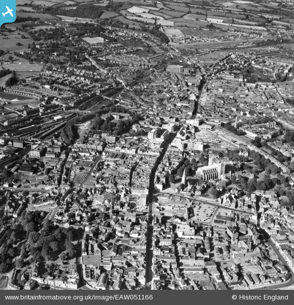
EAW051166 ENGLAND (1953). The city centre, Exeter, 1953
© Copyright OpenStreetMap contributors and licensed by the OpenStreetMap Foundation. 2026. Cartography is licensed as CC BY-SA.
Nearby Images (29)
EAW051166

EAW005857

EAW005856

EAW051163

EAW003660

EPW003660

EAW051161

EAW003659

EPW003659

EAW005853

EAW051162

EAW051167

EPW003657

EPW024104

EAW051168

EAW051172

EAW051165

EAW005854

EPW024108

EAW005852

EPW041169

EPW024105

EPW024083

EPW024084

EAW051169

EAW003658

EPW003658

EPW024132

EPW024109

Details
| Title | [EAW051166] The city centre, Exeter, 1953 |
| Reference | EAW051166 |
| Date | 6-August-1953 |
| Link | |
| Place name | EXETER |
| Parish | |
| District | |
| Country | ENGLAND |
| Easting / Northing | 292064, 92771 |
| Longitude / Latitude | -3.5293425873991, 50.723951348038 |
| National Grid Reference | SX921928 |
Pins

David |
Friday 20th of May 2022 04:56:45 PM | |

Chas Drown |
Thursday 13th of November 2014 04:41:16 PM | |
|
Chas Drown |
Thursday 13th of November 2014 04:39:17 PM | |
|
Chas Drown |
Thursday 13th of November 2014 04:37:09 PM |