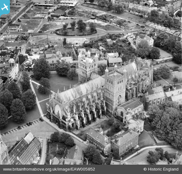
EAW005852 ENGLAND (1947). St Peter's Cathedral, Exeter, 1947
© Copyright OpenStreetMap contributors and licensed by the OpenStreetMap Foundation. 2026. Cartography is licensed as CC BY-SA.
Nearby Images (32)
Details
| Title | [EAW005852] St Peter's Cathedral, Exeter, 1947 |
| Reference | EAW005852 |
| Date | 18-May-1947 |
| Link | |
| Place name | EXETER |
| Parish | |
| District | |
| Country | ENGLAND |
| Easting / Northing | 292092, 92550 |
| Longitude / Latitude | -3.5288813351191, 50.721969649716 |
| National Grid Reference | SX921926 |
Pins

Kentishman |
Thursday 26th of April 2018 10:53:50 AM | |

Kentishman |
Thursday 26th of April 2018 10:47:06 AM | |

Kentishman |
Thursday 26th of April 2018 10:43:19 AM | |

Kentishman |
Thursday 26th of April 2018 10:41:57 AM | |

Billy Turner |
Sunday 30th of October 2016 02:32:12 PM | |

Goldenhammerman |
Friday 21st of February 2014 03:49:26 PM |
User Comment Contributions

West front of cathedral, 19/06/2013 |

Class31 |
Saturday 9th of April 2016 07:06:31 AM |


![[EAW005852] St Peter's Cathedral, Exeter, 1947](http://britainfromabove.org.uk/sites/all/libraries/aerofilms-images/public/100x100/EAW/005/EAW005852.jpg)
![[EPW024108] St Peter's Cathedral, Exeter, 1928](http://britainfromabove.org.uk/sites/all/libraries/aerofilms-images/public/100x100/EPW/024/EPW024108.jpg)
![[EAW005854] St Peter's Cathedral and the city centre, Exeter, 1947](http://britainfromabove.org.uk/sites/all/libraries/aerofilms-images/public/100x100/EAW/005/EAW005854.jpg)
![[EAW051168] High Street, Bedford Street and the city centre, Exeter, 1953](http://britainfromabove.org.uk/sites/all/libraries/aerofilms-images/public/100x100/EAW/051/EAW051168.jpg)
![[EPW024105] St Peter's Cathedral, Exeter, 1928](http://britainfromabove.org.uk/sites/all/libraries/aerofilms-images/public/100x100/EPW/024/EPW024105.jpg)
![[EPW041169] Exeter Cathedral, Exeter, 1933](http://britainfromabove.org.uk/sites/all/libraries/aerofilms-images/public/100x100/EPW/041/EPW041169.jpg)
![[EPW024084] St Peter's Cathedral, Exeter, 1928](http://britainfromabove.org.uk/sites/all/libraries/aerofilms-images/public/100x100/EPW/024/EPW024084.jpg)
![[EPW024083] St Peter's Cathedral, Exeter, 1928](http://britainfromabove.org.uk/sites/all/libraries/aerofilms-images/public/100x100/EPW/024/EPW024083.jpg)
![[EAW051164] The city centre, Exeter, 1953](http://britainfromabove.org.uk/sites/all/libraries/aerofilms-images/public/100x100/EAW/051/EAW051164.jpg)
![[EAW051167] The city centre, Exeter, 1953](http://britainfromabove.org.uk/sites/all/libraries/aerofilms-images/public/100x100/EAW/051/EAW051167.jpg)
![[EPW003657] St Peter's Cathedral and the city centre, Exeter, 1930s](http://britainfromabove.org.uk/sites/all/libraries/aerofilms-images/public/100x100/EPW/003/EPW003657.jpg)
![[EAW003659] The city centre, Exeter, 1930s](http://britainfromabove.org.uk/sites/all/libraries/aerofilms-images/public/100x100/EAW/003/EAW003659.jpg)
![[EPW003659] The city centre, Exeter, 1930s](http://britainfromabove.org.uk/sites/all/libraries/aerofilms-images/public/100x100/EPW/003/EPW003659.jpg)
![[EAW005853] The city centre, Exeter, 1947](http://britainfromabove.org.uk/sites/all/libraries/aerofilms-images/public/100x100/EAW/005/EAW005853.jpg)
![[EAW051162] St Peter's Cathedral and the city centre, Exeter, 1953](http://britainfromabove.org.uk/sites/all/libraries/aerofilms-images/public/100x100/EAW/051/EAW051162.jpg)
![[EAW051163] The city centre, Exeter, 1953](http://britainfromabove.org.uk/sites/all/libraries/aerofilms-images/public/100x100/EAW/051/EAW051163.jpg)
![[EAW051165] The city centre, Exeter, 1953](http://britainfromabove.org.uk/sites/all/libraries/aerofilms-images/public/100x100/EAW/051/EAW051165.jpg)
![[EAW051169] The site of Bedford Circus and the city centre, Exeter, 1953](http://britainfromabove.org.uk/sites/all/libraries/aerofilms-images/public/100x100/EAW/051/EAW051169.jpg)
![[EPW024104] Bedford Circus, Exeter, 1928](http://britainfromabove.org.uk/sites/all/libraries/aerofilms-images/public/100x100/EPW/024/EPW024104.jpg)
![[EAW005858] The city, Exeter, 1947](http://britainfromabove.org.uk/sites/all/libraries/aerofilms-images/public/100x100/EAW/005/EAW005858.jpg)
![[EAW051166] The city centre, Exeter, 1953](http://britainfromabove.org.uk/sites/all/libraries/aerofilms-images/public/100x100/EAW/051/EAW051166.jpg)
![[EAW003658] St Peter's Cathedral, Bedford Circus and the city centre, Exeter, 1930s](http://britainfromabove.org.uk/sites/all/libraries/aerofilms-images/public/100x100/EAW/003/EAW003658.jpg)
![[EPW003658] St Peter's Cathedral, Bedford Circus and the city centre, Exeter, 1930s](http://britainfromabove.org.uk/sites/all/libraries/aerofilms-images/public/100x100/EPW/003/EPW003658.jpg)
![[EAW005856] The city, Exeter, from the north, 1947](http://britainfromabove.org.uk/sites/all/libraries/aerofilms-images/public/100x100/EAW/005/EAW005856.jpg)
![[EAW005857] The city, Exeter, 1947](http://britainfromabove.org.uk/sites/all/libraries/aerofilms-images/public/100x100/EAW/005/EAW005857.jpg)
![[EAW051161] Exeter Castle, St Peter's Cathedral and the surrounding area, Exeter, 1953](http://britainfromabove.org.uk/sites/all/libraries/aerofilms-images/public/100x100/EAW/051/EAW051161.jpg)
![[EAW051170] The site of Bedford Circus and the city centre, Exeter, 1953](http://britainfromabove.org.uk/sites/all/libraries/aerofilms-images/public/100x100/EAW/051/EAW051170.jpg)
![[EAW003657] St Peter's Cathedral and the city centre, Exeter, 1930s](http://britainfromabove.org.uk/sites/all/libraries/aerofilms-images/public/100x100/EAW/003/EAW003657.jpg)
![[EAW003660] St Peter's Cathedral and the city centre, Exeter, 1930s](http://britainfromabove.org.uk/sites/all/libraries/aerofilms-images/public/100x100/EAW/003/EAW003660.jpg)
![[EPW003660] St Peter's Cathedral and the city centre, Exeter, 1930s](http://britainfromabove.org.uk/sites/all/libraries/aerofilms-images/public/100x100/EPW/003/EPW003660.jpg)
![[EAW051172] The High Street and city centre, Exeter, 1953](http://britainfromabove.org.uk/sites/all/libraries/aerofilms-images/public/100x100/EAW/051/EAW051172.jpg)
![[EPW024103] Bedford Circus and environs, Exeter, from the east, 1928](http://britainfromabove.org.uk/sites/all/libraries/aerofilms-images/public/100x100/EPW/024/EPW024103.jpg)
