
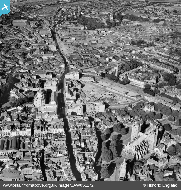
EAW051172 ENGLAND (1953). The High Street and city centre, Exeter, 1953
© Copyright OpenStreetMap contributors and licensed by the OpenStreetMap Foundation. 2026. Cartography is licensed as CC BY-SA.
Nearby Images (30)
EAW051172

EPW024104

EPW024103

EAW051165

EAW051170

EAW051161

EPW041170

EAW003658

EPW003658

EAW051171

EAW051169

EPW024132

EAW005853

EAW051163

EAW051160

EPW024109

EAW051167

EAW005857

EAW051166

EAW003659

EPW003659

EAW005856

EAW051168

EAW005854

EPW024083

EAW005852

EPW024108

EPW041169

EPW024105

EPW024084

Details
| Title | [EAW051172] The High Street and city centre, Exeter, 1953 |
| Reference | EAW051172 |
| Date | 6-August-1953 |
| Link | |
| Place name | EXETER |
| Parish | |
| District | |
| Country | ENGLAND |
| Easting / Northing | 292269, 92760 |
| Longitude / Latitude | -3.5264358342212, 50.723890507361 |
| National Grid Reference | SX923928 |
Pins

Chas Drown |
Wednesday 22nd of January 2020 03:18:53 PM | |

Scooby |
Friday 17th of January 2020 04:23:21 PM | |
|
joepettetsmith |
Thursday 20th of October 2016 07:02:09 PM | |
|
markypiper |
Saturday 21st of November 2015 08:58:42 PM | |
Allen T |
Thursday 27th of November 2014 03:32:09 PM | |
Allen T |
Thursday 27th of November 2014 03:30:43 PM | |
Allen T |
Thursday 27th of November 2014 03:29:08 PM | |
Allen T |
Thursday 27th of November 2014 03:27:49 PM | |
Allen T |
Thursday 27th of November 2014 03:25:53 PM | |
Allen T |
Thursday 27th of November 2014 03:25:05 PM | |
Allen T |
Thursday 27th of November 2014 03:23:20 PM | |
Allen T |
Thursday 27th of November 2014 12:27:02 PM | |
Allen T |
Thursday 27th of November 2014 12:25:44 PM | |
Allen T |
Thursday 27th of November 2014 12:20:11 PM | |
Allen T |
Thursday 27th of November 2014 12:19:05 PM | |
Allen T |
Thursday 27th of November 2014 12:18:18 PM | |
Allen T |
Thursday 27th of November 2014 12:17:10 PM | |
Allen T |
Thursday 27th of November 2014 11:40:28 AM | |
Allen T |
Thursday 27th of November 2014 11:27:51 AM | |
Allen T |
Thursday 27th of November 2014 11:25:48 AM | |
Allen T |
Thursday 27th of November 2014 11:25:05 AM | |
Allen T |
Thursday 27th of November 2014 11:03:10 AM | |
Allen T |
Thursday 27th of November 2014 11:01:12 AM | |
Allen T |
Thursday 27th of November 2014 11:00:28 AM |