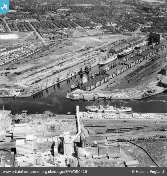
EAW050418 ENGLAND (1953). No. 9 Dock and environs, Salford, 1953
© Copyright OpenStreetMap contributors and licensed by the OpenStreetMap Foundation. 2026. Cartography is licensed as CC BY-SA.
Nearby Images (17)
Details
| Title | [EAW050418] No. 9 Dock and environs, Salford, 1953 |
| Reference | EAW050418 |
| Date | 7-July-1953 |
| Link | |
| Place name | SALFORD |
| Parish | |
| District | |
| Country | ENGLAND |
| Easting / Northing | 380443, 397215 |
| Longitude / Latitude | -2.2946609360491, 53.471052988598 |
| National Grid Reference | SJ804972 |
Pins

John T. Pitman |
Sunday 20th of September 2015 10:44:53 PM |


![[EAW050418] No. 9 Dock and environs, Salford, 1953](http://britainfromabove.org.uk/sites/all/libraries/aerofilms-images/public/100x100/EAW/050/EAW050418.jpg)
![[EPW028011] Salford Docks, Salford, 1929](http://britainfromabove.org.uk/sites/all/libraries/aerofilms-images/public/100x100/EPW/028/EPW028011.jpg)
![[EAW017329] The Manchester Ship Canal and entrance to No 9 Dock, Salford, 1948. This image has been produced from a print.](http://britainfromabove.org.uk/sites/all/libraries/aerofilms-images/public/100x100/EAW/017/EAW017329.jpg)
![[EPW028012] Salford Docks, Salford, 1929](http://britainfromabove.org.uk/sites/all/libraries/aerofilms-images/public/100x100/EPW/028/EPW028012.jpg)
![[EPW028013] Salford Docks, Salford, 1929](http://britainfromabove.org.uk/sites/all/libraries/aerofilms-images/public/100x100/EPW/028/EPW028013.jpg)
![[EPW028149] Salford Docks, Salford, 1929. This image has been produced from a copy-negative.](http://britainfromabove.org.uk/sites/all/libraries/aerofilms-images/public/100x100/EPW/028/EPW028149.jpg)
![[EPW027854] The Salford Docks and the Manchester Ship Canal, Salford, 1929](http://britainfromabove.org.uk/sites/all/libraries/aerofilms-images/public/100x100/EPW/027/EPW027854.jpg)
![[EPW027729] Salford Docks, Salford, 1929. This image has been produced from a print affected by flare.](http://britainfromabove.org.uk/sites/all/libraries/aerofilms-images/public/100x100/EPW/027/EPW027729.jpg)
![[EPW017596] No. 9 Dock, Salford Quays, 1927](http://britainfromabove.org.uk/sites/all/libraries/aerofilms-images/public/100x100/EPW/017/EPW017596.jpg)
![[EPW045987] The Timber Yard and Number 9 Dock of Manchester Docks, Salford, 1934](http://britainfromabove.org.uk/sites/all/libraries/aerofilms-images/public/100x100/EPW/045/EPW045987.jpg)
![[EAW050419] No. 9 Dock and environs, Salford, 1953](http://britainfromabove.org.uk/sites/all/libraries/aerofilms-images/public/100x100/EAW/050/EAW050419.jpg)
![[EPW028015] No. 9 Dock at Salford Quays, Salford, 1929](http://britainfromabove.org.uk/sites/all/libraries/aerofilms-images/public/100x100/EPW/028/EPW028015.jpg)
![[EAW000804] Salford Docks, Salford, 1946](http://britainfromabove.org.uk/sites/all/libraries/aerofilms-images/public/100x100/EAW/000/EAW000804.jpg)
![[EPW027857] The Salford Docks, Salford, 1929](http://britainfromabove.org.uk/sites/all/libraries/aerofilms-images/public/100x100/EPW/027/EPW027857.jpg)
![[EPW027860] The Salford Docks and the Manchester Ship Canal, Salford, 1929](http://britainfromabove.org.uk/sites/all/libraries/aerofilms-images/public/100x100/EPW/027/EPW027860.jpg)
![[EPW027784] The Hovis flour mills and Grain Elevator alongside the Manchester Ship Canal, Old Trafford, 1929](http://britainfromabove.org.uk/sites/all/libraries/aerofilms-images/public/100x100/EPW/027/EPW027784.jpg)
![[EAW017318] The British Oil and Cake Mills Ltd Trafford Oil Mill and environs, Trafford Park, 1948. This image has been produced from a print marked by Aerofilms Ltd for photo editing.](http://britainfromabove.org.uk/sites/all/libraries/aerofilms-images/public/100x100/EAW/017/EAW017318.jpg)