
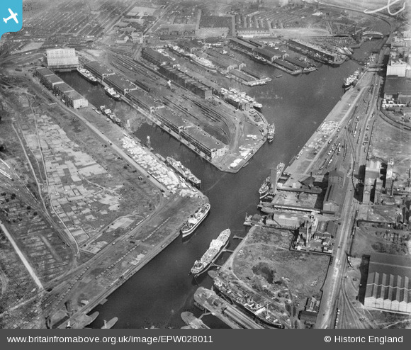
EPW028011 ENGLAND (1929). Salford Docks, Salford, 1929
© Copyright OpenStreetMap contributors and licensed by the OpenStreetMap Foundation. 2026. Cartography is licensed as CC BY-SA.
Nearby Images (14)
EPW028011

EAW050418

EAW017329

EPW028013

EPW028012

EPW027854

EPW028149

EPW027729

EAW050419

EPW017596

EPW045987

EPW028015

EPW027784

EAW017318

Details
| Title | [EPW028011] Salford Docks, Salford, 1929 |
| Reference | EPW028011 |
| Date | July-1929 |
| Link | |
| Place name | SALFORD |
| Parish | |
| District | |
| Country | ENGLAND |
| Easting / Northing | 380416, 397222 |
| Longitude / Latitude | -2.2950681695282, 53.471114910577 |
| National Grid Reference | SJ804972 |
Pins

smartie148 |
Sunday 15th of November 2020 04:56:57 PM | |
 |
Paul Marks |
Thursday 6th of December 2012 01:49:40 PM |
User Comment Contributions
Photograph of The Lowry - Rob Chafer |
Paul Marks |
Thursday 6th of December 2012 01:50:57 PM |