
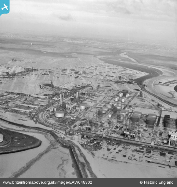
EAW048302 ENGLAND (1953). Flooding at the Coryton Oil Refinery, Coryton, from the south-east, 1953
© Copyright OpenStreetMap contributors and licensed by the OpenStreetMap Foundation. 2026. Cartography is licensed as CC BY-SA.
Nearby Images (48)
EAW048302

EAW039881

EAW047435

EAW034436

EAW048089

EAW039891

EAW048102

EAW034403

EAW039892

EAW043890

EAW034409

EAW035774

EAW043889

EAW045734

EAW048095

EAW048106

EAW048592

EAW048587

EAW048091

EAW045730

EAW051374

EAW034435

EAW045733

EAW048588

EAW043886

EAW024608

EAW039893

EAW039884

EAW051371

EAW047422

EAW042272

EAW035778

EAW041996

EAW035772

EAW048097

EAW034437

EAW042268

EAW043887

EAW043882

EAW048372

EAW048591

EAW042284

EAW047438

EAW043880

EAW048594

EAW053084

EAW035775

EAW048103

Details
| Title | [EAW048302] Flooding at the Coryton Oil Refinery, Coryton, from the south-east, 1953 |
| Reference | EAW048302 |
| Date | 2-February-1953 |
| Link | |
| Place name | CORYTON |
| Parish | |
| District | |
| Country | ENGLAND |
| Easting / Northing | 575055, 182152 |
| Longitude / Latitude | 0.52295690723803, 51.510654866535 |
| National Grid Reference | TQ751822 |
Pins
Be the first to add a comment to this image!