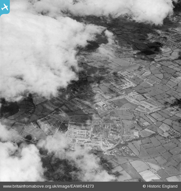
EAW044273 ENGLAND (1952). The town and development to the west of Cowley Hill, Borehamwood, from the east, 1952
    © Copyright OpenStreetMap contributors and licensed by the OpenStreetMap Foundation. 2025. Cartography is licensed as CC BY-SA.
  
Nearby Images (12)
Details
| Title | [EAW044273] The town and development to the west of Cowley Hill, Borehamwood, from the east, 1952 | 
| Reference | EAW044273 | 
| Date | 19-July-1952 | 
| Link | |
| Place name | BOREHAMWOOD | 
| Parish | ELSTREE AND BOREHAMWOOD | 
| District | |
| Country | ENGLAND | 
| Easting / Northing | 520458, 196541 | 
| Longitude / Latitude | -0.25849868944677, 51.654269292078 | 
| National Grid Reference | TQ205965 | 
Pins
Be the first to add a comment to this image!
 
             
  ![[EAW044273] The town and development to the west of Cowley Hill, Borehamwood, from the east, 1952](http://britainfromabove.org.uk/sites/all/libraries/aerofilms-images/public/100x100/EAW/044/EAW044273.jpg) 
  
                                          ![[EAW033382] The area between Elstree Way, Furzehill Road and the Barnet Bypass under development, Borehamwood, 1950.](http://britainfromabove.org.uk/sites/all/libraries/aerofilms-images/public/100x100/EAW/033/EAW033382.jpg) 
 ![[EAW033381] The area between Elstree Way, Furzehill Road and the Barnet Bypass under development, Borehamwood, 1950.](http://britainfromabove.org.uk/sites/all/libraries/aerofilms-images/public/100x100/EAW/033/EAW033381.jpg) 
 ![[EAW045740] Factories and depot between Chester Road and King George's Field, Borehamwood, 1952](http://britainfromabove.org.uk/sites/all/libraries/aerofilms-images/public/100x100/EAW/045/EAW045740.jpg) 
 ![[EAW031640] John Laing and Son Ltd Depot off Chester Road and Featherstone Gardens, Borehamwood, 1950](http://britainfromabove.org.uk/sites/all/libraries/aerofilms-images/public/100x100/EAW/031/EAW031640.jpg) 
 ![[EAW031641] John Laing and Son Ltd Depot off Chester Road, Borehamwood, 1950](http://britainfromabove.org.uk/sites/all/libraries/aerofilms-images/public/100x100/EAW/031/EAW031641.jpg) 
 ![[EAW033383] The area between Elstree Way, Furzehill Road and the Barnet Bypass under development, Borehamwood, 1950. This image has been produced from a print.](http://britainfromabove.org.uk/sites/all/libraries/aerofilms-images/public/100x100/EAW/033/EAW033383.jpg) 
 ![[EAW031637] John Laing and Son Ltd Depot off Chester Road and environs, Borehamwood, 1950](http://britainfromabove.org.uk/sites/all/libraries/aerofilms-images/public/100x100/EAW/031/EAW031637.jpg) 
 ![[EAW031639] John Laing and Son Ltd Depot off Chester Road, Borehamwood, 1950](http://britainfromabove.org.uk/sites/all/libraries/aerofilms-images/public/100x100/EAW/031/EAW031639.jpg) 
 ![[EAW031633] John Laing and Son Ltd Depot off Chester Road, Borehamwood, 1950](http://britainfromabove.org.uk/sites/all/libraries/aerofilms-images/public/100x100/EAW/031/EAW031633.jpg) 
 ![[EAW046960] Penscroft Gardens and environs, Borehamwood, 1952](http://britainfromabove.org.uk/sites/all/libraries/aerofilms-images/public/100x100/EAW/046/EAW046960.jpg) 
 ![[EAW046961] Penscroft Gardens and environs, Borehamwood, 1952](http://britainfromabove.org.uk/sites/all/libraries/aerofilms-images/public/100x100/EAW/046/EAW046961.jpg)