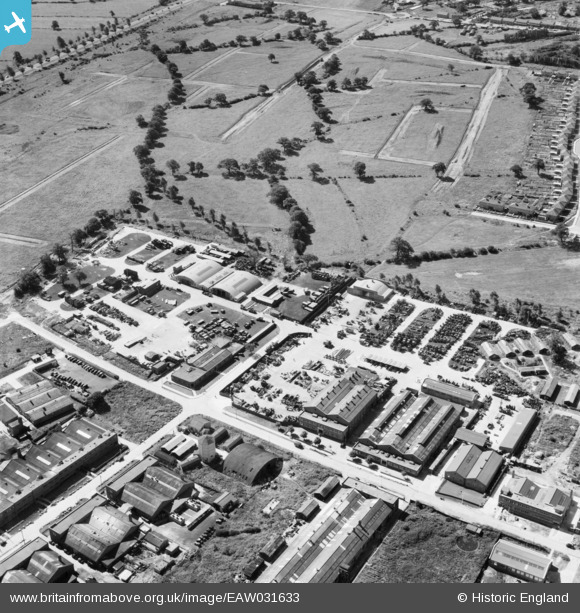
EAW031633 ENGLAND (1950). John Laing and Son Ltd Depot off Chester Road, Borehamwood, 1950
© Copyright OpenStreetMap contributors and licensed by the OpenStreetMap Foundation. 2026. Cartography is licensed as CC BY-SA.
Nearby Images (21)
Details
| Title | [EAW031633] John Laing and Son Ltd Depot off Chester Road, Borehamwood, 1950 |
| Reference | EAW031633 |
| Date | 1-August-1950 |
| Link | |
| Place name | BOREHAMWOOD |
| Parish | ELSTREE AND BOREHAMWOOD |
| District | |
| Country | ENGLAND |
| Easting / Northing | 520700, 196683 |
| Longitude / Latitude | -0.25495273235088, 51.655493682509 |
| National Grid Reference | TQ207967 |
Pins
Be the first to add a comment to this image!


![[EAW031633] John Laing and Son Ltd Depot off Chester Road, Borehamwood, 1950](http://britainfromabove.org.uk/sites/all/libraries/aerofilms-images/public/100x100/EAW/031/EAW031633.jpg)
![[EAW031636] John Laing and Son Ltd Depot off Chester Road, Borehamwood, 1950](http://britainfromabove.org.uk/sites/all/libraries/aerofilms-images/public/100x100/EAW/031/EAW031636.jpg)
![[EAW031643] John Laing and Son Ltd Depot off Chester Road, Borehamwood, 1950](http://britainfromabove.org.uk/sites/all/libraries/aerofilms-images/public/100x100/EAW/031/EAW031643.jpg)
![[EAW031640] John Laing and Son Ltd Depot off Chester Road and Featherstone Gardens, Borehamwood, 1950](http://britainfromabove.org.uk/sites/all/libraries/aerofilms-images/public/100x100/EAW/031/EAW031640.jpg)
![[EAW031639] John Laing and Son Ltd Depot off Chester Road, Borehamwood, 1950](http://britainfromabove.org.uk/sites/all/libraries/aerofilms-images/public/100x100/EAW/031/EAW031639.jpg)
![[EAW031637] John Laing and Son Ltd Depot off Chester Road and environs, Borehamwood, 1950](http://britainfromabove.org.uk/sites/all/libraries/aerofilms-images/public/100x100/EAW/031/EAW031637.jpg)
![[EAW031638] John Laing and Son Ltd Depot off Chester Road, Borehamwood, 1950](http://britainfromabove.org.uk/sites/all/libraries/aerofilms-images/public/100x100/EAW/031/EAW031638.jpg)
![[EAW031635] John Laing and Son Ltd Depot off Chester Road, Borehamwood, 1950](http://britainfromabove.org.uk/sites/all/libraries/aerofilms-images/public/100x100/EAW/031/EAW031635.jpg)
![[EAW031641] John Laing and Son Ltd Depot off Chester Road, Borehamwood, 1950](http://britainfromabove.org.uk/sites/all/libraries/aerofilms-images/public/100x100/EAW/031/EAW031641.jpg)
![[EAW031644] John Laing and Son Ltd Depot off Chester Road and environs, Borehamwood, from the north-east, 1950](http://britainfromabove.org.uk/sites/all/libraries/aerofilms-images/public/100x100/EAW/031/EAW031644.jpg)
![[EAW045740] Factories and depot between Chester Road and King George's Field, Borehamwood, 1952](http://britainfromabove.org.uk/sites/all/libraries/aerofilms-images/public/100x100/EAW/045/EAW045740.jpg)
![[EAW031642] John Laing and Son Ltd Depot off Chester Road and environs, Borehamwood, from the north-east, 1950](http://britainfromabove.org.uk/sites/all/libraries/aerofilms-images/public/100x100/EAW/031/EAW031642.jpg)
![[EAW044305] New housing under construction to the south of Elstree Way, Borehamwood, from the north-east, 1952](http://britainfromabove.org.uk/sites/all/libraries/aerofilms-images/public/100x100/EAW/044/EAW044305.jpg)
![[EAW031634] John Laing and Son Ltd Depot off Chester Road, Borehamwood, 1950](http://britainfromabove.org.uk/sites/all/libraries/aerofilms-images/public/100x100/EAW/031/EAW031634.jpg)
![[EAW045742] Factories and depot between Chester Road and King George's Field, Borehamwood, 1952](http://britainfromabove.org.uk/sites/all/libraries/aerofilms-images/public/100x100/EAW/045/EAW045742.jpg)
![[EAW045741] Factories on Chester Road, Borehamwood, 1952](http://britainfromabove.org.uk/sites/all/libraries/aerofilms-images/public/100x100/EAW/045/EAW045741.jpg)
![[EAW044310] The Henderson Safety Tank Co Ltd on Chester Road, Borehamwood, 1952](http://britainfromabove.org.uk/sites/all/libraries/aerofilms-images/public/100x100/EAW/044/EAW044310.jpg)
![[EAW045739] Factories on Chester Road, Borehamwood, 1952](http://britainfromabove.org.uk/sites/all/libraries/aerofilms-images/public/100x100/EAW/045/EAW045739.jpg)
![[EAW044446] Houses under construction along Newark Green and industrial premises on Elstree Way, Borehamwood, 1952](http://britainfromabove.org.uk/sites/all/libraries/aerofilms-images/public/100x100/EAW/044/EAW044446.jpg)
![[EAW044273] The town and development to the west of Cowley Hill, Borehamwood, from the east, 1952](http://britainfromabove.org.uk/sites/all/libraries/aerofilms-images/public/100x100/EAW/044/EAW044273.jpg)
![[EPW057941] Elstree Way and the Barnet By-Pass (A1) under construction, Borehamwood, from the west, 1938](http://britainfromabove.org.uk/sites/all/libraries/aerofilms-images/public/100x100/EPW/057/EPW057941.jpg)