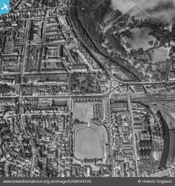
EAW044240 ENGLAND (1952). Lord's Cricket Ground and the surrounding area, St John's Wood, 1952
© Copyright OpenStreetMap contributors and licensed by the OpenStreetMap Foundation. 2026. Cartography is licensed as CC BY-SA.
Nearby Images (33)
Details
| Title | [EAW044240] Lord's Cricket Ground and the surrounding area, St John's Wood, 1952 |
| Reference | EAW044240 |
| Date | 23-June-1952 |
| Link | |
| Place name | ST JOHN'S WOOD |
| Parish | |
| District | |
| Country | ENGLAND |
| Easting / Northing | 527078, 182923 |
| Longitude / Latitude | -0.16777508452799, 51.530416305452 |
| National Grid Reference | TQ271829 |
Pins
Be the first to add a comment to this image!


![[EAW044240] Lord's Cricket Ground and the surrounding area, St John's Wood, 1952](http://britainfromabove.org.uk/sites/all/libraries/aerofilms-images/public/100x100/EAW/044/EAW044240.jpg)
![[EPW005641] St John's Chapel Grave Yard and Lord's Cricket Ground, St John's Wood, 1921](http://britainfromabove.org.uk/sites/all/libraries/aerofilms-images/public/100x100/EPW/005/EPW005641.jpg)
![[EAW018354] Wellington Road and environs, St John's Wood, from the east, 1948. This image has been produced from a print.](http://britainfromabove.org.uk/sites/all/libraries/aerofilms-images/public/100x100/EAW/018/EAW018354.jpg)
![[EAW018353] Lord's Cricket Ground, Wellington Road and environs, St John's Wood, from the south-east, 1948. This image has been produced from a print.](http://britainfromabove.org.uk/sites/all/libraries/aerofilms-images/public/100x100/EAW/018/EAW018353.jpg)
![[EPW027019] North Gate, St John the Baptist's Church and environs, St John's Wood, 1929](http://britainfromabove.org.uk/sites/all/libraries/aerofilms-images/public/100x100/EPW/027/EPW027019.jpg)
![[EPW027020] North Gate, St John the Baptist's Church and environs, St John's Wood, 1929](http://britainfromabove.org.uk/sites/all/libraries/aerofilms-images/public/100x100/EPW/027/EPW027020.jpg)
![[EPW027022] North Gate, Lord's Cricket Ground and Regent's Park, St John's Wood, 1929](http://britainfromabove.org.uk/sites/all/libraries/aerofilms-images/public/100x100/EPW/027/EPW027022.jpg)
![[EPW027018] North Gate, Lord's Cricket Ground and Regent's Park, St John's Wood, 1929](http://britainfromabove.org.uk/sites/all/libraries/aerofilms-images/public/100x100/EPW/027/EPW027018.jpg)
![[EPW027024] North Gate, Regent's Park and environs, St John's Wood, 1929](http://britainfromabove.org.uk/sites/all/libraries/aerofilms-images/public/100x100/EPW/027/EPW027024.jpg)
![[EPW027023] North Gate, Lord's Cricket Ground and Regent's Park, St John's Wood, 1929](http://britainfromabove.org.uk/sites/all/libraries/aerofilms-images/public/100x100/EPW/027/EPW027023.jpg)
![[EAW024223] Lord's Cricket Ground, Day Two of the Second Test of the New Zealand Tour of England, 1949](http://britainfromabove.org.uk/sites/all/libraries/aerofilms-images/public/100x100/EAW/024/EAW024223.jpg)
![[EPW021969] Lord's Cricket Ground and surroundings, St John's Wood, 1928](http://britainfromabove.org.uk/sites/all/libraries/aerofilms-images/public/100x100/EPW/021/EPW021969.jpg)
![[EPW027021] North Gate, Lord's Cricket Ground and Regent's Park, St John's Wood, 1929](http://britainfromabove.org.uk/sites/all/libraries/aerofilms-images/public/100x100/EPW/027/EPW027021.jpg)
![[EAW018355] North Gate, Wellington Road and environs, St John's Wood, from the south-east, 1948. This image has been produced from a print.](http://britainfromabove.org.uk/sites/all/libraries/aerofilms-images/public/100x100/EAW/018/EAW018355.jpg)
![[EAW030526] St John's Wood, a test match (England vs West Indies) underway at Lord's Cricket Ground, 1950](http://britainfromabove.org.uk/sites/all/libraries/aerofilms-images/public/100x100/EAW/030/EAW030526.jpg)
![[EAW030527] St John's Wood, a test match (England vs West Indies) underway at Lord's Cricket Ground, 1950](http://britainfromabove.org.uk/sites/all/libraries/aerofilms-images/public/100x100/EAW/030/EAW030527.jpg)
![[EPW039574] Lord's Cricket Ground and environs, St John's Wood, 1932](http://britainfromabove.org.uk/sites/all/libraries/aerofilms-images/public/100x100/EPW/039/EPW039574.jpg)
![[EPW027026] North Gate, Lord's Cricket Ground and Regent's Park, St John's Wood, 1929](http://britainfromabove.org.uk/sites/all/libraries/aerofilms-images/public/100x100/EPW/027/EPW027026.jpg)
![[EAW044241] Lord's Cricket Ground and the surrounding area, St John's Wood, 1952](http://britainfromabove.org.uk/sites/all/libraries/aerofilms-images/public/100x100/EAW/044/EAW044241.jpg)
![[EAW006466] Lord's Cricket Ground, St John's Wood, 1947](http://britainfromabove.org.uk/sites/all/libraries/aerofilms-images/public/100x100/EAW/006/EAW006466.jpg)
![[EAW044242] Lord's Cricket Ground, Regent's Park Boating Lake and the surrounding area, St John's Wood, 1952](http://britainfromabove.org.uk/sites/all/libraries/aerofilms-images/public/100x100/EAW/044/EAW044242.jpg)
![[EAW015849] Lord's Cricket Ground, St John's Wood, 1948. This image has been produced from a print.](http://britainfromabove.org.uk/sites/all/libraries/aerofilms-images/public/100x100/EAW/015/EAW015849.jpg)
![[EAW030528] St John's Wood, a test match (England vs West Indies) underway at Lord's Cricket Ground, 1950](http://britainfromabove.org.uk/sites/all/libraries/aerofilms-images/public/100x100/EAW/030/EAW030528.jpg)
![[EPW006155] Lord's Cricket Ground, St John's Wood, 1921](http://britainfromabove.org.uk/sites/all/libraries/aerofilms-images/public/100x100/EPW/006/EPW006155.jpg)
![[EAW015848] Lord's Cricket Ground, St John's Wood, 1948. This image has been produced from a print.](http://britainfromabove.org.uk/sites/all/libraries/aerofilms-images/public/100x100/EAW/015/EAW015848.jpg)
![[EPW031880] Regents Parks and environs, Regent's Park, 1930](http://britainfromabove.org.uk/sites/all/libraries/aerofilms-images/public/100x100/EPW/031/EPW031880.jpg)
![[EPW006681] St John's Wood, probably 2nd Ashes Test at Lords, 1921](http://britainfromabove.org.uk/sites/all/libraries/aerofilms-images/public/100x100/EPW/006/EPW006681.jpg)
![[EPW006684] St John's Wood, probably 2nd Ashes Test at Lords, 1921](http://britainfromabove.org.uk/sites/all/libraries/aerofilms-images/public/100x100/EPW/006/EPW006684.jpg)
![[EPW006688] St John's Wood, probably 2nd Ashes Test at Lords, 1921](http://britainfromabove.org.uk/sites/all/libraries/aerofilms-images/public/100x100/EPW/006/EPW006688.jpg)
![[EAW006465] Lord's Cricket Ground, St John's Wood, 1947](http://britainfromabove.org.uk/sites/all/libraries/aerofilms-images/public/100x100/EAW/006/EAW006465.jpg)
![[EPW006686] St John's Wood, probably 2nd Ashes Test at Lords, 1921](http://britainfromabove.org.uk/sites/all/libraries/aerofilms-images/public/100x100/EPW/006/EPW006686.jpg)
![[EPW006682] St John's Wood, probably 2nd Ashes Test at Lords, 1921](http://britainfromabove.org.uk/sites/all/libraries/aerofilms-images/public/100x100/EPW/006/EPW006682.jpg)
![[EPW006685] St John's Wood, probably 2nd Ashes Test at Lords, 1921](http://britainfromabove.org.uk/sites/all/libraries/aerofilms-images/public/100x100/EPW/006/EPW006685.jpg)