
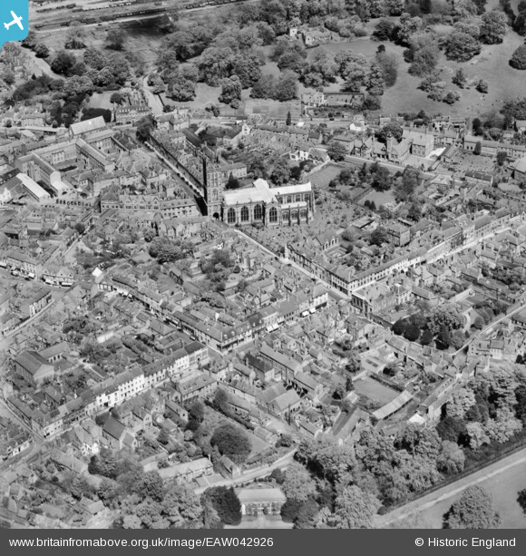
EAW042926 ENGLAND (1952). The Collegiate Church of St Mary and the town centre, Warwick, 1952
© Copyright OpenStreetMap contributors and licensed by the OpenStreetMap Foundation. 2026. Cartography is licensed as CC BY-SA.
Nearby Images (40)
EAW042926

EPW000412

EAW042928

EPW001213

EPW000410

EAW003264

EAW024695

EPW035695

EPW053229

EPW053227

EPW053228

EAW003655

EAW024692

EAW024691

EAW042927

EAW042934

EAW003265

EAW024696

EPW019742

EPW019741

EPW001203

EPW000406

EPW001204

EAW007533

EAW007535

EAW042933

EAW042929

EAW007538

EAW042931

EAW007536

EPW053230

EPW006600

EPR000079

EAW007534

EAW042930

EAW007539

EAW007531

EAW042935

EPW001192

EPR000080

Details
| Title | [EAW042926] The Collegiate Church of St Mary and the town centre, Warwick, 1952 |
| Reference | EAW042926 |
| Date | 5-July-1952 |
| Link | |
| Place name | WARWICK |
| Parish | WARWICK |
| District | |
| Country | ENGLAND |
| Easting / Northing | 428192, 264903 |
| Longitude / Latitude | -1.5867058915642, 52.281154550926 |
| National Grid Reference | SP282649 |
Pins

morbidthepoet |
Saturday 29th of June 2024 03:38:56 PM | |
|
morbidthepoet |
Saturday 29th of June 2024 03:38:37 PM | |
|
morbidthepoet |
Saturday 29th of June 2024 03:36:12 PM | |
|
morbidthepoet |
Saturday 29th of June 2024 03:35:52 PM | |
|
morbidthepoet |
Saturday 29th of June 2024 03:35:28 PM | |
|
morbidthepoet |
Saturday 29th of June 2024 03:33:46 PM | |
|
morbidthepoet |
Saturday 29th of June 2024 03:33:26 PM |