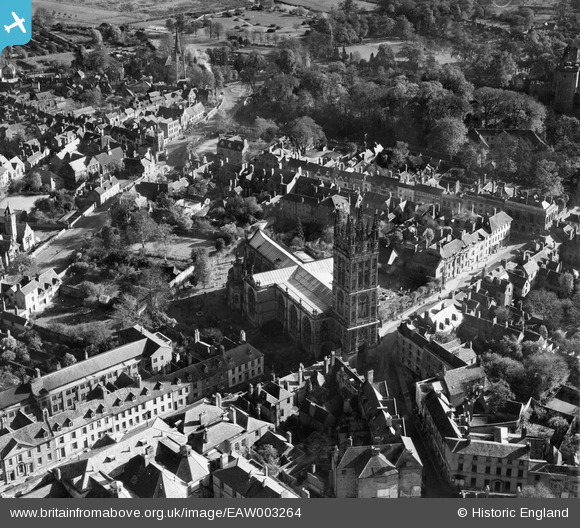
EAW003264 ENGLAND (1946). The Collegiate Church of St Mary, Warwick, 1946
© Copyright OpenStreetMap contributors and licensed by the OpenStreetMap Foundation. 2026. Cartography is licensed as CC BY-SA.
Nearby Images (23)
Details
| Title | [EAW003264] The Collegiate Church of St Mary, Warwick, 1946 |
| Reference | EAW003264 |
| Date | 4-November-1946 |
| Link | |
| Place name | WARWICK |
| Parish | WARWICK |
| District | |
| Country | ENGLAND |
| Easting / Northing | 428226, 264972 |
| Longitude / Latitude | -1.5862016876338, 52.281773189785 |
| National Grid Reference | SP282650 |
Pins
Be the first to add a comment to this image!


![[EAW003264] The Collegiate Church of St Mary, Warwick, 1946](http://britainfromabove.org.uk/sites/all/libraries/aerofilms-images/public/100x100/EAW/003/EAW003264.jpg)
![[EAW042928] The Collegiate Church of St Mary, Jury Street and the town centre, Warwick, 1952](http://britainfromabove.org.uk/sites/all/libraries/aerofilms-images/public/100x100/EAW/042/EAW042928.jpg)
![[EPW000412] St Mary's Church, Warwick, 1920](http://britainfromabove.org.uk/sites/all/libraries/aerofilms-images/public/100x100/EPW/000/EPW000412.jpg)
![[EAW024695] St Mary's Church and the town centre, Warwick, 1949](http://britainfromabove.org.uk/sites/all/libraries/aerofilms-images/public/100x100/EAW/024/EAW024695.jpg)
![[EPW035695] St Mary's Church, Warwick, 1931](http://britainfromabove.org.uk/sites/all/libraries/aerofilms-images/public/100x100/EPW/035/EPW035695.jpg)
![[EPW053227] The town centre, Warwick, 1937](http://britainfromabove.org.uk/sites/all/libraries/aerofilms-images/public/100x100/EPW/053/EPW053227.jpg)
![[EPW001213] St Mary's Church and Warwick Castle, Warwick, 1920](http://britainfromabove.org.uk/sites/all/libraries/aerofilms-images/public/100x100/EPW/001/EPW001213.jpg)
![[EAW042926] The Collegiate Church of St Mary and the town centre, Warwick, 1952](http://britainfromabove.org.uk/sites/all/libraries/aerofilms-images/public/100x100/EAW/042/EAW042926.jpg)
![[EAW024692] St Mary's Church, Warwick Castle and the town centre, Warwick, from the north, 1949](http://britainfromabove.org.uk/sites/all/libraries/aerofilms-images/public/100x100/EAW/024/EAW024692.jpg)
![[EPW000410] Warwick, from the south-west, 1920](http://britainfromabove.org.uk/sites/all/libraries/aerofilms-images/public/100x100/EPW/000/EPW000410.jpg)
![[EAW042927] The Collegiate Church of St Mary and the town centre, Warwick, 1952](http://britainfromabove.org.uk/sites/all/libraries/aerofilms-images/public/100x100/EAW/042/EAW042927.jpg)
![[EPW053228] Warwick Castle and the town centre, Warwick, 1937](http://britainfromabove.org.uk/sites/all/libraries/aerofilms-images/public/100x100/EPW/053/EPW053228.jpg)
![[EPW053229] The town centre, Warwick, 1937](http://britainfromabove.org.uk/sites/all/libraries/aerofilms-images/public/100x100/EPW/053/EPW053229.jpg)
![[EAW024691] St Mary's Church, Warwick Castle and the town centre, Warwick, from the north-west, 1949](http://britainfromabove.org.uk/sites/all/libraries/aerofilms-images/public/100x100/EAW/024/EAW024691.jpg)
![[EAW003655] Warwick Castle and the town, Warwick, 1947](http://britainfromabove.org.uk/sites/all/libraries/aerofilms-images/public/100x100/EAW/003/EAW003655.jpg)
![[EAW042934] Warwick Castle, Castle Lane and Jury Street, Warwick, 1952](http://britainfromabove.org.uk/sites/all/libraries/aerofilms-images/public/100x100/EAW/042/EAW042934.jpg)
![[EAW003265] The town centre, Warwick, from the west, 1946](http://britainfromabove.org.uk/sites/all/libraries/aerofilms-images/public/100x100/EAW/003/EAW003265.jpg)
![[EAW024696] Warwick Castle, Warwick, 1949](http://britainfromabove.org.uk/sites/all/libraries/aerofilms-images/public/100x100/EAW/024/EAW024696.jpg)
![[EPW001205] View of Warwick and Warwick Castle, Warwick, 1920](http://britainfromabove.org.uk/sites/all/libraries/aerofilms-images/public/100x100/EPW/001/EPW001205.jpg)
![[EPW000406] Warwick Castle, Warwick, 1920](http://britainfromabove.org.uk/sites/all/libraries/aerofilms-images/public/100x100/EPW/000/EPW000406.jpg)
![[EAW007533] Warwick Castle, Warwick, 1947. This image has been produced from a print.](http://britainfromabove.org.uk/sites/all/libraries/aerofilms-images/public/100x100/EAW/007/EAW007533.jpg)
![[EAW042929] Warwick Castle, Warwick, 1952](http://britainfromabove.org.uk/sites/all/libraries/aerofilms-images/public/100x100/EAW/042/EAW042929.jpg)
![[EPW019741] The High Street and the town centre, Warwick, 1927](http://britainfromabove.org.uk/sites/all/libraries/aerofilms-images/public/100x100/EPW/019/EPW019741.jpg)