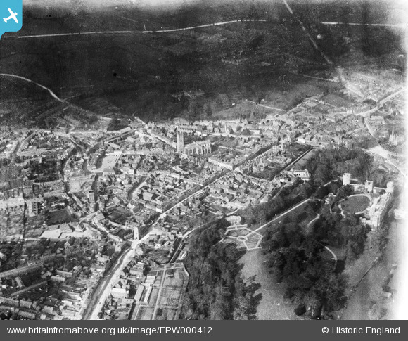
EPW000412 ENGLAND (1920). St Mary's Church, Warwick, 1920
© Copyright OpenStreetMap contributors and licensed by the OpenStreetMap Foundation. 2026. Cartography is licensed as CC BY-SA.
Nearby Images (33)
Details
| Title | [EPW000412] St Mary's Church, Warwick, 1920 |
| Reference | EPW000412 |
| Date | April-1920 |
| Link | |
| Place name | WARWICK |
| Parish | WARWICK |
| District | |
| Country | ENGLAND |
| Easting / Northing | 428198, 264934 |
| Longitude / Latitude | -1.5866153405253, 52.281432966442 |
| National Grid Reference | SP282649 |
Pins
Be the first to add a comment to this image!


![[EPW000412] St Mary's Church, Warwick, 1920](http://britainfromabove.org.uk/sites/all/libraries/aerofilms-images/public/100x100/EPW/000/EPW000412.jpg)
![[EAW042928] The Collegiate Church of St Mary, Jury Street and the town centre, Warwick, 1952](http://britainfromabove.org.uk/sites/all/libraries/aerofilms-images/public/100x100/EAW/042/EAW042928.jpg)
![[EAW042926] The Collegiate Church of St Mary and the town centre, Warwick, 1952](http://britainfromabove.org.uk/sites/all/libraries/aerofilms-images/public/100x100/EAW/042/EAW042926.jpg)
![[EAW003264] The Collegiate Church of St Mary, Warwick, 1946](http://britainfromabove.org.uk/sites/all/libraries/aerofilms-images/public/100x100/EAW/003/EAW003264.jpg)
![[EAW024695] St Mary's Church and the town centre, Warwick, 1949](http://britainfromabove.org.uk/sites/all/libraries/aerofilms-images/public/100x100/EAW/024/EAW024695.jpg)
![[EPW035695] St Mary's Church, Warwick, 1931](http://britainfromabove.org.uk/sites/all/libraries/aerofilms-images/public/100x100/EPW/035/EPW035695.jpg)
![[EPW001213] St Mary's Church and Warwick Castle, Warwick, 1920](http://britainfromabove.org.uk/sites/all/libraries/aerofilms-images/public/100x100/EPW/001/EPW001213.jpg)
![[EPW000410] Warwick, from the south-west, 1920](http://britainfromabove.org.uk/sites/all/libraries/aerofilms-images/public/100x100/EPW/000/EPW000410.jpg)
![[EPW053227] The town centre, Warwick, 1937](http://britainfromabove.org.uk/sites/all/libraries/aerofilms-images/public/100x100/EPW/053/EPW053227.jpg)
![[EPW053229] The town centre, Warwick, 1937](http://britainfromabove.org.uk/sites/all/libraries/aerofilms-images/public/100x100/EPW/053/EPW053229.jpg)
![[EAW024692] St Mary's Church, Warwick Castle and the town centre, Warwick, from the north, 1949](http://britainfromabove.org.uk/sites/all/libraries/aerofilms-images/public/100x100/EAW/024/EAW024692.jpg)
![[EPW053228] Warwick Castle and the town centre, Warwick, 1937](http://britainfromabove.org.uk/sites/all/libraries/aerofilms-images/public/100x100/EPW/053/EPW053228.jpg)
![[EAW042927] The Collegiate Church of St Mary and the town centre, Warwick, 1952](http://britainfromabove.org.uk/sites/all/libraries/aerofilms-images/public/100x100/EAW/042/EAW042927.jpg)
![[EAW003655] Warwick Castle and the town, Warwick, 1947](http://britainfromabove.org.uk/sites/all/libraries/aerofilms-images/public/100x100/EAW/003/EAW003655.jpg)
![[EAW024691] St Mary's Church, Warwick Castle and the town centre, Warwick, from the north-west, 1949](http://britainfromabove.org.uk/sites/all/libraries/aerofilms-images/public/100x100/EAW/024/EAW024691.jpg)
![[EAW003265] The town centre, Warwick, from the west, 1946](http://britainfromabove.org.uk/sites/all/libraries/aerofilms-images/public/100x100/EAW/003/EAW003265.jpg)
![[EAW042934] Warwick Castle, Castle Lane and Jury Street, Warwick, 1952](http://britainfromabove.org.uk/sites/all/libraries/aerofilms-images/public/100x100/EAW/042/EAW042934.jpg)
![[EAW024696] Warwick Castle, Warwick, 1949](http://britainfromabove.org.uk/sites/all/libraries/aerofilms-images/public/100x100/EAW/024/EAW024696.jpg)
![[EPW019742] The Market Place and the town centre, Warwick, 1927](http://britainfromabove.org.uk/sites/all/libraries/aerofilms-images/public/100x100/EPW/019/EPW019742.jpg)
![[EPW019741] The High Street and the town centre, Warwick, 1927](http://britainfromabove.org.uk/sites/all/libraries/aerofilms-images/public/100x100/EPW/019/EPW019741.jpg)
![[EPW000406] Warwick Castle, Warwick, 1920](http://britainfromabove.org.uk/sites/all/libraries/aerofilms-images/public/100x100/EPW/000/EPW000406.jpg)
![[EPW001203] Warwick Castle, Warwick, 1920](http://britainfromabove.org.uk/sites/all/libraries/aerofilms-images/public/100x100/EPW/001/EPW001203.jpg)
![[EPW001204] Warwick Castle, Warwick, 1920](http://britainfromabove.org.uk/sites/all/libraries/aerofilms-images/public/100x100/EPW/001/EPW001204.jpg)
![[EAW007533] Warwick Castle, Warwick, 1947. This image has been produced from a print.](http://britainfromabove.org.uk/sites/all/libraries/aerofilms-images/public/100x100/EAW/007/EAW007533.jpg)
![[EAW042929] Warwick Castle, Warwick, 1952](http://britainfromabove.org.uk/sites/all/libraries/aerofilms-images/public/100x100/EAW/042/EAW042929.jpg)
![[EAW007535] Warwick Castle, Warwick, 1947. This image has been produced from a print.](http://britainfromabove.org.uk/sites/all/libraries/aerofilms-images/public/100x100/EAW/007/EAW007535.jpg)
![[EAW042933] Warwick Castle, Warwick, 1952](http://britainfromabove.org.uk/sites/all/libraries/aerofilms-images/public/100x100/EAW/042/EAW042933.jpg)
![[EAW007536] Warwick Castle, Warwick, 1947](http://britainfromabove.org.uk/sites/all/libraries/aerofilms-images/public/100x100/EAW/007/EAW007536.jpg)
![[EPW053230] Warwick Castle, Warwick, 1937. This image has been produced from a copy-negative.](http://britainfromabove.org.uk/sites/all/libraries/aerofilms-images/public/100x100/EPW/053/EPW053230.jpg)
![[EPW006600] Warwick Castle and Mill, Warwick 1921](http://britainfromabove.org.uk/sites/all/libraries/aerofilms-images/public/100x100/EPW/006/EPW006600.jpg)
![[EPR000079] Warwick Castle, Warwick, 1934](http://britainfromabove.org.uk/sites/all/libraries/aerofilms-images/public/100x100/EPR/000/EPR000079.jpg)
![[EAW007531] Warwick Castle, Warwick, 1947](http://britainfromabove.org.uk/sites/all/libraries/aerofilms-images/public/100x100/EAW/007/EAW007531.jpg)
![[EAW042935] Warwick Castle, Warwick, 1952](http://britainfromabove.org.uk/sites/all/libraries/aerofilms-images/public/100x100/EAW/042/EAW042935.jpg)