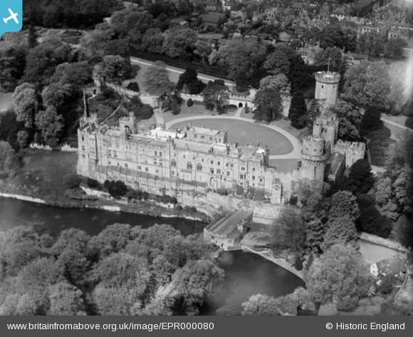
EPR000080 ENGLAND (1934). Warwick Castle, Warwick, 1934
© Copyright OpenStreetMap contributors and licensed by the OpenStreetMap Foundation. 2026. Cartography is licensed as CC BY-SA.
Nearby Images (44)
Details
| Title | [EPR000080] Warwick Castle, Warwick, 1934 |
| Reference | EPR000080 |
| Date | May-1934 |
| Link | |
| Place name | WARWICK |
| Parish | WARWICK |
| District | |
| Country | ENGLAND |
| Easting / Northing | 428438, 264661 |
| Longitude / Latitude | -1.5831200580415, 52.278966035301 |
| National Grid Reference | SP284647 |
Pins
Be the first to add a comment to this image!


![[EPR000080] Warwick Castle, Warwick, 1934](http://britainfromabove.org.uk/sites/all/libraries/aerofilms-images/public/100x100/EPR/000/EPR000080.jpg)
![[EPW001192] Warwick Castle and town, Warwick, 1920](http://britainfromabove.org.uk/sites/all/libraries/aerofilms-images/public/100x100/EPW/001/EPW001192.jpg)
![[EAW007532] Warwick Castle, Warwick, 1947](http://britainfromabove.org.uk/sites/all/libraries/aerofilms-images/public/100x100/EAW/007/EAW007532.jpg)
![[EPW035697] Warwick Castle, Warwick, 1931](http://britainfromabove.org.uk/sites/all/libraries/aerofilms-images/public/100x100/EPW/035/EPW035697.jpg)
![[EAW003267] Warwick Castle and the town, Warwick, from the south-east, 1946](http://britainfromabove.org.uk/sites/all/libraries/aerofilms-images/public/100x100/EAW/003/EAW003267.jpg)
![[EAW024698] Warwick Castle, St Mary's Church and the town centre, Warwick, from the east, 1949](http://britainfromabove.org.uk/sites/all/libraries/aerofilms-images/public/100x100/EAW/024/EAW024698.jpg)
![[EAW007531] Warwick Castle, Warwick, 1947](http://britainfromabove.org.uk/sites/all/libraries/aerofilms-images/public/100x100/EAW/007/EAW007531.jpg)
![[EAW042935] Warwick Castle, Warwick, 1952](http://britainfromabove.org.uk/sites/all/libraries/aerofilms-images/public/100x100/EAW/042/EAW042935.jpg)
![[EAW003266] Warwick Castle and the town, Warwick, from the south-east, 1946](http://britainfromabove.org.uk/sites/all/libraries/aerofilms-images/public/100x100/EAW/003/EAW003266.jpg)
![[EAW007539] Warwick Castle, Warwick, 1947](http://britainfromabove.org.uk/sites/all/libraries/aerofilms-images/public/100x100/EAW/007/EAW007539.jpg)
![[EPW006602] Warwick Castle and Mill, Warwick 1921](http://britainfromabove.org.uk/sites/all/libraries/aerofilms-images/public/100x100/EPW/006/EPW006602.jpg)
![[EPW019739] Warwick Castle and the Collegiate Church of St Mary, Warwick, 1927](http://britainfromabove.org.uk/sites/all/libraries/aerofilms-images/public/100x100/EPW/019/EPW019739.jpg)
![[EAW024697] Warwick Castle, St Mary's Church and the town centre, Warwick, from the south-east, 1949](http://britainfromabove.org.uk/sites/all/libraries/aerofilms-images/public/100x100/EAW/024/EAW024697.jpg)
![[EAW042930] Warwick Castle, Warwick, 1952](http://britainfromabove.org.uk/sites/all/libraries/aerofilms-images/public/100x100/EAW/042/EAW042930.jpg)
![[EAW007534] Warwick Castle, Warwick, 1947. This image has been produced from a print.](http://britainfromabove.org.uk/sites/all/libraries/aerofilms-images/public/100x100/EAW/007/EAW007534.jpg)
![[EPW006600] Warwick Castle and Mill, Warwick 1921](http://britainfromabove.org.uk/sites/all/libraries/aerofilms-images/public/100x100/EPW/006/EPW006600.jpg)
![[EPR000079] Warwick Castle, Warwick, 1934](http://britainfromabove.org.uk/sites/all/libraries/aerofilms-images/public/100x100/EPR/000/EPR000079.jpg)
![[EAW007536] Warwick Castle, Warwick, 1947](http://britainfromabove.org.uk/sites/all/libraries/aerofilms-images/public/100x100/EAW/007/EAW007536.jpg)
![[EAW007537] Warwick Castle, Warwick, 1947. This image has been produced from a print.](http://britainfromabove.org.uk/sites/all/libraries/aerofilms-images/public/100x100/EAW/007/EAW007537.jpg)
![[EPW053230] Warwick Castle, Warwick, 1937. This image has been produced from a copy-negative.](http://britainfromabove.org.uk/sites/all/libraries/aerofilms-images/public/100x100/EPW/053/EPW053230.jpg)
![[EAW003654] Warwick Castle and the town, Warwick, 1947](http://britainfromabove.org.uk/sites/all/libraries/aerofilms-images/public/100x100/EAW/003/EAW003654.jpg)
![[EAW007535] Warwick Castle, Warwick, 1947. This image has been produced from a print.](http://britainfromabove.org.uk/sites/all/libraries/aerofilms-images/public/100x100/EAW/007/EAW007535.jpg)
![[EAW042933] Warwick Castle, Warwick, 1952](http://britainfromabove.org.uk/sites/all/libraries/aerofilms-images/public/100x100/EAW/042/EAW042933.jpg)
![[EAW007538] Warwick Castle, Warwick, 1947](http://britainfromabove.org.uk/sites/all/libraries/aerofilms-images/public/100x100/EAW/007/EAW007538.jpg)
![[EAW042929] Warwick Castle, Warwick, 1952](http://britainfromabove.org.uk/sites/all/libraries/aerofilms-images/public/100x100/EAW/042/EAW042929.jpg)
![[EPW035696] Warwick Castle, Warwick, 1931](http://britainfromabove.org.uk/sites/all/libraries/aerofilms-images/public/100x100/EPW/035/EPW035696.jpg)
![[EPW019740] Warwick Castle and the River Avon, Warwick, 1927](http://britainfromabove.org.uk/sites/all/libraries/aerofilms-images/public/100x100/EPW/019/EPW019740.jpg)
![[EPW001208] Warwick Castle, Warwick, 1920](http://britainfromabove.org.uk/sites/all/libraries/aerofilms-images/public/100x100/EPW/001/EPW001208.jpg)
![[EAW042931] Warwick Castle, Warwick, 1952](http://britainfromabove.org.uk/sites/all/libraries/aerofilms-images/public/100x100/EAW/042/EAW042931.jpg)
![[EAW007533] Warwick Castle, Warwick, 1947. This image has been produced from a print.](http://britainfromabove.org.uk/sites/all/libraries/aerofilms-images/public/100x100/EAW/007/EAW007533.jpg)
![[EPW001203] Warwick Castle, Warwick, 1920](http://britainfromabove.org.uk/sites/all/libraries/aerofilms-images/public/100x100/EPW/001/EPW001203.jpg)
![[EPW001204] Warwick Castle, Warwick, 1920](http://britainfromabove.org.uk/sites/all/libraries/aerofilms-images/public/100x100/EPW/001/EPW001204.jpg)
![[EPW000406] Warwick Castle, Warwick, 1920](http://britainfromabove.org.uk/sites/all/libraries/aerofilms-images/public/100x100/EPW/000/EPW000406.jpg)
![[EAW042932] Warwick Castle, Warwick, 1952](http://britainfromabove.org.uk/sites/all/libraries/aerofilms-images/public/100x100/EAW/042/EAW042932.jpg)
![[EAW024694] Warwick Castle, Lammas Field and the town, Warwick, from the east, 1949](http://britainfromabove.org.uk/sites/all/libraries/aerofilms-images/public/100x100/EAW/024/EAW024694.jpg)
![[EPW001207] Warwick Castle, Warwick, 1920](http://britainfromabove.org.uk/sites/all/libraries/aerofilms-images/public/100x100/EPW/001/EPW001207.jpg)
![[EAW024696] Warwick Castle, Warwick, 1949](http://britainfromabove.org.uk/sites/all/libraries/aerofilms-images/public/100x100/EAW/024/EAW024696.jpg)
![[EAW042934] Warwick Castle, Castle Lane and Jury Street, Warwick, 1952](http://britainfromabove.org.uk/sites/all/libraries/aerofilms-images/public/100x100/EAW/042/EAW042934.jpg)
![[EAW024693] Warwick Castle, Lammas Field and the town, Warwick, from the east, 1949](http://britainfromabove.org.uk/sites/all/libraries/aerofilms-images/public/100x100/EAW/024/EAW024693.jpg)
![[EPW000405] Warwick Castle, Warwick, from the south-east, 1920](http://britainfromabove.org.uk/sites/all/libraries/aerofilms-images/public/100x100/EPW/000/EPW000405.jpg)
![[EPW053228] Warwick Castle and the town centre, Warwick, 1937](http://britainfromabove.org.uk/sites/all/libraries/aerofilms-images/public/100x100/EPW/053/EPW053228.jpg)
![[EAW003655] Warwick Castle and the town, Warwick, 1947](http://britainfromabove.org.uk/sites/all/libraries/aerofilms-images/public/100x100/EAW/003/EAW003655.jpg)
![[EPW001213] St Mary's Church and Warwick Castle, Warwick, 1920](http://britainfromabove.org.uk/sites/all/libraries/aerofilms-images/public/100x100/EPW/001/EPW001213.jpg)
![[EAW042926] The Collegiate Church of St Mary and the town centre, Warwick, 1952](http://britainfromabove.org.uk/sites/all/libraries/aerofilms-images/public/100x100/EAW/042/EAW042926.jpg)