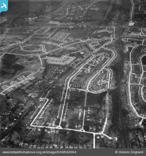
EAW042064 ENGLAND (1952). Housing estates at Poverest, Orpington, 1952
© Copyright OpenStreetMap contributors and licensed by the OpenStreetMap Foundation. 2026. Cartography is licensed as CC BY-SA.
Nearby Images (12)
Details
| Title | [EAW042064] Housing estates at Poverest, Orpington, 1952 |
| Reference | EAW042064 |
| Date | March-1952 |
| Link | |
| Place name | ORPINGTON |
| Parish | |
| District | |
| Country | ENGLAND |
| Easting / Northing | 546035, 168636 |
| Longitude / Latitude | 0.099461543964491, 51.397440914876 |
| National Grid Reference | TQ460686 |
Pins

garyb |
Friday 1st of August 2014 04:10:44 PM | |

garyb |
Friday 1st of August 2014 04:09:38 PM | |

garyb |
Friday 1st of August 2014 04:08:37 PM | |

garyb |
Friday 1st of August 2014 04:01:22 PM | |

garyb |
Friday 1st of August 2014 03:56:53 PM | |

garyb |
Friday 1st of August 2014 03:42:38 PM | |

garyb |
Friday 1st of August 2014 03:40:41 PM | |

garyb |
Friday 1st of August 2014 03:39:05 PM | |

garyb |
Sunday 1st of June 2014 04:01:36 PM | |

garyb |
Sunday 1st of June 2014 03:57:42 PM | |

garyb |
Sunday 1st of June 2014 03:52:41 PM | |

garyb |
Sunday 1st of June 2014 02:37:47 PM | |

Gone2Kent |
Friday 30th of May 2014 01:36:19 PM | |

Gone2Kent |
Friday 30th of May 2014 01:36:16 PM | |

garyb |
Friday 30th of May 2014 12:06:18 AM | |

garyb |
Thursday 29th of May 2014 11:41:24 PM | |

garyb |
Thursday 29th of May 2014 10:16:28 PM | |

garyb |
Thursday 29th of May 2014 10:06:54 PM | |

garyb |
Thursday 29th of May 2014 09:49:05 PM |
User Comment Contributions
This image actually only shows a very small portion of the Poverest estate. The majority of the area captured in this frame is of St Pauls Cray. |

garyb |
Friday 30th of May 2014 12:31:35 AM |


![[EAW042064] Housing estates at Poverest, Orpington, 1952](http://britainfromabove.org.uk/sites/all/libraries/aerofilms-images/public/100x100/EAW/042/EAW042064.jpg)
![[EAW020730] New housing development around Ravensbury Road, St Paul's Cray, 1948](http://britainfromabove.org.uk/sites/all/libraries/aerofilms-images/public/100x100/EAW/020/EAW020730.jpg)
![[EAW042062] Housing estates at Poverest, Orpington, 1952](http://britainfromabove.org.uk/sites/all/libraries/aerofilms-images/public/100x100/EAW/042/EAW042062.jpg)
![[EAW021760] Housing estate under construction surrounding Clarendon Way and Ravensbury Road, St Paul's Cray, 1949](http://britainfromabove.org.uk/sites/all/libraries/aerofilms-images/public/100x100/EAW/021/EAW021760.jpg)
![[EAW042061] Housing estates at Poverest, Orpington, 1952](http://britainfromabove.org.uk/sites/all/libraries/aerofilms-images/public/100x100/EAW/042/EAW042061.jpg)
![[EAW026809] Housing estate under construction at St Paul's Cray, Bromley, 1949. This image was marked by Aerofilms Ltd for photo editing.](http://britainfromabove.org.uk/sites/all/libraries/aerofilms-images/public/100x100/EAW/026/EAW026809.jpg)
![[EAW020737] Construction of housing along Ravensbury Road, St Paul's Cray, from the south, 1948](http://britainfromabove.org.uk/sites/all/libraries/aerofilms-images/public/100x100/EAW/020/EAW020737.jpg)
![[EAW020739] Construction of 34-40 Ravensbury Road, St Paul's Cray, from the south, 1948](http://britainfromabove.org.uk/sites/all/libraries/aerofilms-images/public/100x100/EAW/020/EAW020739.jpg)
![[EAW020736] Wimborne Avenue and construction of 1 and 3 Ravensbury Road, St Paul's Cray, from the south, 1948](http://britainfromabove.org.uk/sites/all/libraries/aerofilms-images/public/100x100/EAW/020/EAW020736.jpg)
![[EAW020733] New housing development around Ravensbury Road, St Paul's Cray, 1948](http://britainfromabove.org.uk/sites/all/libraries/aerofilms-images/public/100x100/EAW/020/EAW020733.jpg)
![[EAW026815] Housing estate under construction at St Paul's Cray, Bromley, 1949. This image has been produced from a print.](http://britainfromabove.org.uk/sites/all/libraries/aerofilms-images/public/100x100/EAW/026/EAW026815.jpg)
![[EAW020738] Construction of 50 and 52, 75 and 77 Ravensbury Road, St Paul's Cray, 1948](http://britainfromabove.org.uk/sites/all/libraries/aerofilms-images/public/100x100/EAW/020/EAW020738.jpg)