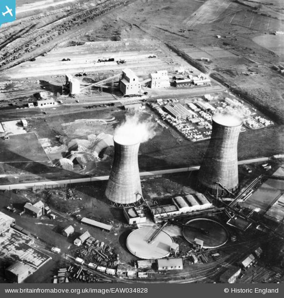
EAW034828 ENGLAND (1951). Part of the John Lysaght Normanby Park Steel Works, Scunthorpe, 1951. This image has been produced from a print.
© Copyright OpenStreetMap contributors and licensed by the OpenStreetMap Foundation. 2026. Cartography is licensed as CC BY-SA.
Nearby Images (48)
Details
| Title | [EAW034828] Part of the John Lysaght Normanby Park Steel Works, Scunthorpe, 1951. This image has been produced from a print. |
| Reference | EAW034828 |
| Date | 1-March-1951 |
| Link | |
| Place name | SCUNTHORPE |
| Parish | |
| District | |
| Country | ENGLAND |
| Easting / Northing | 488941, 414178 |
| Longitude / Latitude | -0.65531433458892, 53.616349585838 |
| National Grid Reference | SE889142 |
Pins
Be the first to add a comment to this image!


![[EAW034828] Part of the John Lysaght Normanby Park Steel Works, Scunthorpe, 1951. This image has been produced from a print.](http://britainfromabove.org.uk/sites/all/libraries/aerofilms-images/public/100x100/EAW/034/EAW034828.jpg)
![[EAW034821] Part of the John Lysaght Normanby Park Steel Works, Scunthorpe, 1951. This image has been produced from a print.](http://britainfromabove.org.uk/sites/all/libraries/aerofilms-images/public/100x100/EAW/034/EAW034821.jpg)
![[EAW021138] Part of the John Lysaght Ltd Normanby Park Steel Works, Scunthorpe, 1949. This image has been produced from a print.](http://britainfromabove.org.uk/sites/all/libraries/aerofilms-images/public/100x100/EAW/021/EAW021138.jpg)
![[EAW031183] The John Lysaght Normanby Park Steel Works, Scunthorpe, 1950](http://britainfromabove.org.uk/sites/all/libraries/aerofilms-images/public/100x100/EAW/031/EAW031183.jpg)
![[EAW013488] The northern end of the John Lysaght Normanby Park Steel Works site, Scunthorpe, 1948. This image was marked by Aerofilms Ltd for photo editing.](http://britainfromabove.org.uk/sites/all/libraries/aerofilms-images/public/100x100/EAW/013/EAW013488.jpg)
![[EAW027178] The John Lysaght Normanby Park Steel Works, Scunthorpe, 1949](http://britainfromabove.org.uk/sites/all/libraries/aerofilms-images/public/100x100/EAW/027/EAW027178.jpg)
![[EAW021137] Part of the John Lysaght Ltd Normanby Park Steel Works, Scunthorpe, 1949. This image has been produced from a print.](http://britainfromabove.org.uk/sites/all/libraries/aerofilms-images/public/100x100/EAW/021/EAW021137.jpg)
![[EAW028570] Part of the John Lysaght Normanby Park Steel Works, Scunthorpe, 1950](http://britainfromabove.org.uk/sites/all/libraries/aerofilms-images/public/100x100/EAW/028/EAW028570.jpg)
![[EAW028571] Part of the John Lysaght Normanby Park Steel Works, Scunthorpe, 1950](http://britainfromabove.org.uk/sites/all/libraries/aerofilms-images/public/100x100/EAW/028/EAW028571.jpg)
![[EAW013834] The John Lysaght Ltd Normanby Park Steel Works, Scunthorpe, 1948](http://britainfromabove.org.uk/sites/all/libraries/aerofilms-images/public/100x100/EAW/013/EAW013834.jpg)
![[EAW013831] The John Lysaght Ltd Normanby Park Steel Works, Scunthorpe, 1948. This image was marked by Aerofilms Ltd for photo editing.](http://britainfromabove.org.uk/sites/all/libraries/aerofilms-images/public/100x100/EAW/013/EAW013831.jpg)
![[EAW013832] The John Lysaght Ltd Normanby Park Steel Works, Scunthorpe, 1948](http://britainfromabove.org.uk/sites/all/libraries/aerofilms-images/public/100x100/EAW/013/EAW013832.jpg)
![[EAW021132] Part of the John Lysaght Ltd Normanby Park Steel Works, Scunthorpe, 1949. This image has been produced from a print.](http://britainfromabove.org.uk/sites/all/libraries/aerofilms-images/public/100x100/EAW/021/EAW021132.jpg)
![[EAW031173] The John Lysaght Normanby Park Steel Works, Scunthorpe, 1950. This image was marked by Aerofilms Ltd for photo editing.](http://britainfromabove.org.uk/sites/all/libraries/aerofilms-images/public/100x100/EAW/031/EAW031173.jpg)
![[EAW013833] The John Lysaght Ltd Normanby Park Steel Works, Scunthorpe, 1948](http://britainfromabove.org.uk/sites/all/libraries/aerofilms-images/public/100x100/EAW/013/EAW013833.jpg)
![[EPW048948] The John Lysaght Normanby Park Steel Works, Scunthorpe, from the north-east, 1935. This image has been affected by flare.](http://britainfromabove.org.uk/sites/all/libraries/aerofilms-images/public/100x100/EPW/048/EPW048948.jpg)
![[EAW013490] The northern end of the John Lysaght Normanby Park Steel Works site, Scunthorpe, from the south-east, 1948. This image was marked by Aerofilms Ltd for photo editing.](http://britainfromabove.org.uk/sites/all/libraries/aerofilms-images/public/100x100/EAW/013/EAW013490.jpg)
![[EAW034829] Steam billowing from a shadowy Normanby Park Steel Works, Scunthorpe, from the north-east, 1951](http://britainfromabove.org.uk/sites/all/libraries/aerofilms-images/public/100x100/EAW/034/EAW034829.jpg)
![[EAW041828] The John Lysaght Normanby Park Steel Works, Scunthorpe, 1952. This image has been produced from a print.](http://britainfromabove.org.uk/sites/all/libraries/aerofilms-images/public/100x100/EAW/041/EAW041828.jpg)
![[EAW028583] Part of the John Lysaght Normanby Park Steel Works, Scunthorpe, 1950](http://britainfromabove.org.uk/sites/all/libraries/aerofilms-images/public/100x100/EAW/028/EAW028583.jpg)
![[EAW009626] The John Lysaght Normanby Park Steel Works, Scunthorpe, 1947](http://britainfromabove.org.uk/sites/all/libraries/aerofilms-images/public/100x100/EAW/009/EAW009626.jpg)
![[EAW016662] John Lysaght Ltd Normanby Park Steel Works and environs, Scunthorpe, 1948](http://britainfromabove.org.uk/sites/all/libraries/aerofilms-images/public/100x100/EAW/016/EAW016662.jpg)
![[EPW048950] The John Lysaght Normanby Park Steel Works, Scunthorpe, from the north-east, 1935. This image has been produced from a damaged negative.](http://britainfromabove.org.uk/sites/all/libraries/aerofilms-images/public/100x100/EPW/048/EPW048950.jpg)
![[EAW038771] Part of the John Lysaght Ltd Normanby Park Steel Works, Scunthorpe, 1951. This image has been produced from a print.](http://britainfromabove.org.uk/sites/all/libraries/aerofilms-images/public/100x100/EAW/038/EAW038771.jpg)
![[EAW009411] The John Lysaght Normanby Park Steel Works, Flixborough, from the south-east, 1947. This image has been produced from a print.](http://britainfromabove.org.uk/sites/all/libraries/aerofilms-images/public/100x100/EAW/009/EAW009411.jpg)
![[EAW028575] Part of the John Lysaght Normanby Park Steel Works, Scunthorpe, 1950](http://britainfromabove.org.uk/sites/all/libraries/aerofilms-images/public/100x100/EAW/028/EAW028575.jpg)
![[EAW019669] The John Lysaght Normanby Park Steel Works Opencast Ironstone Quarry, Scunthorpe, from the west, 1948. This image has been produced from a print.](http://britainfromabove.org.uk/sites/all/libraries/aerofilms-images/public/100x100/EAW/019/EAW019669.jpg)
![[EAW013489] The northern end of the John Lysaght Normanby Park Steel Works site, Scunthorpe, from the south-west, 1948. This image was marked by Aerofilms Ltd for photo editing.](http://britainfromabove.org.uk/sites/all/libraries/aerofilms-images/public/100x100/EAW/013/EAW013489.jpg)
![[EAW034811] Part of the John Lysaght Normanby Park Steel Works, Scunthorpe, 1951. This image has been produced from a print.](http://britainfromabove.org.uk/sites/all/libraries/aerofilms-images/public/100x100/EAW/034/EAW034811.jpg)
![[EAW016658] John Lysaght Ltd Normanby Park Steel Works, Scunthorpe, 1948](http://britainfromabove.org.uk/sites/all/libraries/aerofilms-images/public/100x100/EAW/016/EAW016658.jpg)
![[EAW009637] The John Lysaght Normanby Park Steel Works, Scunthorpe, 1947](http://britainfromabove.org.uk/sites/all/libraries/aerofilms-images/public/100x100/EAW/009/EAW009637.jpg)
![[EAW038776] Part of the John Lysaght Ltd Normanby Park Steel Works, Scunthorpe, 1951. This image has been produced from a print.](http://britainfromabove.org.uk/sites/all/libraries/aerofilms-images/public/100x100/EAW/038/EAW038776.jpg)
![[EAW049671] The John Lysaght Normanby Park Steel Works, Scunthorpe, 1953. This image was marked by Aerofilms Ltd for photo editing.](http://britainfromabove.org.uk/sites/all/libraries/aerofilms-images/public/100x100/EAW/049/EAW049671.jpg)
![[EAW041851] Part of the John Lysaght Normanby Park Steel Works, Scunthorpe, 1952. This image has been produced from a print marked by Aerofilms Ltd for photo editing.](http://britainfromabove.org.uk/sites/all/libraries/aerofilms-images/public/100x100/EAW/041/EAW041851.jpg)
![[EPW048523] The John Lysaght Normanby Park Steel Works, Scunthorpe, 1935](http://britainfromabove.org.uk/sites/all/libraries/aerofilms-images/public/100x100/EPW/048/EPW048523.jpg)
![[EAW038746] John Lysaght Ltd Normanby Park Steel Works, Scunthorpe, 1951. This image has been produced from a print marked by Aerofilms Ltd for photo editing.](http://britainfromabove.org.uk/sites/all/libraries/aerofilms-images/public/100x100/EAW/038/EAW038746.jpg)
![[EAW041846] Part of the John Lysaght Normanby Park Steel Works, Scunthorpe, 1952. This image has been produced from a print marked by Aerofilms Ltd for photo editing.](http://britainfromabove.org.uk/sites/all/libraries/aerofilms-images/public/100x100/EAW/041/EAW041846.jpg)
![[EPW048528] The John Lysaght Normanby Park Steel Works, Scunthorpe, 1935](http://britainfromabove.org.uk/sites/all/libraries/aerofilms-images/public/100x100/EPW/048/EPW048528.jpg)
![[EAW031188] The John Lysaght Normanby Park Steel Works, Scunthorpe, 1950](http://britainfromabove.org.uk/sites/all/libraries/aerofilms-images/public/100x100/EAW/031/EAW031188.jpg)
![[EAW041848] Part of the John Lysaght Normanby Park Steel Works, Scunthorpe, 1952. This image has been produced from a print marked by Aerofilms Ltd for photo editing.](http://britainfromabove.org.uk/sites/all/libraries/aerofilms-images/public/100x100/EAW/041/EAW041848.jpg)
![[EAW034805] Part of the John Lysaght Normanby Park Steel Works, Scunthorpe, 1951. This image has been produced from a print.](http://britainfromabove.org.uk/sites/all/libraries/aerofilms-images/public/100x100/EAW/034/EAW034805.jpg)
![[EAW038778] Part of the John Lysaght Ltd Normanby Park Steel Works, Scunthorpe, 1951. This image has been produced from a print.](http://britainfromabove.org.uk/sites/all/libraries/aerofilms-images/public/100x100/EAW/038/EAW038778.jpg)
![[EAW034824] Part of the John Lysaght Normanby Park Steel Works, Scunthorpe, 1951. This image has been produced from a print.](http://britainfromabove.org.uk/sites/all/libraries/aerofilms-images/public/100x100/EAW/034/EAW034824.jpg)
![[EAW031193] The John Lysaght Normanby Park Steel Works, Scunthorpe, 1950](http://britainfromabove.org.uk/sites/all/libraries/aerofilms-images/public/100x100/EAW/031/EAW031193.jpg)
![[EAW041845] Part of the John Lysaght Normanby Park Steel Works, Scunthorpe, 1952. This image has been produced from a print marked by Aerofilms Ltd for photo editing.](http://britainfromabove.org.uk/sites/all/libraries/aerofilms-images/public/100x100/EAW/041/EAW041845.jpg)
![[EAW041847] Part of the John Lysaght Normanby Park Steel Works, Scunthorpe, from the south-west, 1952. This image has been produced from a print marked by Aerofilms Ltd for photo editing.](http://britainfromabove.org.uk/sites/all/libraries/aerofilms-images/public/100x100/EAW/041/EAW041847.jpg)
![[EPW048530] The John Lysaght Normanby Park Steel Works, Scunthorpe, from the north, 1935](http://britainfromabove.org.uk/sites/all/libraries/aerofilms-images/public/100x100/EPW/048/EPW048530.jpg)
![[EAW031187] The John Lysaght Normanby Park Steel Works, Scunthorpe, 1950](http://britainfromabove.org.uk/sites/all/libraries/aerofilms-images/public/100x100/EAW/031/EAW031187.jpg)