
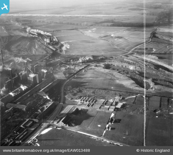
EAW013488 ENGLAND (1948). The northern end of the John Lysaght Normanby Park Steel Works site, Scunthorpe, 1948. This image was marked by Aerofilms Ltd for photo editing.
© Copyright OpenStreetMap contributors and licensed by the OpenStreetMap Foundation. 2026. Cartography is licensed as CC BY-SA.
Nearby Images (48)
EAW013488

EAW021137

EAW028570

EAW034828

EAW028571

EAW034821

EAW013834

EAW031183

EAW021138

EAW027184

EAW021136

EAW023926

EPW048946

EAW013831

EAW021132

EAW027178

EAW013833

EAW041828

EAW019673

EAW013832

EAW023925

EAW013490

EAW031173

EAW019669

EAW016662

EAW028583

EAW013489

EAW009411

EPW048529

EAW034829

EAW034811

EPW048530

EAW038776

EPW048948

EAW028575

EAW034805

EPW048528

EAW016658

EAW031193

EPW048523

EAW038778

EAW034824

EAW041846

EAW041847

EAW041863

EAW041854

EAW038775

EAW041852

Details
| Title | [EAW013488] The northern end of the John Lysaght Normanby Park Steel Works site, Scunthorpe, 1948. This image was marked by Aerofilms Ltd for photo editing. |
| Reference | EAW013488 |
| Date | 26-February-1948 |
| Link | |
| Place name | SCUNTHORPE |
| Parish | |
| District | |
| Country | ENGLAND |
| Easting / Northing | 488906, 414224 |
| Longitude / Latitude | -0.65583020052762, 53.616768921981 |
| National Grid Reference | SE889142 |
Pins
Be the first to add a comment to this image!