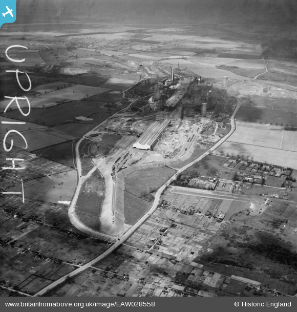
EAW028558 ENGLAND (1950). The John Lysaght Normanby Park Steel Works, Scunthorpe, from the south-east, 1950. This image was marked by Aerofilms Ltd for photo editing.
© Copyright OpenStreetMap contributors and licensed by the OpenStreetMap Foundation. 2026. Cartography is licensed as CC BY-SA.
Nearby Images (17)
Details
| Title | [EAW028558] The John Lysaght Normanby Park Steel Works, Scunthorpe, from the south-east, 1950. This image was marked by Aerofilms Ltd for photo editing. |
| Reference | EAW028558 |
| Date | 5-April-1950 |
| Link | |
| Place name | SCUNTHORPE |
| Parish | |
| District | |
| Country | ENGLAND |
| Easting / Northing | 489233, 412815 |
| Longitude / Latitude | -0.65129141243391, 53.604050902521 |
| National Grid Reference | SE892128 |
Pins
Be the first to add a comment to this image!


![[EAW028558] The John Lysaght Normanby Park Steel Works, Scunthorpe, from the south-east, 1950. This image was marked by Aerofilms Ltd for photo editing.](http://britainfromabove.org.uk/sites/all/libraries/aerofilms-images/public/100x100/EAW/028/EAW028558.jpg)
![[EAW027165] The John Lysaght Normanby Park Steel Works, Scunthorpe, 1949. This image was marked by Aerofilms Ltd for photo editing.](http://britainfromabove.org.uk/sites/all/libraries/aerofilms-images/public/100x100/EAW/027/EAW027165.jpg)
![[EAW027164] The John Lysaght Normanby Park Steel Works, Scunthorpe, 1949. This image has been produced from a print marked by Aerofilms Ltd for photo editing.](http://britainfromabove.org.uk/sites/all/libraries/aerofilms-images/public/100x100/EAW/027/EAW027164.jpg)
![[EAW021145] John Lysaght Ltd Normanby Park Steel Works (site of), Scunthorpe, from the south-east, 1949. This image has been produced from a damaged negative.](http://britainfromabove.org.uk/sites/all/libraries/aerofilms-images/public/100x100/EAW/021/EAW021145.jpg)
![[EAW019678] Allotments on the northern edge of Crosby and the Normanby Road, Scunthorpe, from the south, 1948. This image has been produced from a damaged negative.](http://britainfromabove.org.uk/sites/all/libraries/aerofilms-images/public/100x100/EAW/019/EAW019678.jpg)
![[EAW009416] Noranby Road and the John Lysaght Normanby Park Steel Works, Scunthorpe, from the east, 1947. This image has been produced from a print.](http://britainfromabove.org.uk/sites/all/libraries/aerofilms-images/public/100x100/EAW/009/EAW009416.jpg)
![[EAW009408] The John Lysaght Normanby Park Steel Works, Scunthorpe, from the south-east, 1947. This image has been produced from a print.](http://britainfromabove.org.uk/sites/all/libraries/aerofilms-images/public/100x100/EAW/009/EAW009408.jpg)
![[EAW028559] The John Lysaght Normanby Park Steel Works, Scunthorpe, from the south, 1950. This image was marked by Aerofilms Ltd for photo editing.](http://britainfromabove.org.uk/sites/all/libraries/aerofilms-images/public/100x100/EAW/028/EAW028559.jpg)
![[EAW021125] John Lysaght Ltd Normanby Park Steel Works, Scunthorpe, from the south-east, 1949. This image has been produced from a print.](http://britainfromabove.org.uk/sites/all/libraries/aerofilms-images/public/100x100/EAW/021/EAW021125.jpg)
![[EAW019680] Park Farm Road, Normanby Road and environs, Scunthorpe, 1948. This image has been produced from a print.](http://britainfromabove.org.uk/sites/all/libraries/aerofilms-images/public/100x100/EAW/019/EAW019680.jpg)
![[EAW021144] John Lysaght Ltd Normanby Park Steel Works (site of), Scunthorpe, from the south-east, 1949. This image has been produced from a damaged negative.](http://britainfromabove.org.uk/sites/all/libraries/aerofilms-images/public/100x100/EAW/021/EAW021144.jpg)
![[EAW021128] John Lysaght Ltd Normanby Park Steel Works, Scunthorpe, from the south-east, 1949. This image has been produced from a print.](http://britainfromabove.org.uk/sites/all/libraries/aerofilms-images/public/100x100/EAW/021/EAW021128.jpg)
![[EAW041832] The John Lysaght Normanby Park Steel Works, Scunthorpe, from the south, 1952. This image has been produced from a print marked by Aerofilms Ltd for photo editing.](http://britainfromabove.org.uk/sites/all/libraries/aerofilms-images/public/100x100/EAW/041/EAW041832.jpg)
![[EAW023916] The John Lysaght Normanby Park Steel Works, Scunthorpe, 1949. This image has been produced from a print marked by Aerofilms Ltd for photo editing.](http://britainfromabove.org.uk/sites/all/libraries/aerofilms-images/public/100x100/EAW/023/EAW023916.jpg)
![[EAW019679] John Lysaght Ltd Normanby Park Steel Works, Scunthorpe, from the south-west, 1948](http://britainfromabove.org.uk/sites/all/libraries/aerofilms-images/public/100x100/EAW/019/EAW019679.jpg)
![[EAW023917] The John Lysaght Normanby Park Steel Works, Scunthorpe, 1949. This image has been produced from a print marked by Aerofilms Ltd for photo editing.](http://britainfromabove.org.uk/sites/all/libraries/aerofilms-images/public/100x100/EAW/023/EAW023917.jpg)
![[EAW013493] The John Lysaght Normanby Park Steel Works, Scunthorpe, from the south-east, 1948. This image was marked by Aerofilms Ltd for photo editing.](http://britainfromabove.org.uk/sites/all/libraries/aerofilms-images/public/100x100/EAW/013/EAW013493.jpg)