
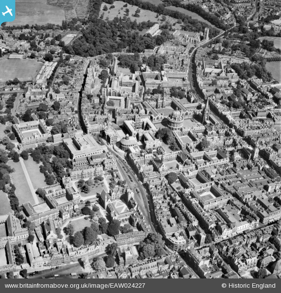
EAW024227 ENGLAND (1949). Broad Street and environs, Oxford, 1949
© Copyright OpenStreetMap contributors and licensed by the OpenStreetMap Foundation. 2026. Cartography is licensed as CC BY-SA.
Nearby Images (47)
EAW024227

EAW003112

EAW045708

EAW024228

EAW031685

EPW000839

EAW049084

EAW031684

EAW049091

EPW000827

EPW022531

EAW013598

EAW003123

EAW003122

EAW049265

EAW003118

EAW003120

EAW045709

EAW003605

EAW045716

EAW049267

EAW003934

EPW052775

EPW000847

EPW000838

EAW024226

EAW049092

EPW000846

EAW003116

EAW003113

EAW013599

EAW018725

EPW000845

EAW018723

EAW003115

EPW022524

EAW014891

EPW000849

EPW022527

EAW003125

EPW052771

EPW000848

EAW003121

EPW038410

EAW045706

EAW003119

EAW045715

Details
| Title | [EAW024227] Broad Street and environs, Oxford, 1949 |
| Reference | EAW024227 |
| Date | 27-June-1949 |
| Link | |
| Place name | OXFORD |
| Parish | |
| District | |
| Country | ENGLAND |
| Easting / Northing | 451538, 206418 |
| Longitude / Latitude | -1.2532856028594, 51.753625728561 |
| National Grid Reference | SP515064 |
Pins

Alan McFaden |
Saturday 21st of December 2013 02:39:01 PM | |
|
Alan McFaden |
Saturday 21st of December 2013 02:38:30 PM |

