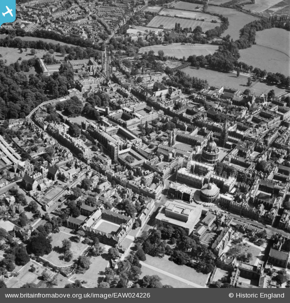
EAW024226 ENGLAND (1949). Holywell Street, Castle Street and environs, Oxford, 1949
© Copyright OpenStreetMap contributors and licensed by the OpenStreetMap Foundation. 2026. Cartography is licensed as CC BY-SA.
Nearby Images (43)
Details
| Title | [EAW024226] Holywell Street, Castle Street and environs, Oxford, 1949 |
| Reference | EAW024226 |
| Date | 27-June-1949 |
| Link | |
| Place name | OXFORD |
| Parish | |
| District | |
| Country | ENGLAND |
| Easting / Northing | 451711, 206386 |
| Longitude / Latitude | -1.2507840638177, 51.753322056812 |
| National Grid Reference | SP517064 |
Pins

Alan McFaden |
Saturday 11th of January 2014 11:28:44 AM | |

Alan McFaden |
Saturday 11th of January 2014 11:28:06 AM |


![[EAW024226] Holywell Street, Castle Street and environs, Oxford, 1949](http://britainfromabove.org.uk/sites/all/libraries/aerofilms-images/public/100x100/EAW/024/EAW024226.jpg)
![[EAW049092] The Radcliffe Camera and surrounding colleges, Oxford, 1953](http://britainfromabove.org.uk/sites/all/libraries/aerofilms-images/public/100x100/EAW/049/EAW049092.jpg)
![[EAW003120] Oxford, The Oxford Colleges and crowds gathered along the High Street for the opening of the New Bodleian Library by King George VI, 1946](http://britainfromabove.org.uk/sites/all/libraries/aerofilms-images/public/100x100/EAW/003/EAW003120.jpg)
![[EAW003605] The city, Oxford, from the north-east, 1947](http://britainfromabove.org.uk/sites/all/libraries/aerofilms-images/public/100x100/EAW/003/EAW003605.jpg)
![[EAW003934] Oxford Colleges, the city and Christ Church Meadow in flood, Oxford, from the north, 1947](http://britainfromabove.org.uk/sites/all/libraries/aerofilms-images/public/100x100/EAW/003/EAW003934.jpg)
![[EPW000846] New College area, Oxford, 1920](http://britainfromabove.org.uk/sites/all/libraries/aerofilms-images/public/100x100/EPW/000/EPW000846.jpg)
![[EPW022531] The Radcliffe Camera and surrounding Colleges, Oxford, 1928](http://britainfromabove.org.uk/sites/all/libraries/aerofilms-images/public/100x100/EPW/022/EPW022531.jpg)
![[EAW003125] Oxford, Queen's College and crowds on the High Street for the opening of the New Bodleian Library by King George VI, 1946](http://britainfromabove.org.uk/sites/all/libraries/aerofilms-images/public/100x100/EAW/003/EAW003125.jpg)
![[EAW049265] Catte Street and environs, Oxford, 1953](http://britainfromabove.org.uk/sites/all/libraries/aerofilms-images/public/100x100/EAW/049/EAW049265.jpg)
![[EAW049091] The Radcliffe Camera and surrounding colleges, Oxford, 1953](http://britainfromabove.org.uk/sites/all/libraries/aerofilms-images/public/100x100/EAW/049/EAW049091.jpg)
![[EAW049084] Broad Street and the city centre, Oxford, 1953](http://britainfromabove.org.uk/sites/all/libraries/aerofilms-images/public/100x100/EAW/049/EAW049084.jpg)
![[EPW000839] The Sheldonian Theatre, Radcliffe Camera and Colleges, Oxford, 1920](http://britainfromabove.org.uk/sites/all/libraries/aerofilms-images/public/100x100/EPW/000/EPW000839.jpg)
![[EAW049267] Holywell Street and environs, Oxford, 1953](http://britainfromabove.org.uk/sites/all/libraries/aerofilms-images/public/100x100/EAW/049/EAW049267.jpg)
![[EAW031685] The Radcliffe Library, the Bodleian Library and environs, Oxford, 1950](http://britainfromabove.org.uk/sites/all/libraries/aerofilms-images/public/100x100/EAW/031/EAW031685.jpg)
![[EAW045709] Radcliffe Square and environs, Oxford, 1952. This image has been produced from a print.](http://britainfromabove.org.uk/sites/all/libraries/aerofilms-images/public/100x100/EAW/045/EAW045709.jpg)
![[EAW045708] The Bodleian Library and environs, Oxford, 1952. This image has been produced from a print.](http://britainfromabove.org.uk/sites/all/libraries/aerofilms-images/public/100x100/EAW/045/EAW045708.jpg)
![[EPW000827] The Radcliffe Camera, Bodleian Library, All Souls College, St Mary's Church and Brasenose College, Oxford, 1920](http://britainfromabove.org.uk/sites/all/libraries/aerofilms-images/public/100x100/EPW/000/EPW000827.jpg)
![[EAW024228] Broad Street, High Street, the Radcliffe Camera and environs, Oxford, 1949](http://britainfromabove.org.uk/sites/all/libraries/aerofilms-images/public/100x100/EAW/024/EAW024228.jpg)
![[EPW000847] High Street, Oxford, 1920](http://britainfromabove.org.uk/sites/all/libraries/aerofilms-images/public/100x100/EPW/000/EPW000847.jpg)
![[EAW003604] The city centre, Oxford, from the east, 1947](http://britainfromabove.org.uk/sites/all/libraries/aerofilms-images/public/100x100/EAW/003/EAW003604.jpg)
![[EAW024227] Broad Street and environs, Oxford, 1949](http://britainfromabove.org.uk/sites/all/libraries/aerofilms-images/public/100x100/EAW/024/EAW024227.jpg)
![[EPW000838] High Street, Oxford, 1920](http://britainfromabove.org.uk/sites/all/libraries/aerofilms-images/public/100x100/EPW/000/EPW000838.jpg)
![[EPW052775] The Radcliffe Camera and surrounding Colleges, Oxford, 1937](http://britainfromabove.org.uk/sites/all/libraries/aerofilms-images/public/100x100/EPW/052/EPW052775.jpg)
![[EAW003112] Oxford, Crowds around the Radcliffe Camera for the opening of the New Bodleian Library by King George VI, 1946](http://britainfromabove.org.uk/sites/all/libraries/aerofilms-images/public/100x100/EAW/003/EAW003112.jpg)
![[EAW013598] The city, Oxford, 1948](http://britainfromabove.org.uk/sites/all/libraries/aerofilms-images/public/100x100/EAW/013/EAW013598.jpg)
![[EPW022527] The Radcliffe Camera and environs, Oxford, 1928](http://britainfromabove.org.uk/sites/all/libraries/aerofilms-images/public/100x100/EPW/022/EPW022527.jpg)
![[EAW018725] The city, Oxford, 1948. This image has been produced from a print.](http://britainfromabove.org.uk/sites/all/libraries/aerofilms-images/public/100x100/EAW/018/EAW018725.jpg)
![[EPW000825] High Street, Oxford, 1920](http://britainfromabove.org.uk/sites/all/libraries/aerofilms-images/public/100x100/EPW/000/EPW000825.jpg)
![[EAW003124] Oxford, Crowds gathered for the opening of the New Bodleian Library by King George VI, 1946](http://britainfromabove.org.uk/sites/all/libraries/aerofilms-images/public/100x100/EAW/003/EAW003124.jpg)
![[EAW003123] Oxford, Crowds gathered for the opening of the New Bodleian Library by King George VI, 1946](http://britainfromabove.org.uk/sites/all/libraries/aerofilms-images/public/100x100/EAW/003/EAW003123.jpg)
![[EAW003121] Oxford, Crowds gathered for the opening of the New Bodleian Library by King George VI, 1946](http://britainfromabove.org.uk/sites/all/libraries/aerofilms-images/public/100x100/EAW/003/EAW003121.jpg)
![[EAW031684] The Radcliffe Library, the Bodleian Library and Trinity College, Oxford, 1950](http://britainfromabove.org.uk/sites/all/libraries/aerofilms-images/public/100x100/EAW/031/EAW031684.jpg)
![[EAW003113] Oxford, Crowds gathered for the opening of the New Bodleian Library by King George VI, 1946](http://britainfromabove.org.uk/sites/all/libraries/aerofilms-images/public/100x100/EAW/003/EAW003113.jpg)
![[EPW000849] General view of the Radcliffe Camera and Colleges, Oxford, 1920](http://britainfromabove.org.uk/sites/all/libraries/aerofilms-images/public/100x100/EPW/000/EPW000849.jpg)
![[EAW003122] Oxford, The Oxford Colleges and crowds gathered for the opening of the New Bodleian Library by King George VI, from the south-east, 1946](http://britainfromabove.org.uk/sites/all/libraries/aerofilms-images/public/100x100/EAW/003/EAW003122.jpg)
![[EAW014891] The city centre, Oxford, 1948. This image has been produced from a print.](http://britainfromabove.org.uk/sites/all/libraries/aerofilms-images/public/100x100/EAW/014/EAW014891.jpg)
![[EAW013599] The city, Oxford, 1948](http://britainfromabove.org.uk/sites/all/libraries/aerofilms-images/public/100x100/EAW/013/EAW013599.jpg)
![[EAW049088] Magdalen College and environs, Oxford, 1953](http://britainfromabove.org.uk/sites/all/libraries/aerofilms-images/public/100x100/EAW/049/EAW049088.jpg)
![[EAW018723] The city, Oxford, 1948. This image has been produced from a print.](http://britainfromabove.org.uk/sites/all/libraries/aerofilms-images/public/100x100/EAW/018/EAW018723.jpg)
![[EAW018724] The city, Oxford, 1948. This image has been produced from a print.](http://britainfromabove.org.uk/sites/all/libraries/aerofilms-images/public/100x100/EAW/018/EAW018724.jpg)
![[EPW052772] Merton Field and surrounding Colleges, Oxford, 1937](http://britainfromabove.org.uk/sites/all/libraries/aerofilms-images/public/100x100/EPW/052/EPW052772.jpg)
![[EPW000826] General view of Christ Church and Radcliffe Camera, Oxford, 1920](http://britainfromabove.org.uk/sites/all/libraries/aerofilms-images/public/100x100/EPW/000/EPW000826.jpg)
![[EPW052770] The University Colleges and the city, Oxford, from the south-east, 1937](http://britainfromabove.org.uk/sites/all/libraries/aerofilms-images/public/100x100/EPW/052/EPW052770.jpg)

