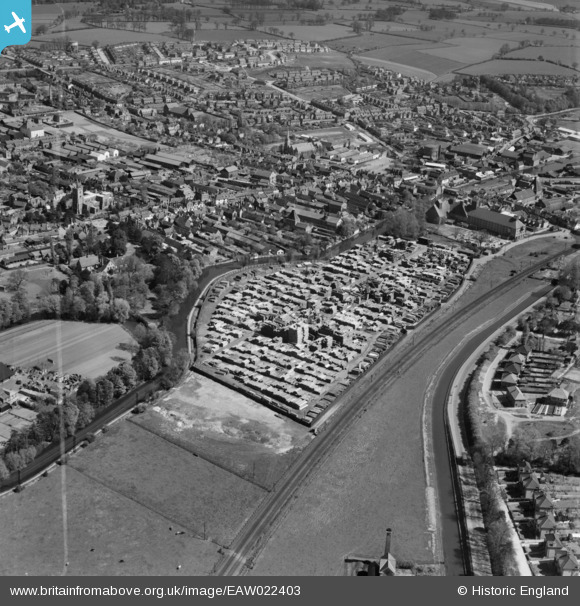
EAW022403 ENGLAND (1949). The J. Gliksten and Son Ltd timber yard next to the River Lea and environs, Ware, 1949. This image was marked by Aerofilms Ltd for photo editing.
© Copyright OpenStreetMap contributors and licensed by the OpenStreetMap Foundation. 2026. Cartography is licensed as CC BY-SA.
Nearby Images (13)
Details
| Title | [EAW022403] The J. Gliksten and Son Ltd timber yard next to the River Lea and environs, Ware, 1949. This image was marked by Aerofilms Ltd for photo editing. |
| Reference | EAW022403 |
| Date | 20-April-1949 |
| Link | |
| Place name | WARE |
| Parish | WARE |
| District | |
| Country | ENGLAND |
| Easting / Northing | 535626, 214182 |
| Longitude / Latitude | -0.032466566379621, 51.80935127978 |
| National Grid Reference | TL356142 |
Pins

Matt Aldred edob.mattaldred.com |
Sunday 2nd of March 2025 04:20:52 PM | |

Colin |
Wednesday 29th of March 2017 11:20:20 AM | |

Colin |
Wednesday 29th of March 2017 11:15:52 AM | |

Colin |
Wednesday 29th of March 2017 11:14:15 AM | |

Colin |
Wednesday 29th of March 2017 11:13:25 AM | |

Colin |
Wednesday 29th of March 2017 11:12:07 AM | |

Colin |
Wednesday 29th of March 2017 11:11:18 AM | |

Class31 |
Tuesday 27th of May 2014 08:09:41 AM | |

Class31 |
Tuesday 27th of May 2014 08:08:16 AM | |

Class31 |
Monday 26th of May 2014 09:24:03 PM |


![[EAW022403] The J. Gliksten and Son Ltd timber yard next to the River Lea and environs, Ware, 1949. This image was marked by Aerofilms Ltd for photo editing.](http://britainfromabove.org.uk/sites/all/libraries/aerofilms-images/public/100x100/EAW/022/EAW022403.jpg)
![[EAW022404] The J. Gliksten and Son Ltd timber yard next to the River Lea and environs, Ware, 1949](http://britainfromabove.org.uk/sites/all/libraries/aerofilms-images/public/100x100/EAW/022/EAW022404.jpg)
![[EAW022400] The J. Gliksten and Son Ltd timber yard next to the River Lea, Ware, 1949](http://britainfromabove.org.uk/sites/all/libraries/aerofilms-images/public/100x100/EAW/022/EAW022400.jpg)
![[EAW022399] The J. Gliksten and Son Ltd timber yard next to the River Lea, Ware, 1949. This image was marked by Aerofilms Ltd for photo editing.](http://britainfromabove.org.uk/sites/all/libraries/aerofilms-images/public/100x100/EAW/022/EAW022399.jpg)
![[EAW022401] The J. Gliksten and Son Ltd timber yard next to the River Lea and environs, Ware, from the south-east, 1949](http://britainfromabove.org.uk/sites/all/libraries/aerofilms-images/public/100x100/EAW/022/EAW022401.jpg)
![[EAW022402] The J. Gliksten and Son Ltd timber yard next to the River Lea and environs, Ware, from the south-west, 1949](http://britainfromabove.org.uk/sites/all/libraries/aerofilms-images/public/100x100/EAW/022/EAW022402.jpg)
![[EPW013340] Malthouse beside The Cut near Ware Bridge, Ware, 1925](http://britainfromabove.org.uk/sites/all/libraries/aerofilms-images/public/100x100/EPW/013/EPW013340.jpg)
![[EAW022367] Timber Yard off the River Lea and the town, Ware, 1949](http://britainfromabove.org.uk/sites/all/libraries/aerofilms-images/public/100x100/EAW/022/EAW022367.jpg)
![[EPW025935] St Mary's Church and environs, Ware, 1929](http://britainfromabove.org.uk/sites/all/libraries/aerofilms-images/public/100x100/EPW/025/EPW025935.jpg)
![[EPW013338] The town centre, Ware, 1925. This image has been produced from a copy-negative.](http://britainfromabove.org.uk/sites/all/libraries/aerofilms-images/public/100x100/EPW/013/EPW013338.jpg)
![[EPW025931] St Mary's Church and environs, Ware, 1929](http://britainfromabove.org.uk/sites/all/libraries/aerofilms-images/public/100x100/EPW/025/EPW025931.jpg)
![[EAW022366] The town, Ware, from the south-east, 1949](http://britainfromabove.org.uk/sites/all/libraries/aerofilms-images/public/100x100/EAW/022/EAW022366.jpg)
![[EPW025936] Malthouse at Amwell End, Ware, 1929](http://britainfromabove.org.uk/sites/all/libraries/aerofilms-images/public/100x100/EPW/025/EPW025936.jpg)