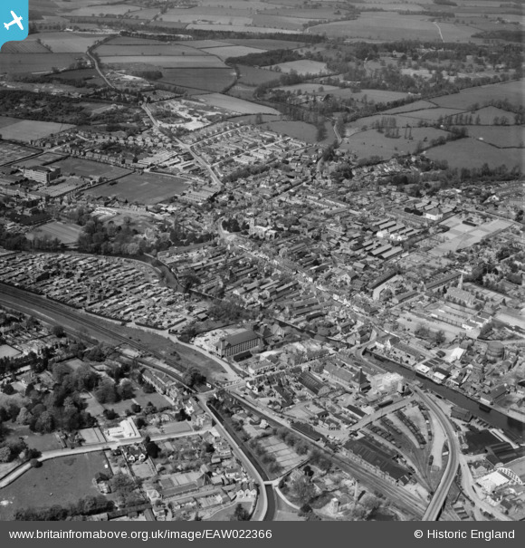
EAW022366 ENGLAND (1949). The town, Ware, from the south-east, 1949
    © Copyright OpenStreetMap contributors and licensed by the OpenStreetMap Foundation. 2025. Cartography is licensed as CC BY-SA.
  
Nearby Images (12)
Details
| Title | [EAW022366] The town, Ware, from the south-east, 1949 | 
| Reference | EAW022366 | 
| Date | 19-April-1949 | 
| Link | |
| Place name | WARE | 
| Parish | WARE | 
| District | |
| Country | ENGLAND | 
| Easting / Northing | 535857, 214103 | 
| Longitude / Latitude | -0.029148551117261, 51.808585231134 | 
| National Grid Reference | TL359141 | 
Pins
|  Site of Asda Supermarket |   Colin | Thursday 1st of August 2024 01:13:41 PM | 
|  May Savidge's house-boat Formosa |   jimbo20 | Sunday 25th of July 2021 09:59:49 AM | 
|  8 Fanshawe |   Ken Lawrence | Wednesday 29th of January 2020 03:41:03 PM | 
|  43 High Oak Road |   PaulONeill | Thursday 23rd of May 2019 02:57:14 AM | 
|  Collett Hall existed since at least the early 19th Century |   Ware Cat | Monday 22nd of October 2018 10:13:32 AM | 
|  Dean's Furnisher's - destroyed by fire 1/9/17 |   Colin | Monday 4th of September 2017 11:04:46 AM | 
| Class31 | Tuesday 19th of August 2014 05:07:29 PM | |
|  Christ Church Vicarage |   John1949 | Wednesday 6th of August 2014 01:57:32 PM | 
|  Christ Church |   John1949 | Wednesday 6th of August 2014 01:56:29 PM | 
| Class31 | Tuesday 27th of May 2014 08:28:40 AM | |
| Class31 | Monday 26th of May 2014 09:17:45 PM | |
|  Poles Lane |   Grk | Wednesday 9th of April 2014 11:53:43 AM | 
|  Poles Lane |   Grk | Wednesday 9th of April 2014 11:53:40 AM | 
|  Area developed late 1950s-mid 1960s as Kingshill Esate |   Grk | Sunday 26th of January 2014 11:05:31 AM | 
|  Big horse lane |   Grk | Sunday 26th of January 2014 11:03:33 AM | 
|  Site of Old Vicarage Estate,developed mid 1970s |   Grk | Sunday 26th of January 2014 11:02:06 AM | 
|  Canons Park farmed by Farmer Clark.Developed by Newman Ayre builders 1958-1966.Now known as Kingshill Estate. |   Grk | Friday 10th of January 2014 10:17:21 PM | 
| So was the Kingshill Estate in Ware in Hertfordshire known as Canons Park before it was developed and was just fields in the 1950's ? If so are there any newspaper reports of the area from that time referring to Canons Park |   Ware Cat | Monday 22nd of October 2018 10:23:05 AM | 
|  Milton Lodge,Milton Road |   Grk | Friday 10th of January 2014 10:15:04 PM | 
|  Braziers gravel pit,now Wulfrath Way.Built 1980s |   Grk | Friday 10th of January 2014 10:13:47 PM | 
|  Old Vicarage,burnt down late 70s - early 80s |   Grk | Friday 10th of January 2014 10:11:55 PM | 
 
             
  ![[EAW022366] The town, Ware, from the south-east, 1949](http://britainfromabove.org.uk/sites/all/libraries/aerofilms-images/public/100x100/EAW/022/EAW022366.jpg) 
  
                                          ![[EPW025936] Malthouse at Amwell End, Ware, 1929](http://britainfromabove.org.uk/sites/all/libraries/aerofilms-images/public/100x100/EPW/025/EPW025936.jpg) 
 ![[EPW013338] The town centre, Ware, 1925. This image has been produced from a copy-negative.](http://britainfromabove.org.uk/sites/all/libraries/aerofilms-images/public/100x100/EPW/013/EPW013338.jpg) 
 ![[EAW022401] The J. Gliksten and Son Ltd timber yard next to the River Lea and environs, Ware, from the south-east, 1949](http://britainfromabove.org.uk/sites/all/libraries/aerofilms-images/public/100x100/EAW/022/EAW022401.jpg) 
 ![[EAW049501] The town, Post Wood and the surrounding area, Ware, from the north, 1953](http://britainfromabove.org.uk/sites/all/libraries/aerofilms-images/public/100x100/EAW/049/EAW049501.jpg) 
 ![[EPW013340] Malthouse beside The Cut near Ware Bridge, Ware, 1925](http://britainfromabove.org.uk/sites/all/libraries/aerofilms-images/public/100x100/EPW/013/EPW013340.jpg) 
 ![[EPW025928] Works and wharfage on the River Lee, Ware, 1929](http://britainfromabove.org.uk/sites/all/libraries/aerofilms-images/public/100x100/EPW/025/EPW025928.jpg) 
 ![[EAW022399] The J. Gliksten and Son Ltd timber yard next to the River Lea, Ware, 1949. This image was marked by Aerofilms Ltd for photo editing.](http://britainfromabove.org.uk/sites/all/libraries/aerofilms-images/public/100x100/EAW/022/EAW022399.jpg) 
 ![[EAW022404] The J. Gliksten and Son Ltd timber yard next to the River Lea and environs, Ware, 1949](http://britainfromabove.org.uk/sites/all/libraries/aerofilms-images/public/100x100/EAW/022/EAW022404.jpg) 
 ![[EAW022365] The town, Ware, from the south-east, 1949](http://britainfromabove.org.uk/sites/all/libraries/aerofilms-images/public/100x100/EAW/022/EAW022365.jpg) 
 ![[EAW022403] The J. Gliksten and Son Ltd timber yard next to the River Lea and environs, Ware, 1949. This image was marked by Aerofilms Ltd for photo editing.](http://britainfromabove.org.uk/sites/all/libraries/aerofilms-images/public/100x100/EAW/022/EAW022403.jpg) 
 ![[EAW022367] Timber Yard off the River Lea and the town, Ware, 1949](http://britainfromabove.org.uk/sites/all/libraries/aerofilms-images/public/100x100/EAW/022/EAW022367.jpg)