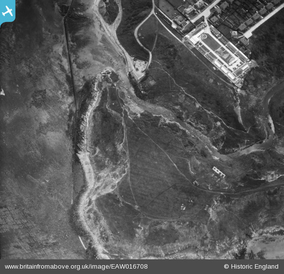
EAW016708 ENGLAND (1948). Long Nab, Scalby Ness Rocks, 1948
© Copyright OpenStreetMap contributors and licensed by the OpenStreetMap Foundation. 2026. Cartography is licensed as CC BY-SA.
Nearby Images (15)
Details
| Title | [EAW016708] Long Nab, Scalby Ness Rocks, 1948 |
| Reference | EAW016708 |
| Date | 23-June-1948 |
| Link | |
| Place name | SCALBY NESS ROCKS |
| Parish | NEWBY AND SCALBY |
| District | |
| Country | ENGLAND |
| Easting / Northing | 503592, 490984 |
| Longitude / Latitude | -0.40780585453172, 54.303785873574 |
| National Grid Reference | TA036910 |
Pins

Matt Aldred edob.mattaldred.com |
Thursday 11th of March 2021 12:40:12 PM | |

Matt Aldred edob.mattaldred.com |
Thursday 11th of March 2021 12:39:50 PM | |

redmist |
Saturday 19th of October 2019 07:24:57 PM | |

redmist |
Saturday 19th of October 2019 07:24:31 PM | |

Chris Kolonko |
Tuesday 12th of September 2017 10:08:20 PM | |

Chris Kolonko |
Tuesday 12th of September 2017 10:08:00 PM |


![[EAW016708] Long Nab, Scalby Ness Rocks, 1948](http://britainfromabove.org.uk/sites/all/libraries/aerofilms-images/public/100x100/EAW/016/EAW016708.jpg)
![[EAW016707] Long Nab, Scalby Ness Rocks, 1948](http://britainfromabove.org.uk/sites/all/libraries/aerofilms-images/public/100x100/EAW/016/EAW016707.jpg)
![[EAW016701] Long Nab and Colley's Cosy Holiday Camp, Scalby Ness Rocks, 1948](http://britainfromabove.org.uk/sites/all/libraries/aerofilms-images/public/100x100/EAW/016/EAW016701.jpg)
![[EAW016702] Long Nab and Colley's Cosy Holiday Camp, Scalby Ness Rocks, 1948](http://britainfromabove.org.uk/sites/all/libraries/aerofilms-images/public/100x100/EAW/016/EAW016702.jpg)
![[EAW016709] Long Nab, Scalby Ness Rocks, 1948](http://britainfromabove.org.uk/sites/all/libraries/aerofilms-images/public/100x100/EAW/016/EAW016709.jpg)
![[EAW016705] Long Nab, Scalby Ness Rocks, 1948](http://britainfromabove.org.uk/sites/all/libraries/aerofilms-images/public/100x100/EAW/016/EAW016705.jpg)
![[EAW016703] Long Nab, Scalby Ness Rocks, 1948](http://britainfromabove.org.uk/sites/all/libraries/aerofilms-images/public/100x100/EAW/016/EAW016703.jpg)
![[EAW016706] Long Nab and Colley's Cosy Holiday Camp, Scalby Ness Rocks, 1948](http://britainfromabove.org.uk/sites/all/libraries/aerofilms-images/public/100x100/EAW/016/EAW016706.jpg)
![[EAW016704] Long Nab, Scalby Ness Rocks, 1948](http://britainfromabove.org.uk/sites/all/libraries/aerofilms-images/public/100x100/EAW/016/EAW016704.jpg)
![[EAW010306] Colley's Cosy Camp at the end of Scholes Park Road, Scarborough, from the south-east, 1947](http://britainfromabove.org.uk/sites/all/libraries/aerofilms-images/public/100x100/EAW/010/EAW010306.jpg)
![[EAW010304] Colley's Cosy Camp at the end of Scholes Park Road, Scarborough, 1947](http://britainfromabove.org.uk/sites/all/libraries/aerofilms-images/public/100x100/EAW/010/EAW010304.jpg)
![[EAW010303] Colley's Cosy Camp at the end of Scholes Park Road, Scarborough, 1947](http://britainfromabove.org.uk/sites/all/libraries/aerofilms-images/public/100x100/EAW/010/EAW010303.jpg)
![[EAW010305] Colley's Cosy Camp at the end of Scholes Park Road, Scarborough, 1947](http://britainfromabove.org.uk/sites/all/libraries/aerofilms-images/public/100x100/EAW/010/EAW010305.jpg)
![[EAW016700] North Cliff Golf Course and Monkey Island, Scarborough, 1948](http://britainfromabove.org.uk/sites/all/libraries/aerofilms-images/public/100x100/EAW/016/EAW016700.jpg)
![[EAW010300] North Bay, Scarborough, from the north-west, 1947](http://britainfromabove.org.uk/sites/all/libraries/aerofilms-images/public/100x100/EAW/010/EAW010300.jpg)