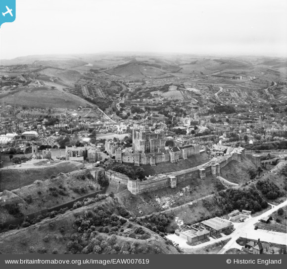
EAW007619 ENGLAND (1947). Dover Castle, Dover, from the north-east, 1947
© Copyright OpenStreetMap contributors and licensed by the OpenStreetMap Foundation. 2026. Cartography is licensed as CC BY-SA.
Nearby Images (16)
Details
| Title | [EAW007619] Dover Castle, Dover, from the north-east, 1947 |
| Reference | EAW007619 |
| Date | 28-June-1947 |
| Link | |
| Place name | DOVER |
| Parish | DOVER |
| District | |
| Country | ENGLAND |
| Easting / Northing | 632583, 141989 |
| Longitude / Latitude | 1.3245476813958, 51.129346727781 |
| National Grid Reference | TR326420 |
Pins

Alan McFaden |
Wednesday 9th of July 2014 06:11:05 PM | |
That's the Congregational Church - http://www.doversociety.org.uk/history-scrapbook/churches/congregational-church |

Doverpast |
Sunday 24th of December 2017 06:42:56 PM |

Alan McFaden |
Wednesday 9th of July 2014 06:10:34 PM | |

Alan McFaden |
Wednesday 9th of July 2014 06:09:49 PM | |

Alan McFaden |
Wednesday 9th of July 2014 06:09:11 PM |


![[EAW007619] Dover Castle, Dover, from the north-east, 1947](http://britainfromabove.org.uk/sites/all/libraries/aerofilms-images/public/100x100/EAW/007/EAW007619.jpg)
![[EAW006158] Dover Castle and environs, Dover, 1947](http://britainfromabove.org.uk/sites/all/libraries/aerofilms-images/public/100x100/EAW/006/EAW006158.jpg)
![[EAW007616] Dover Castle, Dover, from the north-east, 1947](http://britainfromabove.org.uk/sites/all/libraries/aerofilms-images/public/100x100/EAW/007/EAW007616.jpg)
![[EAW006159] Dover Castle, Dover, 1947](http://britainfromabove.org.uk/sites/all/libraries/aerofilms-images/public/100x100/EAW/006/EAW006159.jpg)
![[EPW017126] Dover Castle and the harbour, Dover, 1926](http://britainfromabove.org.uk/sites/all/libraries/aerofilms-images/public/100x100/EPW/017/EPW017126.jpg)
![[EAW007607] Dover Castle, Dover, 1947](http://britainfromabove.org.uk/sites/all/libraries/aerofilms-images/public/100x100/EAW/007/EAW007607.jpg)
![[EAW022986] Dover Castle, Dover, 1949](http://britainfromabove.org.uk/sites/all/libraries/aerofilms-images/public/100x100/EAW/022/EAW022986.jpg)
![[EPW000346] Dover Castle, St Mary's Church and the Pharos, Dover, 1920](http://britainfromabove.org.uk/sites/all/libraries/aerofilms-images/public/100x100/EPW/000/EPW000346.jpg)
![[EPW000565] St Mary's Church, Dover, from the north-east, 1920](http://britainfromabove.org.uk/sites/all/libraries/aerofilms-images/public/100x100/EPW/000/EPW000565.jpg)
![[EPW000570] The castle, Dover, 1920. This image has been produced from a copy negative.](http://britainfromabove.org.uk/sites/all/libraries/aerofilms-images/public/100x100/EPW/000/EPW000570.jpg)
![[EPW017125] Dover Castle and the harbour, Dover, 1926](http://britainfromabove.org.uk/sites/all/libraries/aerofilms-images/public/100x100/EPW/017/EPW017125.jpg)
![[EPW000345] Dover Castle, Dover, 1920](http://britainfromabove.org.uk/sites/all/libraries/aerofilms-images/public/100x100/EPW/000/EPW000345.jpg)
![[EPW000574] The castle, Dover, 1920. This image has been produced from a copy negative.](http://britainfromabove.org.uk/sites/all/libraries/aerofilms-images/public/100x100/EPW/000/EPW000574.jpg)
![[EPW000580] Dover Castle, Dover, 1920](http://britainfromabove.org.uk/sites/all/libraries/aerofilms-images/public/100x100/EPW/000/EPW000580.jpg)
![[EAW022987] Dover Castle and the Outer Harbour, Dover, 1949](http://britainfromabove.org.uk/sites/all/libraries/aerofilms-images/public/100x100/EAW/022/EAW022987.jpg)
![[EAW007620] Dover Castle, Dover, from the north-west, 1947](http://britainfromabove.org.uk/sites/all/libraries/aerofilms-images/public/100x100/EAW/007/EAW007620.jpg)


