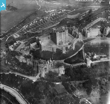
EPW000345 ENGLAND (1920). Dover Castle, Dover, 1920
© Copyright OpenStreetMap contributors and licensed by the OpenStreetMap Foundation. 2026. Cartography is licensed as CC BY-SA.
Nearby Images (14)
Details
| Title | [EPW000345] Dover Castle, Dover, 1920 |
| Reference | EPW000345 |
| Date | April-1920 |
| Link | |
| Place name | DOVER |
| Parish | DOVER |
| District | |
| Country | ENGLAND |
| Easting / Northing | 632427, 141938 |
| Longitude / Latitude | 1.3222889422249, 51.128952173718 |
| National Grid Reference | TR324419 |
Pins

The Laird |
Thursday 1st of August 2019 01:23:56 PM | |

john cotton |
Monday 11th of March 2013 01:11:23 PM | |

Class31 |
Wednesday 13th of February 2013 09:02:51 AM | |

Class31 |
Wednesday 13th of February 2013 09:00:42 AM | |

Class31 |
Wednesday 13th of February 2013 08:57:23 AM | |

Class31 |
Wednesday 13th of February 2013 08:55:32 AM |
User Comment Contributions

Cat |
Tuesday 23rd of September 2014 07:31:13 AM |


![[EPW000345] Dover Castle, Dover, 1920](http://britainfromabove.org.uk/sites/all/libraries/aerofilms-images/public/100x100/EPW/000/EPW000345.jpg)
![[EPW000570] The castle, Dover, 1920. This image has been produced from a copy negative.](http://britainfromabove.org.uk/sites/all/libraries/aerofilms-images/public/100x100/EPW/000/EPW000570.jpg)
![[EAW007607] Dover Castle, Dover, 1947](http://britainfromabove.org.uk/sites/all/libraries/aerofilms-images/public/100x100/EAW/007/EAW007607.jpg)
![[EPW000346] Dover Castle, St Mary's Church and the Pharos, Dover, 1920](http://britainfromabove.org.uk/sites/all/libraries/aerofilms-images/public/100x100/EPW/000/EPW000346.jpg)
![[EAW006159] Dover Castle, Dover, 1947](http://britainfromabove.org.uk/sites/all/libraries/aerofilms-images/public/100x100/EAW/006/EAW006159.jpg)
![[EPW000580] Dover Castle, Dover, 1920](http://britainfromabove.org.uk/sites/all/libraries/aerofilms-images/public/100x100/EPW/000/EPW000580.jpg)
![[EAW007619] Dover Castle, Dover, from the north-east, 1947](http://britainfromabove.org.uk/sites/all/libraries/aerofilms-images/public/100x100/EAW/007/EAW007619.jpg)
![[EAW006158] Dover Castle and environs, Dover, 1947](http://britainfromabove.org.uk/sites/all/libraries/aerofilms-images/public/100x100/EAW/006/EAW006158.jpg)
![[EAW007620] Dover Castle, Dover, from the north-west, 1947](http://britainfromabove.org.uk/sites/all/libraries/aerofilms-images/public/100x100/EAW/007/EAW007620.jpg)
![[EPW000574] The castle, Dover, 1920. This image has been produced from a copy negative.](http://britainfromabove.org.uk/sites/all/libraries/aerofilms-images/public/100x100/EPW/000/EPW000574.jpg)
![[EAW022986] Dover Castle, Dover, 1949](http://britainfromabove.org.uk/sites/all/libraries/aerofilms-images/public/100x100/EAW/022/EAW022986.jpg)
![[EPW017126] Dover Castle and the harbour, Dover, 1926](http://britainfromabove.org.uk/sites/all/libraries/aerofilms-images/public/100x100/EPW/017/EPW017126.jpg)
![[EAW007616] Dover Castle, Dover, from the north-east, 1947](http://britainfromabove.org.uk/sites/all/libraries/aerofilms-images/public/100x100/EAW/007/EAW007616.jpg)
![[EPW017125] Dover Castle and the harbour, Dover, 1926](http://britainfromabove.org.uk/sites/all/libraries/aerofilms-images/public/100x100/EPW/017/EPW017125.jpg)
