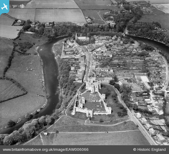
EAW006066 ENGLAND (1947). Warkworth Castle and village, Warkworth, 1947
© Copyright OpenStreetMap contributors and licensed by the OpenStreetMap Foundation. 2025. Cartography is licensed as CC BY-SA.
Nearby Images (17)
Details
| Title | [EAW006066] Warkworth Castle and village, Warkworth, 1947 |
| Reference | EAW006066 |
| Date | 21-May-1947 |
| Link | |
| Place name | WARKWORTH |
| Parish | WARKWORTH |
| District | |
| Country | ENGLAND |
| Easting / Northing | 424698, 605928 |
| Longitude / Latitude | -1.61049948375, 55.346728957069 |
| National Grid Reference | NU247059 |


![[EAW006066] Warkworth Castle and village, Warkworth, 1947](http://britainfromabove.org.uk/sites/all/libraries/aerofilms-images/public/100x100/EAW/006/EAW006066.jpg)
![[EAW041299] Warkworth Castle and the village, Warkworth, 1951](http://britainfromabove.org.uk/sites/all/libraries/aerofilms-images/public/100x100/EAW/041/EAW041299.jpg)
![[EAW006063] Warkworth Castle and village, Warkworth, 1947](http://britainfromabove.org.uk/sites/all/libraries/aerofilms-images/public/100x100/EAW/006/EAW006063.jpg)
![[EPW038810] The village, Warkworth, 1932](http://britainfromabove.org.uk/sites/all/libraries/aerofilms-images/public/100x100/EPW/038/EPW038810.jpg)
![[EAW008924] Warkworth Castle, Warkworth, 1947. This image has been produced from a print.](http://britainfromabove.org.uk/sites/all/libraries/aerofilms-images/public/100x100/EAW/008/EAW008924.jpg)
![[EAW041298] Warkworth Castle and the village, Warkworth, 1951](http://britainfromabove.org.uk/sites/all/libraries/aerofilms-images/public/100x100/EAW/041/EAW041298.jpg)
![[EPW038814] Warkworth Castle, Warkworth, 1932. This image has been produced from a copy-negative.](http://britainfromabove.org.uk/sites/all/libraries/aerofilms-images/public/100x100/EPW/038/EPW038814.jpg)
![[EAW008922] Warkworth Castle, Warkworth, 1947. This image has been produced from a print.](http://britainfromabove.org.uk/sites/all/libraries/aerofilms-images/public/100x100/EAW/008/EAW008922.jpg)
![[EAW008923] Warkworth Castle, Warkworth, 1947. This image has been produced from a print.](http://britainfromabove.org.uk/sites/all/libraries/aerofilms-images/public/100x100/EAW/008/EAW008923.jpg)
![[EAW006062] Warkworth Castle and environs, Warkworth, 1947. This image was marked by Aerofilms Ltd for photo editing.](http://britainfromabove.org.uk/sites/all/libraries/aerofilms-images/public/100x100/EAW/006/EAW006062.jpg)
![[EAW006065] Warkworth Castle and environs, Warkworth, 1947](http://britainfromabove.org.uk/sites/all/libraries/aerofilms-images/public/100x100/EAW/006/EAW006065.jpg)
![[EAW008920] Warkworth Castle, Warkworth, 1947](http://britainfromabove.org.uk/sites/all/libraries/aerofilms-images/public/100x100/EAW/008/EAW008920.jpg)
![[EPW038808] Warkworth Castle, Warkworth, 1932](http://britainfromabove.org.uk/sites/all/libraries/aerofilms-images/public/100x100/EPW/038/EPW038808.jpg)
![[EAW008921] Warkworth Castle, Warkworth, 1947. This image has been produced from a print.](http://britainfromabove.org.uk/sites/all/libraries/aerofilms-images/public/100x100/EAW/008/EAW008921.jpg)
![[EAW006064] Warkworth Castle and environs, Warkworth, 1947. This image was marked by Aerofilms Ltd for photo editing.](http://britainfromabove.org.uk/sites/all/libraries/aerofilms-images/public/100x100/EAW/006/EAW006064.jpg)
![[EAW006067] Warkworth Castle and environs, Warkworth, 1947](http://britainfromabove.org.uk/sites/all/libraries/aerofilms-images/public/100x100/EAW/006/EAW006067.jpg)
![[EPW038813] St Lawrence's Church and environs, Warkworth, 1932](http://britainfromabove.org.uk/sites/all/libraries/aerofilms-images/public/100x100/EPW/038/EPW038813.jpg)
