
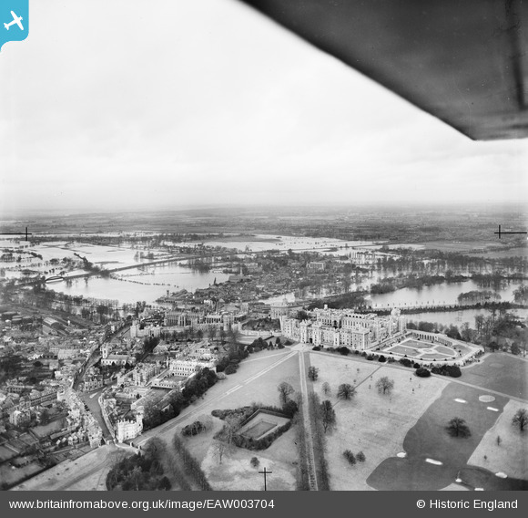
EAW003704 ENGLAND (1947). Windsor Castle and the surrounding flooded area, Windsor, from the south, 1947
© Copyright OpenStreetMap contributors and licensed by the OpenStreetMap Foundation. 2026. Cartography is licensed as CC BY-SA.
Nearby Images (47)
EAW003704

EAW021007

EPW046518

EAW003703

EPW046522

EPW005692

EPW005693

EAW003781

EPW022598

EAW003705

EAW053001

EPW046517

EPW046520

EPW046519

EPW053888

EAW004840

EPW046521

EAW038574

EPW056591

EAW004843

EPW034873

EPW056592

EAW004842

EPW056590

EPW053886

EPW034874

EAW026474

EAW004844

EPW005691

EPW034876

EAW003663

EPW022601

EPW034875

EPW005694

EPW022606

EPW053885

EPW022600

EAW004841

EPW053887

EPW022599

EPR000457

EAW006324

EAW052997

EPW012468

EAW006323

EAW053000

EPW012471

Details
| Title | [EAW003704] Windsor Castle and the surrounding flooded area, Windsor, from the south, 1947 |
| Reference | EAW003704 |
| Date | 18-March-1947 |
| Link | |
| Place name | WINDSOR |
| Parish | |
| District | |
| Country | ENGLAND |
| Easting / Northing | 497074, 176851 |
| Longitude / Latitude | -0.60188784061226, 51.481787731503 |
| National Grid Reference | SU971769 |
Pins

Matt Aldred edob.mattaldred.com |
Wednesday 13th of May 2020 08:55:33 PM | |

Alan McFaden |
Tuesday 14th of January 2014 03:37:19 PM |
