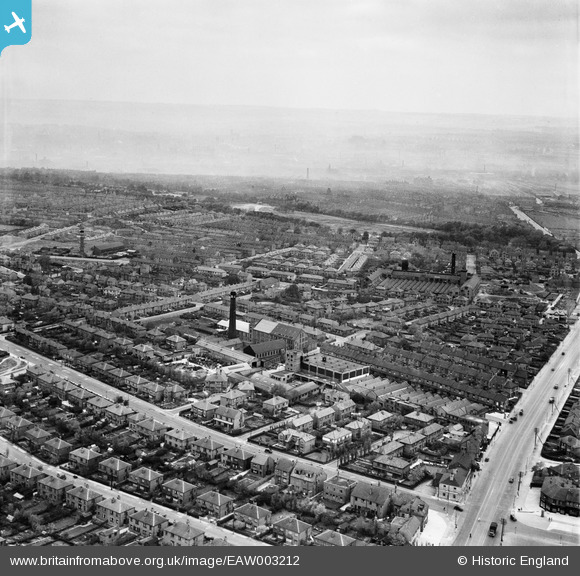
EAW003212 ENGLAND (1946). Residential streets surrounding Grove Hall Mills, Beeston, from the south-west, 1946
© Copyright OpenStreetMap contributors and licensed by the OpenStreetMap Foundation. 2026. Cartography is licensed as CC BY-SA.
Nearby Images (18)
Details
| Title | [EAW003212] Residential streets surrounding Grove Hall Mills, Beeston, from the south-west, 1946 |
| Reference | EAW003212 |
| Date | 18-October-1946 |
| Link | |
| Place name | BEESTON |
| Parish | |
| District | |
| Country | ENGLAND |
| Easting / Northing | 428958, 430060 |
| Longitude / Latitude | -1.5606450655641, 53.765864203038 |
| National Grid Reference | SE290301 |


![[EAW003212] Residential streets surrounding Grove Hall Mills, Beeston, from the south-west, 1946](http://britainfromabove.org.uk/sites/all/libraries/aerofilms-images/public/100x100/EAW/003/EAW003212.jpg)
![[EAW003207] Grove Hall Mills and environs, Beeston, from the south-east, 1946](http://britainfromabove.org.uk/sites/all/libraries/aerofilms-images/public/100x100/EAW/003/EAW003207.jpg)
![[EAW003215] Grove Hall Mills and environs, Beeston, 1946](http://britainfromabove.org.uk/sites/all/libraries/aerofilms-images/public/100x100/EAW/003/EAW003215.jpg)
![[EAW003214] Grove Hall Mills and environs, Beeston, 1946](http://britainfromabove.org.uk/sites/all/libraries/aerofilms-images/public/100x100/EAW/003/EAW003214.jpg)
![[EAW002618] The Forgrove Machinery Co Works off Dewsbury Road and the surrounding residential area, Leeds, 1946](http://britainfromabove.org.uk/sites/all/libraries/aerofilms-images/public/100x100/EAW/002/EAW002618.jpg)
![[EAW002620] The Forgrove Machinery Co Works off Dewsbury Road and the surrounding residential area, Leeds, 1946](http://britainfromabove.org.uk/sites/all/libraries/aerofilms-images/public/100x100/EAW/002/EAW002620.jpg)
![[EAW003210] Oakhurst Avenue, Grove Hall Mills and environs, Beeston, from the south-east, 1946](http://britainfromabove.org.uk/sites/all/libraries/aerofilms-images/public/100x100/EAW/003/EAW003210.jpg)
![[EAW003217] Grove Hall Mills and environs, Beeston, from the south-east, 1946](http://britainfromabove.org.uk/sites/all/libraries/aerofilms-images/public/100x100/EAW/003/EAW003217.jpg)
![[EAW003213] Grove Hall Mills and environs, Beeston, 1946](http://britainfromabove.org.uk/sites/all/libraries/aerofilms-images/public/100x100/EAW/003/EAW003213.jpg)
![[EAW003211] Dewsbury Road, Grove Hall Mills and environs, Beeston, from the north-east, 1946](http://britainfromabove.org.uk/sites/all/libraries/aerofilms-images/public/100x100/EAW/003/EAW003211.jpg)
![[EAW003208] Old Lane, Grove Hall Mills and environs, Beeston, from the south-east, 1946](http://britainfromabove.org.uk/sites/all/libraries/aerofilms-images/public/100x100/EAW/003/EAW003208.jpg)
![[EAW002619] The Forgrove Machinery Co Works off Dewsbury Road and the surrounding residential area, Leeds, 1946](http://britainfromabove.org.uk/sites/all/libraries/aerofilms-images/public/100x100/EAW/002/EAW002619.jpg)
![[EAW003206] Residential streets surrounding Grove Hall Mills, Beeston, from the north-east, 1946](http://britainfromabove.org.uk/sites/all/libraries/aerofilms-images/public/100x100/EAW/003/EAW003206.jpg)
![[EAW003218] Grove Hall Mills and environs, Beeston, from the north, 1946](http://britainfromabove.org.uk/sites/all/libraries/aerofilms-images/public/100x100/EAW/003/EAW003218.jpg)
![[EAW003216] Residential streets surrounding Grove Hall Mills, Beeston, from the north-west, 1946](http://britainfromabove.org.uk/sites/all/libraries/aerofilms-images/public/100x100/EAW/003/EAW003216.jpg)
![[EAW003209] Grovehall Drive, Grove Hall Mills and environs, Beeston, from the north, 1946](http://britainfromabove.org.uk/sites/all/libraries/aerofilms-images/public/100x100/EAW/003/EAW003209.jpg)
![[EAW002617] The Forgrove Machinery Co Works off Dewsbury Road and the surrounding residential area, Leeds, from the south-east, 1946](http://britainfromabove.org.uk/sites/all/libraries/aerofilms-images/public/100x100/EAW/002/EAW002617.jpg)
![[EAW051499] William Moorhouse & Sons Ltd Sunglow Model Factory on Old Lane and environs, Beeston, 1953. This image was marked by Aerofilms Ltd for photo editing.](http://britainfromabove.org.uk/sites/all/libraries/aerofilms-images/public/100x100/EAW/051/EAW051499.jpg)
