
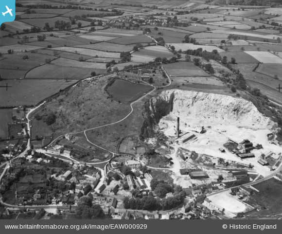
EAW000929 ENGLAND (1946). The Breedon Lime Works and St Mary & St Hardulph's Church, Breedon on the Hill, 1946. This image has been produced from a print.
© Copyright OpenStreetMap contributors and licensed by the OpenStreetMap Foundation. 2026. Cartography is licensed as CC BY-SA.
Nearby Images (19)
EAW000929

EPW062142

EPW062141

EAW000935

EPW062140

EAW000941

EAW001668

EPW062139

EPW062143

EAW001701

EAW000942

EAW001700

EAW000943

EAW001699

EPW062144

EAW000940

EAW001697

EAW001698

EAW000937

Details
| Title | [EAW000929] The Breedon Lime Works and St Mary & St Hardulph's Church, Breedon on the Hill, 1946. This image has been produced from a print. |
| Reference | EAW000929 |
| Date | 29-May-1946 |
| Link | |
| Place name | BREEDON ON THE HILL |
| Parish | BREEDON ON THE HILL |
| District | |
| Country | ENGLAND |
| Easting / Northing | 440568, 323135 |
| Longitude / Latitude | -1.3981652227321, 52.803910560376 |
| National Grid Reference | SK406231 |
Pins
Be the first to add a comment to this image!