
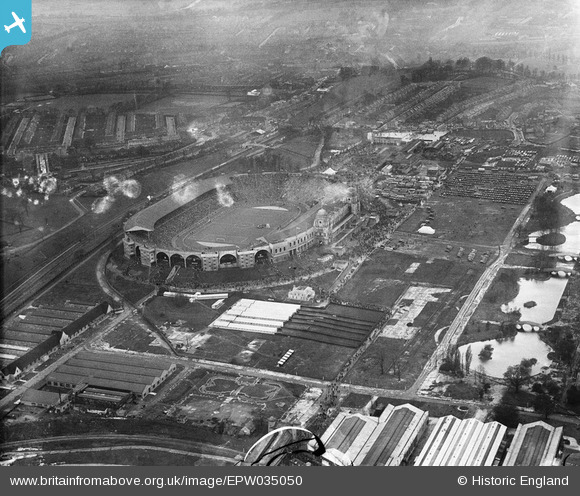
EPW035050 ENGLAND (1931). Wembley Park, Wembley Stadium and environs before the start of the Cup Final between West Bromwich Albion and Birmingham, 1931
© Hawlfraint cyfranwyr OpenStreetMap a thrwyddedwyd gan yr OpenStreetMap Foundation. 2026. Trwyddedir y gartograffeg fel CC BY-SA.
Delweddau cyfagos (48)
EAW048875

EAW048879

EPW010455

EPW020865

EPW008076
 under construction, Wembley Park, from the north-west, 1922. This image has been produced from a copy-negative.")
EPW017630

EPW012730

EPW012726

EAW048878

EPW008545
, Wembley Park, 1923. This image has been produced from a copy-negative.")
EPW046909

EPW017636

EPW046905

EPW011412

EPW017635

EPW020862

EPW009655

EPW010462

EPW046913

EPW026433

EPW046907

EPW010456

EPW026431

EPW026438

EAW014141
 Stadium, Wembley Park, 1948. This image has been produced from a damaged negative.")
EAW018311

EAW018313

EPW010461

EAW038566
 at Wembley Stadium, 1951. This image has been produced from a print.")
EPW034581

EAW018312

EPW010458

EPW010459

EPW010457

EAW017618

EPW010460

EPW026434

EPW020341

EPW017623

EAW017619

EAW017617

EPW046910

EPW009806

EPW040769

EPW009652

EAW038567
 at Wembley Stadium, 1951. This image has been produced from a print.")
EPW012752

EPW009602

Manylion
| Pennawd | [EPW035050] Wembley Park, Wembley Stadium and environs before the start of the Cup Final between West Bromwich Albion and Birmingham, 1931 |
| Cyfeirnod | EPW035050 |
| Dyddiad | 25-April-1931 |
| Dolen | |
| Enw lle | WEMBLEY PARK |
| Plwyf | |
| Ardal | |
| Gwlad | ENGLAND |
| Dwyreiniad / Gogleddiad | 519440, 185552 |
| Hydred / Lledred | -0.27695287789805, 51.555714491308 |
| Cyfeirnod Grid Cenedlaethol | TQ194856 |
Pinnau
Byddwch y cyntaf i ychwanegu sylw at y ddelwedd hon!