
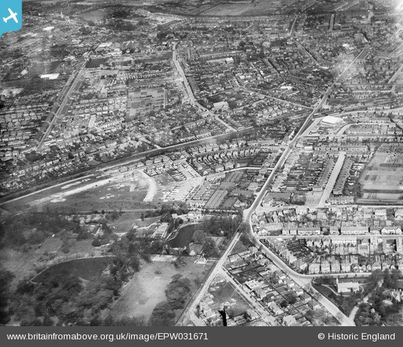
EPW031671 ENGLAND (1930). Argyle Avenue and environs, Hounslow, from the south, 1930
© Hawlfraint cyfranwyr OpenStreetMap a thrwyddedwyd gan yr OpenStreetMap Foundation. 2026. Trwyddedir y gartograffeg fel CC BY-SA.
Manylion
| Pennawd | [EPW031671] Argyle Avenue and environs, Hounslow, from the south, 1930 |
| Cyfeirnod | EPW031671 |
| Dyddiad | April-1930 |
| Dolen | |
| Enw lle | HOUNSLOW |
| Plwyf | |
| Ardal | |
| Gwlad | ENGLAND |
| Dwyreiniad / Gogleddiad | 513797, 174460 |
| Hydred / Lledred | -0.3619023361851, 51.457177438645 |
| Cyfeirnod Grid Cenedlaethol | TQ138745 |
Pinnau

J |
Tuesday 11th of February 2025 01:51:19 AM | |
|
Leslie B |
Wednesday 23rd of August 2017 04:24:26 PM | |
|
Leslie B |
Wednesday 23rd of August 2017 04:20:39 PM | |
|
Leslie B |
Wednesday 23rd of August 2017 04:14:47 PM | |
|
Leslie B |
Wednesday 23rd of August 2017 04:05:04 PM | |
|
stephenrigby |
Tuesday 1st of January 2013 03:12:47 PM | |
Old Maps show it as Argyle House. It appears to have been demolished not long after this picture was taken. |
Tony D |
Tuesday 1st of January 2013 05:56:34 PM |

Cyfraniadau Grŵp
It is noted as Argyle House on a 1915 map. On a 1895 map the house has yet to be built and on a subsequent 1934 map the house has been replaced by 3 pairs of semi-detached houses. |
ColinM |
Wednesday 16th of October 2013 04:19:38 PM |