
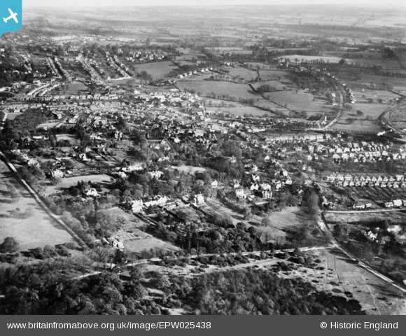
EPW025438 ENGLAND (1928). Warren Road, Albion Hill and environs, Loughton, from the south-west, 1928. This image has been produced from a copy-negative.
© Hawlfraint cyfranwyr OpenStreetMap a thrwyddedwyd gan yr OpenStreetMap Foundation. 2026. Trwyddedir y gartograffeg fel CC BY-SA.
Manylion
| Pennawd | [EPW025438] Warren Road, Albion Hill and environs, Loughton, from the south-west, 1928. This image has been produced from a copy-negative. |
| Cyfeirnod | EPW025438 |
| Dyddiad | November-1928 |
| Dolen | |
| Enw lle | LOUGHTON |
| Plwyf | LOUGHTON |
| Ardal | |
| Gwlad | ENGLAND |
| Dwyreiniad / Gogleddiad | 541378, 195554 |
| Hydred / Lledred | 0.043357817574757, 51.640527035904 |
| Cyfeirnod Grid Cenedlaethol | TQ414956 |
Pinnau

somoody |
Tuesday 20th of May 2025 03:36:15 PM | |
|
somoody |
Tuesday 20th of May 2025 03:33:30 PM | |
|
somoody |
Tuesday 20th of May 2025 03:32:18 PM | |
|
somoody |
Tuesday 20th of May 2025 03:31:25 PM | |
|
somoody |
Tuesday 20th of May 2025 03:30:20 PM | |
|
somoody |
Tuesday 20th of May 2025 03:28:26 PM | |
|
somoody |
Tuesday 20th of May 2025 03:27:17 PM | |
|
somoody |
Tuesday 20th of May 2025 03:25:59 PM | |
|
somoody |
Tuesday 20th of May 2025 03:23:42 PM | |
|
somoody |
Tuesday 20th of May 2025 03:23:00 PM | |
|
somoody |
Tuesday 20th of May 2025 03:22:00 PM | |
|
somoody |
Tuesday 20th of May 2025 03:21:29 PM |