
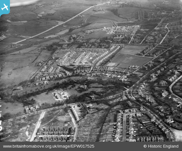
EPW017525 ENGLAND (1927). Housing under construction, Crumpsall, 1927
© Hawlfraint cyfranwyr OpenStreetMap a thrwyddedwyd gan yr OpenStreetMap Foundation. 2026. Trwyddedir y gartograffeg fel CC BY-SA.
Manylion
| Pennawd | [EPW017525] Housing under construction, Crumpsall, 1927 |
| Cyfeirnod | EPW017525 |
| Dyddiad | March-1927 |
| Dolen | |
| Enw lle | CRUMPSALL |
| Plwyf | |
| Ardal | |
| Gwlad | ENGLAND |
| Dwyreiniad / Gogleddiad | 383203, 402592 |
| Hydred / Lledred | -2.2533650789666, 53.51948418648 |
| Cyfeirnod Grid Cenedlaethol | SD832026 |
Pinnau

Crispin Edwards |
Monday 11th of May 2026 06:17:44 PM | |
|
Crispin Edwards |
Monday 11th of May 2026 06:17:12 PM | |
|
Crispin Edwards |
Monday 11th of May 2026 06:03:45 PM | |
|
Crispin Edwards |
Monday 11th of May 2026 06:03:12 PM | |
|
john |
Tuesday 7th of February 2023 10:42:29 AM | |
|
john |
Tuesday 7th of February 2023 10:41:01 AM | |
|
john |
Tuesday 7th of February 2023 10:37:09 AM | |
|
edqdpmad |
Friday 30th of May 2014 10:41:53 PM | |
|
edqdpmad |
Friday 30th of May 2014 10:39:34 PM | |
|
edqdpmad |
Friday 30th of May 2014 10:38:48 PM | |
|
edqdpmad |
Friday 30th of May 2014 10:38:14 PM | |
|
edqdpmad |
Friday 30th of May 2014 10:37:05 PM | |
|
edqdpmad |
Friday 30th of May 2014 10:36:38 PM | |
|
Andy Williams |
Sunday 23rd of March 2014 09:14:42 PM | |
|
Andy Williams |
Sunday 23rd of March 2014 09:09:03 PM | |
|
Andy Williams |
Sunday 23rd of March 2014 09:07:07 PM | |
|
Andy Williams |
Sunday 23rd of March 2014 09:04:01 PM | |
|
OldiePhil |
Tuesday 18th of June 2013 10:29:00 AM |
Cyfraniadau Grŵp
Well spotted Prestwichian.I can confirm all you say as i was a taxi driver in this area. The King Billy fishing pond can be clearly seen as the small triangular shape half way along Blackley New Rd in the top left of the picture. Of course the houses round the pond on Elbourne Rd estate had not been built at that time. |
alkinez |
Wednesday 20th of February 2013 08:51:11 PM |
Bury Old Road crosses the picture from bottom left to middle right. Singleton Road spurs off to bottom right? In the foreground to the left is Hardman Avenue and a half built Wilton Road (evens only) both connecting Kings Road and Albert Avenue to the left and right respectively. Crossing Bury Old Road from Albert Ave is Danesway. The large house to the right of Danesway looks interesting, that is where Ravensway is now built. Park Road is in the centre of the picture and, further up, Middleton Road crosses the picture. Blackley New Road is the wide road at the top of the picture. My house is on this picture but the the land register says it was built in 1935! |
Prestwichian |
Wednesday 11th of July 2012 11:22:39 PM |