
EPW017453 ENGLAND (1927). Heyes Lane and environs, Timperley, 1927
© Hawlfraint cyfranwyr OpenStreetMap a thrwyddedwyd gan yr OpenStreetMap Foundation. 2026. Trwyddedir y gartograffeg fel CC BY-SA.
Manylion
| Pennawd | [EPW017453] Heyes Lane and environs, Timperley, 1927 |
| Cyfeirnod | EPW017453 |
| Dyddiad | 8-March-1927 |
| Dolen | |
| Enw lle | TIMPERLEY |
| Plwyf | |
| Ardal | |
| Gwlad | ENGLAND |
| Dwyreiniad / Gogleddiad | 378640, 389700 |
| Hydred / Lledred | -2.3213158692469, 53.403427470076 |
| Cyfeirnod Grid Cenedlaethol | SJ786897 |
Pinnau
 |

JessFro |
Sunday 12th of April 2020 04:01:08 PM |
|
Auld_Timp |
Tuesday 11th of September 2018 04:27:09 PM | |
|
Auld_Timp |
Thursday 1st of March 2018 10:38:46 AM | |
When I lived thereabouts, Heyes Lane - which appears, at that end furthest from Park Road, to have originally been merely an access track to 'Far Heyes' - stopped at the junction of Wood Road, which, to judge from the picture, looks as if it was roughly where 'Far Heyes' once stood. At that point the name changed, as you say, to Woodhouse Lane East. Of course, nothing of that was there in 1927 when this photo was taken. But as a youngster I heard exactly the same story as the one you tell here: that Woodhouse Lane East is exactly aligned to Eastway and then to Woodhouse Lane, across the A56 at the Woodheys end of Sale, as the beginning of a projected new road over canal and railway, and that this was the reason why Eastway was built so curiously wide, for what ultimately never became anything more than a suburban side road. I seem to remember being told this was a plan hatched in the early 1930s as motorized traffic was steadily increasing. But as you say, it never happened, and I don't recall any mention of it being revived during the time that I was growing up there in the '50s and early '60s. Unlike the replacement of the footbridge with a road bridge linking the two parts of Wood Road, which was mooted at least three times during my childhood and teenage years. But that, of course, never happened either; given the narrowness of adjacent roads and the sheer volume of traffic these days, probably just as well! |
John Ellis |
Sunday 29th of April 2018 10:49:34 AM |
|
John Ellis |
Tuesday 21st of January 2014 07:01:50 PM | |
Hi All, Does anyone know the history of the 2 big semi detached houses opposite the old Heysleigh Annexe red cross hospital on Heyes Lane, I think they are No 27 & 29. Thanks |
Jimjiminy100 |
Friday 14th of February 2020 09:22:46 PM |
|
John Ellis |
Friday 20th of December 2013 05:08:43 PM | |
|
John Ellis |
Saturday 11th of August 2012 12:51:40 PM | |
It's occurred to me that the bit of the original Heyes Lane at this point is known - or was when I was a kid - as Old Heyes Road, which suggests that "the Heyes" might have been the original and oldest house in the area, but that the house had already been pulled down when the line of late Victorian terraced cottages which comprise the road were built. |
John Ellis |
Saturday 18th of January 2014 11:11:43 AM |
|
John Ellis |
Sunday 5th of August 2012 11:06:01 PM | |
hello, I'm looking for info going back on olive cottage, should you be able to share with me what you know? |
Spencer |
Sunday 15th of March 2026 10:49:56 PM |
|
John Ellis |
Friday 27th of July 2012 04:20:07 PM | |
|
John Ellis |
Friday 27th of July 2012 04:19:16 PM | |
|
John Ellis |
Friday 27th of July 2012 04:17:38 PM | |
|
John Ellis |
Friday 27th of July 2012 04:14:17 PM | |
|
John Ellis |
Friday 27th of July 2012 04:10:59 PM | |
|
John Ellis |
Friday 27th of July 2012 04:09:57 PM | |
|
John Ellis |
Friday 27th of July 2012 04:08:38 PM | |
|
John Ellis |
Friday 27th of July 2012 04:06:13 PM | |
|
John Ellis |
Friday 27th of July 2012 04:05:39 PM | |
|
John Ellis |
Friday 27th of July 2012 04:04:21 PM | |
|
Hazel Pryor |
Tuesday 17th of July 2012 02:53:29 PM | |
- known in the 1870s as Mount Pleasant. |
John Ellis |
Sunday 5th of August 2012 11:04:33 PM |
|
Hazel Pryor |
Tuesday 17th of July 2012 02:52:31 PM | |
I remember that path well, by the 1960s it connected Heyes Lane with the Grange Estate. There was an underground "den" dug out near the Grange end, when I was 9 or 10 my mate and I dared to explore it, then the "owners" happened upon us and closed off the entrance! We were terrified and pled for our lives - they relented and let us go (running!) after what was probably minutes, but felt like hours! |
JH |
Saturday 29th of December 2012 09:15:40 PM |
|
John Ellis |
Friday 13th of July 2012 08:14:06 PM | |
|
John Ellis |
Friday 13th of July 2012 08:12:28 PM | |
|
John Ellis |
Friday 13th of July 2012 08:11:23 PM | |
|
John Ellis |
Friday 13th of July 2012 08:08:44 PM | |
|
John Ellis |
Friday 13th of July 2012 08:07:51 PM | |
|
John Ellis |
Friday 13th of July 2012 08:07:09 PM | |
|
paul296 |
Friday 13th of July 2012 04:06:11 PM | |
Was that the old farm just north of the Stonemason's Arms, but on the opposite side of the road? I remember this farm in the late '50s/early '60s - not much land left beyond the farmyard, but I recall they used to have a sign offering eggs for sale. The (then) new parade of lock-up shops was built alongside it. |
John Ellis |
Friday 13th of July 2012 06:15:53 PM |
|
paul296 |
Friday 13th of July 2012 04:03:06 PM | |
Back in the mid-'50s, they used to employ a groundsman on Smith's Field who used to walk to and from work past the end of our road. He had one vivid pale blue eye, and one dark brown one, something I'd never seen before - or since, for that matter. We kids (we were about 9 or 10 at the time) used to stare at him in wonder - very rudely, I suppose, but quite innocently! |
John Ellis |
Friday 13th of July 2012 07:05:24 PM |
|
John Ellis |
Friday 13th of July 2012 01:08:59 AM | |
|
John Ellis |
Friday 13th of July 2012 01:06:20 AM | |
Heyes Lane didn't extend northward along its present line beyond what is now the junction with Oakdene Road and what Hazel Pryor calls "the Boggart path" (though I'd never heard it called that!) until some time towards the end of the 19th century or perhaps the very start of the 20th. Before then, it took a sharp turn left, and what is now Oakdene Road was Heyes Lane; and it carried on past Heyes Terrace to end, at first, near Heyes View and later was extended to serve Far Heyes when that was built. My guess is that Heyes Lane was extended on its present line when the houses immediately north of the present junction with Oakdene Road were built - if I remember them rightly, they look as if they were built at around that time. The name "Heyes Lane" seems to relate to a house or farm called "the Heyes" or "the Heys" which appears to have stood roughly where Crofton Avenue now meets Marsland Avenue. It appears from the photograph that "the Heyes" had already been demolished by 1927, even before all the housing development took place. |
John Ellis |
Saturday 11th of August 2012 12:55:07 PM |
|
John Ellis |
Friday 13th of July 2012 12:27:30 AM | |
|
JH |
Monday 9th of July 2012 06:39:25 PM | |
It was Constable's in the early '50s too, when I first remember it. The 1875 OS map marks the cottages of which it was part as "Chapelhouses" - perhaps a reference to the Congregational chapel, though I don't know how old that is. The present, fairly modern, church was as it is now in the 1950s, but there may have been an older chapel before it. |
John Ellis |
Friday 13th of July 2012 01:03:03 AM |
Constables in the 1940s, too |
oldhall |
Friday 14th of June 2013 04:33:30 PM |
It was Constable's in the 1940's. It had a high (for a small child) polished wooden counter. It seemed small and cosy inside. Close by (next door?) on Park road, were some old cottages. I remember passing them one day and saw into one of them as the door was wide open, and there was a floral wallpaper which startled me as it seemed the flowers were so big for such a tiny old cottage. They looked like pink cabbages. |
Jean |
Saturday 13th of September 2014 03:45:54 AM |
|
John Ellis |
Tuesday 3rd of July 2012 06:15:14 PM | |
|
John Ellis |
Tuesday 3rd of July 2012 06:11:26 PM | |
...also known as Stoney Bridge. |
Paul |
Sunday 4th of December 2016 06:20:00 AM |
|
John Ellis |
Tuesday 3rd of July 2012 06:09:51 PM | |
|
John Ellis |
Tuesday 3rd of July 2012 06:09:01 PM | |
|
John Ellis |
Tuesday 3rd of July 2012 06:05:59 PM | |
|
John Ellis |
Tuesday 3rd of July 2012 06:04:43 PM | |
|
John Ellis |
Monday 2nd of July 2012 09:43:12 PM | |
- known in the 1870s as The Hollins Farm |
John Ellis |
Sunday 5th of August 2012 10:59:21 PM |
|
John Ellis |
Sunday 1st of July 2012 11:18:02 AM | |
|
John Ellis |
Sunday 1st of July 2012 11:13:35 AM | |
|
John Ellis |
Sunday 1st of July 2012 11:12:32 AM | |
|
John Ellis |
Sunday 1st of July 2012 11:12:03 AM | |
|
John Ellis |
Sunday 1st of July 2012 11:11:05 AM | |
|
John Ellis |
Saturday 30th of June 2012 10:51:21 PM | |
|
LJones |
Thursday 28th of June 2012 08:46:02 PM | |
|
LJones |
Thursday 28th of June 2012 08:44:55 PM | |
|
JH |
Thursday 28th of June 2012 06:45:59 AM | |
It was demolished in the spring of 1964. Most of the Riddings Road estate is pre-war, but the top of Heyes Lane - the end furthest from Park Road - remained for the most part agricultural land until rather later. Heyes Lane primary school was built on part of that land in the early 1950s, along with a ribbon of houses between the school and Riddings Road. That left Wilford and Fairlea, both nurseries/market gardens, and a small poultry farm just near the bend of Heyes Lane on the opposite side to Heyes View, which had a small lake on its land. All these succumbed to the developer at the same time as Wilford. Fairlea was run by the Horsfield family; Wilford by a guy called Wilson. His first name may have been Leonard - but memory gets vague after nearly fifty years ... ! |
John Ellis |
Sunday 1st of July 2012 11:04:42 AM |
I've been toggling between a current Google Map view and this. I know the newer houses you mean at the top end of Heyes Lane (in fact I remember Heyes Lane still being a dirt track at the top end, near the back of the school, in the 1960s. But given that the old (farm?) house on the photo is much nearer to Park Road, surely it sits somewhere around Arderne Road, and must therefore have been demolished by the 30s? |
JH |
Monday 9th of July 2012 06:49:10 PM |
My recollection is that the school was built first, some time around 1952/3, and the houses between the school and Wood Road/top of Riddings Road pretty much at the same time. Then the part of Heyes Lane in front of the houses, but not in front of the school, was tarmacked. That left the area opposite the school (Wilford) and a narrow strip south-east of it (Fairlea Nursery, adjoining Heyes View) remaining as agricultural land until these were acquired for housing in 1964. In the context of this development, the rest of Heyes Lane (from the school's north-western boundary to just north of Beech Avenue) was tarmacked. I'm not sure which farm you think must have been swallowed up by Arderne Road; but I can clearly remember which farms were still there in my schooldays - Peter Horsfield from Fairlea was in my class all through primary school - and just to make sure I checked my memory against Chester Record Office's website, which provides a facility to compare the 1910 and 1875 Ordnance Survey maps, and the 1840s tithe map, against the contemporary street map. This is a brilliant site for anyone interested in this topic; just do a search for "Chester Record Office", click on "Tithe Maps Online" at the top of the opening page, and then follow the instructions. I usually call up the township/parish name, which seems to be the quickest and most reliable way to get to what you're looking for. |
John Ellis |
Friday 13th of July 2012 12:25:02 AM |
Ah, I see what you mean in your other comment now! I've not quite mastered the way the comment facilities on this site work yet ... Yes, I think it must have come down in the 30s, when the houses in Arderne Road, Crofton Avenue, &c., were built. The comparative maps show that this house stood at the very top of what is now Arderne Road, at the point where it curves to join Oakdene Road.The tithe map of the 1840s says that it was a "farm house ... and orchard", then owned by James Massey (now there's an old Altrincham - or rather Dunham - name!) and was occupied by John Marsland. I vaguely recall that there were Marslands farming in Timperley and Baguley was I was a kid, but can't remember quite where. However none of the maps show the property's name. I wonder whether in fact it might have been "Oakdene"? Oakdene Road follows the line of the original lane, which in my young days continued as a dirt track along the top of Crofton and Rossett Avenues past a line of Victorian terraced cottages known as Heyes Terrace, then past Heyes View and out on to Heyes Lane again, just opposite the poultry farm. All the names of the 1930s new roads around are called after local families - Leicester, Gerrard, Vaudrey, Arderne, &c. - but "Oakdene" doesn't fit the pattern and has a sort of rustic resonance ... ! |
John Ellis |
Friday 13th of July 2012 12:58:29 AM |
|
John Ellis |
Wednesday 27th of June 2012 08:13:22 AM | |
|
John Ellis |
Wednesday 27th of June 2012 08:11:51 AM | |
|
John Ellis |
Wednesday 27th of June 2012 08:09:39 AM | |
|
John Ellis |
Wednesday 27th of June 2012 08:07:59 AM | |
The shape of Beech Field (rec ground)at the end of Beech Avenue, which I knew in the 1960s, is clear. |
JH |
Wednesday 27th of June 2012 04:59:57 PM |
|
John Ellis |
Wednesday 27th of June 2012 08:06:03 AM | |
|
John Ellis |
Wednesday 27th of June 2012 08:05:33 AM | |
|
John Ellis |
Wednesday 27th of June 2012 08:03:53 AM | |
My name was Carolyn Horsfield, Sister to Peter. We lived at Heyes View. Our parents and grandparents [Harry Marsland] owned Fairlea Nurseries. They lived at Fairlea. My aunt, Barbara Shaw lived there after they died. The footpath which has been mentioned that ran from Heyes Terrace and infront of Heyes View and Fairlea and onto Heyes Lane Has now been diverted. It now comes onto Heyes Lane opp the Conservative club. |
carolyn yardley |
Friday 13th of July 2012 02:48:24 PM |
I remember you! But you were very small then - only seven or eight, I think ... I was pretty sure I remembered that Marslands were farmers or market gardeners somewhere around Timperley or Baguley, but couldn't recall just where. I knew your dad ran Fairlea - I still remember what he looked like - but I'd forgotten the link with Marslands. But your post now seems to prompt a memory of a sign on Heyes Lane at the entrance to Heyes View and the nursery that said "H. Marsland & Son - Fairlea Nursery" Is that right? |
John Ellis |
Friday 13th of July 2012 06:58:30 PM |
Yes that is right. I don't remember you but Peter said that he remembers you. Where did you live |
carolyn yardley |
Thursday 2nd of August 2012 10:48:29 PM |
We lived just the other side of the footbridge over the Fairywell Brook which separated the two halves of Wood Road. I remember Peter from Mrs Beedle's Brookfield House school. She used to terrify me - but then I was way too easily terrified back then! Peter and I were in the same class all the way through the school, as far as I can remember. But he and I went on to different schools when we left at 11. I imagine you must have been at Brookfield House too. It's odd, I remember you, but without any context - can't "place" you to anywhere. But Brookfield's the only place where our paths would have crossed enough for you to stick in my memory. |
John Ellis |
Saturday 4th of August 2012 12:41:19 PM |
Hello I hope that you don't mind my interruption, my Name is Debbie Marsland, my family were from Timperley and it wasn't until my grandparents passed away that my god mother told me that my family were Market Gardeners from Sale, she also said that there was a connection with our name and Marsland Road but I am not sure of that. My grandparents were Harrold and Joan Marsland and they had 2 boys Peter and Paul (Paul also called himself Stuart) they lived on Brencon Avenue just behind the Woodcourt Hotel (which I think is now apartments) do you think that there maybe some connection to the Marslands you are speaking about at all please, I would be really interested to find out? Thank you. Kind regards Debbie |
Debbie M |
Friday 17th of January 2014 07:41:17 AM |
Sorry, Debbie, but there's very little that I can add to what you can read on the discussion thread here. I recall Brencon Avenue, which was about half a mile from where I grew up, but I didn't know your family. (And yes, the Woodcourt pub (originally the French chateau-style country home of the Kilvert's lard family!) was replaced by flats.) All I can say was that there certainly were dynasties of farming and market gardening families in the general area - (I recall names like Garner, Hallman and Pennington) and my guess is that your family will be related in some way to Harry Marsland and his family, of Heyes View and Fairlea Nurseries off Heyes Lane and Old Heyes Road in Timperley. And that the name Marsland Road - which is an old road dating back to the time when the area was entirely rural and which seems to have been known by that name right back into the mid-19th century at the very least - may well also link to Marsland family ownership or tenancy of nearby land or buildings. Have you tried checking on line if anyone has done any family history research into the Marsland family? |
John Ellis |
Saturday 18th of January 2014 11:23:58 AM |
|
John Ellis |
Tuesday 26th of June 2012 10:08:33 PM | |
|
John Ellis |
Tuesday 26th of June 2012 10:05:45 PM | |
|
John Ellis |
Tuesday 26th of June 2012 10:05:10 PM | |
|
John Ellis |
Tuesday 26th of June 2012 10:04:01 PM | |
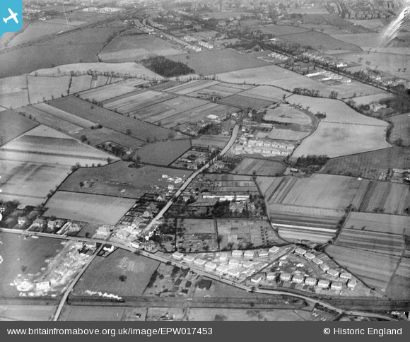
Train is going past Smith's Field, also a Rec Ground, now half built over |
JH |
Thursday 28th of June 2012 06:44:09 AM |
The footpath which crosses "Smith's field" to the bridge over the railway and on to the canal towpath began, before the houses were built, on the lane beside the house you were wondering about, which I thought might have been called "Oakdene". It ran roughly along the present fenceline of the back gardens of the houses in Crofton and Rossett Avenues and Garner and Burton Avenues. |
John Ellis |
Friday 13th of July 2012 01:18:32 AM |
Well spotted! Steam trains would cease to work the passenger services along the MSJ&AR just four years later when the railway was electrified and new electric trains introduced in 1931 at 1500Vdc. |
Paul |
Sunday 4th of December 2016 06:24:05 AM |
|
John Ellis |
Tuesday 26th of June 2012 10:02:25 PM | |
|
John Ellis |
Tuesday 26th of June 2012 10:00:55 PM |
Cyfraniadau Grŵp
When were you at Brookfield, Jean? I can't recall you from my time. Nor can I remember a girl with a learning disability, so maybe your time and mine didn't overlap. But your description of Mrs Beedle is spot on, as I recall her. When she gave up the school in 1957 she and Mr B. moved to Woodheys, the southernmost bit of Sale adjoining West Timperley. |
John Ellis |
Monday 13th of October 2014 04:31:03 PM |
At Brookfield House - in addition to Peter Horsfield; Dorothy and Timmy Jones, Terence Moss, Alan and John Astles, Tommy and Sylvia Budworth, Jimmy Woodward (and possibly Clive Reeves)? |
Kevin Ashton |
Saturday 13th of September 2014 06:54:41 AM |
Have just resisted sticking a peg on what in 1927 was still a field with the tag "Kevin Ashton's house was HERE!" And, recalling BHS, I'd add - quite at random - Rodney Bode and his sister, Olwen Holland, Carol Southern, Rita Hammond, Michael Watson, Michael Alexander, Abdul Salam (a pioneer of his kind), Colin Boothway (who messed about) and Elizabeth Wilson who could turn her face purple by holding her breath. Not to mention a kid called Edge whose first name I can't remember and whose dad made bottled pop and lived in Westwood Avenue, and one called Nelson whose dad had the hardware shop on Riddings Road. You can't still be working at Brooklands Station now it's all transformed into Metrolink, Kevin ... |
John Ellis |
Saturday 1st of February 2014 04:26:50 PM |
Brookfield House School. I went there from Kindergarten till I was nine years old. I loved that school. I wish I had as good a memory as some of you have as I can't remember any names of other children except one who was a friend called Rosemary Coles who lived in Brooklands. I think there was a boy called Richard who was getting into trouble a lot. I remembered the name 'Miss Lord' when I read it, so I must have known her. I really liked Mrs Beedle. I thought she was very kind, although I thought her husband was a bit frightening :-)). There was a little girl, who was accepted by Mrs Beedle as a pupil, I think somewhat reluctantly, who had a severe learning disability. Her mother wanted so much for her to learn to read and persuaded Mrs Beedle to admit her. I remember Mrs Beedle introducing her and her mum to the class. She was such a sweet and pretty little girl, but she was unable to learn even with one-on-one coaching, and she left after a few weeks. I think Mrs Beedle really wanted to help her... When my father died( January) and my mother realized she would be unable to pay the fees, and was going to transfer me to Frieston Rd. Mrs B. offered to let me stay on with no fees for the rest of the year, and even offered to let me stay on until I took the 11 plus. She said she knew I would pass. She even asked me if I would prefer to stay rather than going to the other school. I said I did not know, because I thought my mum might feel uncomfortable with that arrangement. But in my heart I really wanted to stay at BHS. I loved those huge rhododenrons in the front garden and sitting under them in the summer, and I remember when Mrs Beedle showed us where there were some scarlet pimpernels blooming between the crazy paving. I went back to see Mrs Beedle when I was 15 and she greeted me so warmly and took me in to meet a class. Afterwards she asked me all about how it had been in the other school and that she was glad I was at Altrincham Grammar. I told her that when I got to Frieston Road I was 2 years ahead of the children in the class in which I was placed, and that they couldn't even do 'running hand writing' and she beamed. I can still see her in my memory with her rather Edwardian hair do, grey-streaked and piled up on her head and her rather sharp nose, but she was a great teacher. Her favourite saying was, 'there is no such word as can't!' |
Jean |
Saturday 13th of September 2014 06:54:41 AM |
Hi John, for the past forty years I've lived just eight doors away from Dorothy Jones (as was), and we were trying to remember different ones from BHS. I remember a couple that you've mentioned - Rita Hammond; did she have red hair and live on the Grange estate? Carol Southern, Abdul Salam (who I remembered just recently to my wife as the first foreign person I had ever known!), and Nelson vaguely rings a bell. The others I don't recall, but was there also a Carol Lunt (Lunt's hairdressers near Timperly station), a Jennifer Newsome (or similar) and a Gabrielle Thompson? I also remember one other teacher - Miss Brown - although there were others. As for working - retired now, but apart from one short break in 1998, all on the railway - in total towards 150 stations in the end, from Holyhead all the way up to Workington! |
Kevin Ashton |
Monday 24th of February 2014 10:49:51 AM |
Hi Kevin I'm retired too, since end of 2006 - went to university in Wales and stayed there 20 years, but came back in '84 to be near my dad when he got ill and frail, and haven't managed to escape since! Currently in Hazel Grove. Yes, Rita Hammond did indeed have red hair - coppery rather than ginger - and always got the "Merit" badge; don't know where she lived, though. Jennifer Newsome's and Carol Lunt's names both ring a bell, but I can't recall faces. I couldn't remember Clive Reeves, though - and yet now it's in my head the surname "Reeves" does seem to strike a faint chord. I remember Gabrielle Thompson clearly, though - another one with coppery hair ... quiet voice, elfin face. Abdul Salam was the first foreigner I came across too - unless you count Gwilym Hughes for being Welsh. Remember him? He was severely mentally handicapped, but his mum wouldn't accept it and Mrs Beedle accepted him at BHS - we always thought it was because he provided her with another fee when her numbers were declining! I don't remember a Miss Brown among the teachers; other than the terrifying Mrs Beedle (we used to speculate what her initials E.G. stood for, and finally settled on "Ethel Gertie"!) I only remember Miss Spilsbury (young back then, taught me when I was first there) and Miss Lord - the senior teacher next to Mrs B., a big woman with curly grey hair who used to cycle to school from Hale each day on a bike with clicking gears. Dorothy and Timmy Jones I remember very clearly, though. I recall neither of them wanted to pass the 11+ exam because if they did they wouldn't be able to go to Welly Road with their friends! No one banged on about aspiration then, because jobs were there for the having. Intriguing to have run across you again. A few years back I found, via the net, a secondary school friend whom I'd not heard from since 1969. Even longer since I ran into you - I'd say late '50s, when I saw you on your way to Altrincham Grammar on the bus! |
John Ellis |
Wednesday 5th of February 2014 01:31:48 PM |
Hi John, Rita Hammond - I'm pretty certain she lived in 'The Triangle' on the Grange estate, just near Park Road. Clive Reeves had younger twin sisters, one named Victoria and the other also having a name beginning with 'V' - I can't remember now exactly what! The family lived on Bollin Drive (or possibly Downs Drive) and the father worked (I think) for a fruit & veg importer named Mayo. Possibly Clive didn't attend BHS, but as I "palled" with him for a while, I'm assuming he did. Gwilym Hughes I definitely remember, as our family knew the Hughes family quite well - believe it or not, I didn't start talking until I was nearly four, and my Mum and Mrs. Hughes had similar concerns. Sadly, Gwilym was actually diagnosed as severely autistic - as the doctors and local district nurses explained (in those earlier times), he was far from lacking in intelligence, but was unable to communicate with the 'normal' world. As our two families were somewhat more closely involved, all of us were able to gain some understanding of his behaviour. Of course, eventually (when his father died) he was an adult and too much for his Mum to cope with, and (if I recall) he was placed in a home that specialised in autistic cases, somewhere in Shropshire. Coincidentally, I started work on the railway at Sale station - Gwilym's father (Bill) was the chief clerk there, subsequently moving to Timperley station, where he retired. Now that you mention Miss Lord - I remember her; I suspect Miss Brown was not there for long, but I can't remember whether she was there before or after Miss Lord.... |
Kevin Ashton |
Friday 14th of February 2014 10:06:24 PM |
Kevin, I'm replying to you in the "chat" section of your profile rather than here, as it strikes me that however fascinating our reminiscences of the early 1950s on this patch of land are for us, they probably aren't interesting to anyone who didn't experience the gimlet-eyed gaze of Mrs Beedle as a pupil of Brookfield House School! |
John Ellis |
Monday 24th of February 2014 10:49:51 AM |
This has been invaluable in finding more out about the local area. Special thanks to John Ellis for all the insights! |
Wardy |
Sunday 10th of March 2013 09:11:58 PM |
As this is the area where I grew up, I had a head start! |
John Ellis |
Sunday 10th of March 2013 09:11:58 PM |
Dear all, As this image is currently the most commented-upon picture on the site, I thought I'd take a closer look prompted by all your contributions. Clearly we need to change the spelling of Hayes in our caption - so I've put that in hand and the change will appear here in due course (probably at the next data upload scheduled for late October/early November). On the 1877 25" Ordnance Survey map of the area the road name is "Heys Lane" and shows very clearly the different route that John Ellis describes. The lane bent round The Heys and Heys View. Heys View has a large area of glasshouses on the 1898 25" map. By the time of the publication of the 25" map in 1910 the old lane was still there but the newer, wider, straighter course - labelled as Heyes Lane - has been driven through. "The Heys" has gone by the third revision of 1935 and Heys View is then marked as "Fairlie Nurseries". I wonder if, given the range of detailed knowledge here, anyone would be interested in writing an entry in the Wiki tab for this image; which would help to bring all the information together in a history. yours, Katy Britain from Above Cataloguing Team Leader |
Katy Whitaker |
Wednesday 12th of September 2012 07:20:45 PM |
Hi Katy Well - the one photo on this site which shows the future location of the house where I grew up gets to be the most commented upon - fame (of a sort!) at last ... I've got a 1" to the mile OS map dated 1924, but my main information has come from the Chester Record Office's website, which carries the tithe maps from around 1840 and the OS maps of 1875 and 1910. It's a particularly useful site because it will set whichever old map that you choose on a pane next to a modern map, so it's possible to see exactly where modern roads and buildings stand in relation to the landscape as it was in the past. I'd happily have a go at writing this up on the Wiki tab, though I'd have to read up what's entailed - I've not read every detail of this site's info. yet. But there may well be other people who've got more specific and/or detailed knowledge than I have, who may do a better job. By the way, though the spelling in the 19th century seems to have been "Heys", it was "Heyes" by the 20th. John Ellis |
John Ellis |
Wednesday 12th of September 2012 07:20:45 PM |
This photo shows the area where I grew up, though nearly twenty years before I was born; and in 1927 when this photo was taken, the house I grew up in didn't exist, and wouldn't be built for another nine years. By the end of the 1930s, most of the fields in the area at the top of the picture had been built over by "modern semis". The house I grew up in was on a small estate built in 1936 in the field to the left of the wood (Beccles Wood, which is still there today) at the top of the picture. Heyes Lane - the correct spelling, not "Hayes" - runs up the middle of the picture, with what was Fairlie Nursery at the top - owned by the Horsfield family, and one of the final rural bits to be built over, in the early 1960s - along with "Wilford", another market garden just visible on the photo below and to the left of Beccles Wood. Park Road (B5165) runs left to right at the bottom of the picture, and Brooklands Road in Baguley across the top right corner - including a view of the local parish church of St John the Divine - built 1868. To the left of Brooklands Road is Framingham Road, of which only the northern section had been developed in the 1920s. At the far top left of the picture is the Manchester - Altrincham railway line (now part of the Manchester Metrolink system), which in 1927 was yet to be electrified. |
John Ellis |
Tuesday 26th of June 2012 09:51:41 PM |