
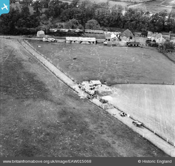
EAW015068 ENGLAND (1948). Chapel Pill Farm, Abbots Leigh, 1948. This image has been produced from a damaged negative.
© Hawlfraint cyfranwyr OpenStreetMap a thrwyddedwyd gan yr OpenStreetMap Foundation. 2026. Trwyddedir y gartograffeg fel CC BY-SA.
Manylion
| Pennawd | [EAW015068] Chapel Pill Farm, Abbots Leigh, 1948. This image has been produced from a damaged negative. |
| Cyfeirnod | EAW015068 |
| Dyddiad | 29-April-1948 |
| Dolen | |
| Enw lle | ABBOTS LEIGH |
| Plwyf | ABBOTS LEIGH |
| Ardal | |
| Gwlad | ENGLAND |
| Dwyreiniad / Gogleddiad | 353800, 175938 |
| Hydred / Lledred | -2.6653602655814, 51.48002404277 |
| Cyfeirnod Grid Cenedlaethol | ST538759 |
Pinnau

Matt Aldred edob.mattaldred.com |
Friday 8th of March 2024 11:56:17 AM | |

Class31 |
Thursday 19th of December 2013 08:50:11 PM | |
|
Class31 |
Thursday 19th of December 2013 08:49:21 PM |
Cyfraniadau Grŵp
I can't think what cereal crop would be left in a stack over winter and threshed in spring. Is the date of the photo definite? The lane is comprehensively blocked with bags of the end product. Notice that all of the corrugated iron buildings are camouflaged. |

clippedwings |
Wednesday 5th of February 2014 11:05:26 AM |
Hi Class31, thanks for the details. You may be interested to know that the original Aerofilms Ltd Register entry reads "Hay making Nr. Bristol" - a bit odd! We'll update the catalogue and post the new data here in due course. Yours, Katy Britain from Above Cataloguing Team Leader |
Katy Whitaker |
Tuesday 7th of January 2014 02:58:51 PM |
If this were a September photo I would have thought that the intense activity would be threshing corn after harvest but this is an April photo. Does anyone know what activity is taking place? |
Class31 |
Thursday 19th of December 2013 09:03:16 PM |
EAW015069 is the adjoining photo taken on the same day. I thought I could see a river through the trees in this photo. I didn't have far to look. It's interesting that there is a Chapel Pill in both photos. They are different ones but with the same name only a few miles apart. |
Class31 |
Thursday 19th of December 2013 08:57:59 PM |
View is looking north west. |
Class31 |
Thursday 19th of December 2013 08:51:21 PM |
Chapel Pill Farm |
Class31 |
Thursday 19th of December 2013 08:47:57 PM |