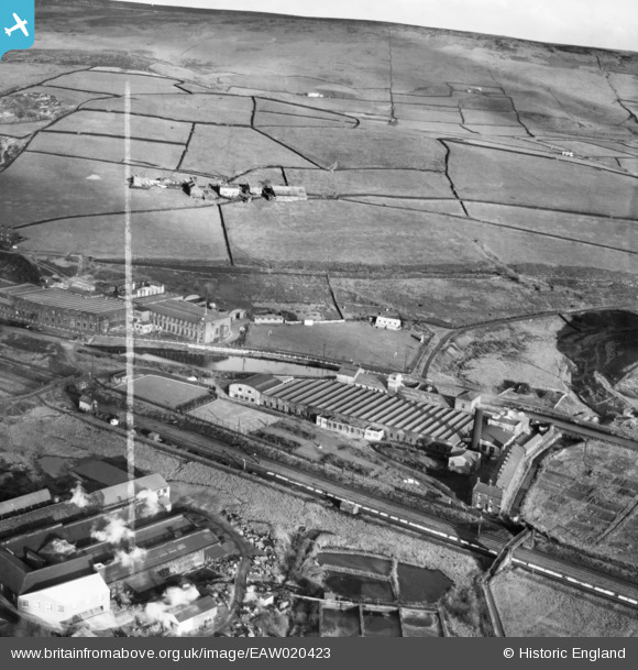
EAW020423 ENGLAND (1948). Green Vale Cotton Mill and environs, Calderbrook, 1948. This image was marked by Aerofilms Ltd for photo editing.
© Copyright OpenStreetMap contributors and licensed by the OpenStreetMap Foundation. 2024. Cartography is licensed as CC BY-SA.
Nearby Images (14)
Details
| Title | [EAW020423] Green Vale Cotton Mill and environs, Calderbrook, 1948. This image was marked by Aerofilms Ltd for photo editing. |
| Reference | EAW020423 |
| Date | 8-November-1948 |
| Link | |
| Place name | CALDERBROOK |
| Parish | |
| District | |
| Country | ENGLAND |
| Easting / Northing | 394759, 417745 |
| Longitude / Latitude | -2.079309975216, 53.655941668217 |
| National Grid Reference | SD948177 |
Pins
Be the first to add a comment to this image!


![[EAW020423] Green Vale Cotton Mill and environs, Calderbrook, 1948. This image was marked by Aerofilms Ltd for photo editing.](http://britainfromabove.org.uk/sites/all/libraries/aerofilms-images/public/100x100/EAW/020/EAW020423.jpg)
![[EAW020426] Sladen Fold above cotton mills in the Roch Valley, Calderbrook, 1948. This image was marked by Aerofilms Ltd for photo editing.](http://britainfromabove.org.uk/sites/all/libraries/aerofilms-images/public/100x100/EAW/020/EAW020426.jpg)
![[EAW020434] Rock Nook Cotton Mill and environs, Calderbrook, from the south, 1948. This image was marked by Aerofilms Ltd for photo editing.](http://britainfromabove.org.uk/sites/all/libraries/aerofilms-images/public/100x100/EAW/020/EAW020434.jpg)
![[EAW020428] Green Vale Cotton Mill, Calderbrook, 1948](http://britainfromabove.org.uk/sites/all/libraries/aerofilms-images/public/100x100/EAW/020/EAW020428.jpg)
![[EAW020431] Rock Nook Cotton Mill, Calderbrook, from the south-west, 1948](http://britainfromabove.org.uk/sites/all/libraries/aerofilms-images/public/100x100/EAW/020/EAW020431.jpg)
![[EAW020435] Rock Nook Cotton Mill and environs, Calderbrook, from the south-west, 1948](http://britainfromabove.org.uk/sites/all/libraries/aerofilms-images/public/100x100/EAW/020/EAW020435.jpg)
![[EAW020420] Grove Dyeing and Finishing Works and environs, Calderbrook, 1948. This image was marked by Aerofilms Ltd for photo editing.](http://britainfromabove.org.uk/sites/all/libraries/aerofilms-images/public/100x100/EAW/020/EAW020420.jpg)
![[EAW020427] A passenger train drawn by LMS Class 5 ("Black Five") 4-6-0 5226 passing the Green Vale Cotton Mill, Calderbrook, 1948](http://britainfromabove.org.uk/sites/all/libraries/aerofilms-images/public/100x100/EAW/020/EAW020427.jpg)
![[EAW020430] Rock Nook Cotton Mill and environs, Calderbrook, 1948. This image was marked by Aerofilms Ltd for photo editing.](http://britainfromabove.org.uk/sites/all/libraries/aerofilms-images/public/100x100/EAW/020/EAW020430.jpg)
![[EAW020424] Green Vale Cotton Mill and the Roch Valley, Calderbrook, from the south, 1948. This image was marked by Aerofilms Ltd for photo editing.](http://britainfromabove.org.uk/sites/all/libraries/aerofilms-images/public/100x100/EAW/020/EAW020424.jpg)
![[EAW020419] Grove Dyeing and Finishing Works and cotton mills along the Rochdale Canal, Calderbrook, 1948. This image was marked by Aerofilms Ltd for photo editing.](http://britainfromabove.org.uk/sites/all/libraries/aerofilms-images/public/100x100/EAW/020/EAW020419.jpg)
![[EAW020433] Rock Nook Cotton Mill and environs, Calderbrook, from the south-west, 1948. This image was marked by Aerofilms Ltd for photo editing.](http://britainfromabove.org.uk/sites/all/libraries/aerofilms-images/public/100x100/EAW/020/EAW020433.jpg)
![[EAW020429] Rock Nook Cotton Mill and environs, Calderbrook, from the west, 1948. This image was marked by Aerofilms Ltd for photo editing.](http://britainfromabove.org.uk/sites/all/libraries/aerofilms-images/public/100x100/EAW/020/EAW020429.jpg)
![[EAW020421] Grove Dyeing and Finishing Works and environs, Calderbrook, 1948. This image was marked by Aerofilms Ltd for photo editing.](http://britainfromabove.org.uk/sites/all/libraries/aerofilms-images/public/100x100/EAW/020/EAW020421.jpg)