
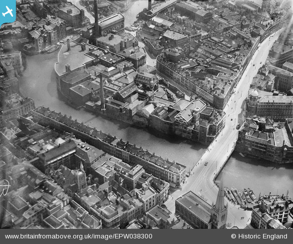
EPW038300 ENGLAND (1932). George's Brewery and Bristol Bridge, Bristol, 1932
© Hawlfraint cyfranwyr OpenStreetMap a thrwyddedwyd gan yr OpenStreetMap Foundation. 2024. Trwyddedir y gartograffeg fel CC BY-SA.
Delweddau cyfagos (27)
EPW038300

EPW038303

EPW038304

EPW033498

EPW038302

EPW038301

EPW034455

EAW032259

EPW034460
 and the Tramway Generating Station, Bristol, 1930")
EAW032257

EPW034452

EAW032254

EAW032256

EAW032258

EPW034451

EPW034458

EPW034459
 and the Tramway Generating Station, Bristol, 1930")
EPW034454
 and the Tramway Generating Station, Bristol, 1930")
EPW034453

EPW060117

EPW034457

EAW032261

EPW034450

EAW032260

EAW032255

EPR000072

EPW034456

Manylion
| Pennawd | [EPW038300] George's Brewery and Bristol Bridge, Bristol, 1932 |
| Cyfeirnod | EPW038300 |
| Dyddiad | June-1932 |
| Dolen | |
| Enw lle | BRISTOL |
| Plwyf | |
| Ardal | |
| Gwlad | ENGLAND |
| Dwyreiniad / Gogleddiad | 359078, 172934 |
| Hydred / Lledred | -2.5890046029914, 51.453418421511 |
| Cyfeirnod Grid Cenedlaethol | ST591729 |
Pinnau
 adfbristol |
Thursday 16th of April 2020 01:48:15 PM | |
adfbristol |
Thursday 16th of April 2020 01:47:03 PM | |
MB |
Sunday 20th of January 2013 11:07:40 PM | |
MB |
Sunday 20th of January 2013 11:06:21 PM | |
 Class31 |
Sunday 20th of January 2013 11:05:52 PM | |
Class31 |
Sunday 20th of January 2013 11:05:10 PM | |
Details of Bridge Street in 1937 here: www.flickr.com/photos/brizzlebornandbred/2056421543/in/photostream/ |
MB |
Sunday 20th of January 2013 11:21:37 PM |
Class31 |
Sunday 20th of January 2013 11:04:36 PM | |
Class31 |
Sunday 20th of January 2013 10:54:42 PM | |
Class31 |
Sunday 20th of January 2013 10:54:11 PM | |
MB |
Sunday 20th of January 2013 06:01:45 PM | |
MB |
Sunday 20th of January 2013 06:00:00 PM | |
MB |
Sunday 20th of January 2013 05:59:43 PM | |
MB |
Sunday 20th of January 2013 05:59:14 PM | |
I'm afraid not. The is St. Mary le Port Church. St. Peter's is further east of this location. |
Class31 |
Sunday 20th of January 2013 11:02:39 PM |
MB |
Sunday 20th of January 2013 05:58:54 PM | |
MB |
Sunday 20th of January 2013 05:58:25 PM | |
MB |
Sunday 20th of January 2013 05:58:07 PM |
Cyfraniadau Grŵp
More on Mary-le-Port Street: www.flickr.com/photos/brizzlebornandbred/2056421861/ The tower of St Mary-le-Port survived the German bombing; I've incorrectly labelled the church St Peter's, which as Class 31 points out is further to the east |
MB |
Sunday 20th of January 2013 11:17:13 PM |
The tramlines are clearly visible on Bristol Bridge; the sunlight reflecting off them |
MB |
Sunday 20th of January 2013 11:02:43 PM |


