
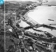
EAW020170 ENGLAND (1948). The Western Docks and environs, Dover, 1948. This image has been produced from a print marked by Aerofilms Ltd for photo editing.

© Copyright OpenStreetMap contributors and licensed by the OpenStreetMap Foundation. 2026. Cartography is licensed as CC BY-SA.
Nearby Images (18)
EAW020170

EAW020173

EAW020183

EAW020171

EAW020179

EAW020172

EAW020169

EAW020174

EAW020184

EAW020180

EAW020181

EAW020182

EPW000357

EPW019054

EAW007615

EAW020175

EAW020177

EAW020178

Details
| Title | [EAW020170] The Western Docks and environs, Dover, 1948. This image has been produced from a print marked by Aerofilms Ltd for photo editing. |
| Reference | EAW020170 |
| Date | 28-October-1948 |
| Link | |
| Place name | DOVER |
| Parish | DOVER |
| District | |
| Country | ENGLAND |
| Easting / Northing | 631799, 140817 |
| Longitude / Latitude | 1.3126077353015, 51.119142267306 |
| National Grid Reference | TR318408 |
Pins

brianbeckett |
Thursday 26th of March 2020 09:02:52 PM | |
|
mannidaze |
Friday 25th of January 2019 03:24:08 PM | |
|
cptpies |
Tuesday 31st of March 2015 10:34:21 AM | |
|
cptpies |
Tuesday 31st of March 2015 10:33:43 AM |
User Comment Contributions
Dover Quad and Artillery Battery, Western Docks, Dover. |
cptpies |
Tuesday 31st of March 2015 10:36:12 AM |